As we approach the coldest months of the year, all I can think about is sunny Guatemala, where I spent the month of July this past summer. I direct the La Florida Archaeology Project, together with my colleague Liliana Padilla. La Florida is an ancient Maya site, once known as the center of the Namaan polity. Today the site is located in the middle of the town of El Naranjo, a growing community on the southern bank of the beautiful San Pedro River. There is no better place to spend a month of archaeological survey, intermixed with ice cream cones and trips to the swimming hole.

Maya Kingdoms
During the Classic Period, the Maya world was divided among a number of semi-autonomous kingdoms, each centered at a royal court, and each a member of larger networks of allies and rivals that stretched across the southern Maya lowlands.
The Penn Museum has long played a role in exploration and research in the Maya area. For example, in the 1930s, the Museum sent an expedition to the site of Piedras Negras, with the collaboration of the Guatemalan government, to excavate and recover carved monuments. Today, most of the artifacts recovered during this expedition are in Guatemala, but you can see Stela 14 and a set of carved shells in the Mexico and Central America Gallery of the Penn Museum. These shells reveal an interesting story: recovered by Penn Museum researchers from a royal tomb, they tell of the marriage of Piedras Negras ruler K’inich Yo’nal Ahk to a 12-year-old princess from the Namaan kingdom. This marriage was apparently arranged by K’inich Yo’nal Ahk’s father, the aging previous king. Though he died just before the wedding, this final act secured both a political alliance with Namaan as well as his son’s strong claims to the throne.
For many years, the location of the Namaan polity remained a mystery, though it was mentioned in the inscriptions of several other sites such as Yaxchilan and El Peru. Today, we can also identify mentions of this polity in ceramics from La Corona, Motul de San Jose, and Zaculeu. This distribution suggested a polity with widespread political contacts—both friendly and hostile. In 1998, the epigrapher Stanley Guenter identified the Namaan glyph on Stela 7 of La Florida. A second Namaan glyph was identified by Guido Krempel on Stela 2 in 2011. Today, it is widely accepted that La Florida was the seat of the Namaan polity and a strong ally of Piedras Negras.
La Florida’s position on the San Pedro River was strategic. From its origins in Guatemala, this river flows westward to the Tabasco Plain of Mexico, a fertile region known in Precolumbian times for its chocolate production. La Florida controlled the flow of Tabasco’s agricultural wealth to the dense urban zones of the Maya heartland.


Research at La Florida
Edwin Shook was the first archaeologist to visit La Florida in 1943. He made a sketch map and recorded several carved monuments. Since that time, the site has been visited by other archaeologists and epigraphers, though none of its structures have been excavated. Maps were drawn by both Ian Graham in 1965 and Paulino Morales in 1997, but neither researcher had the benefit of a total station or GPS for precise measurements.

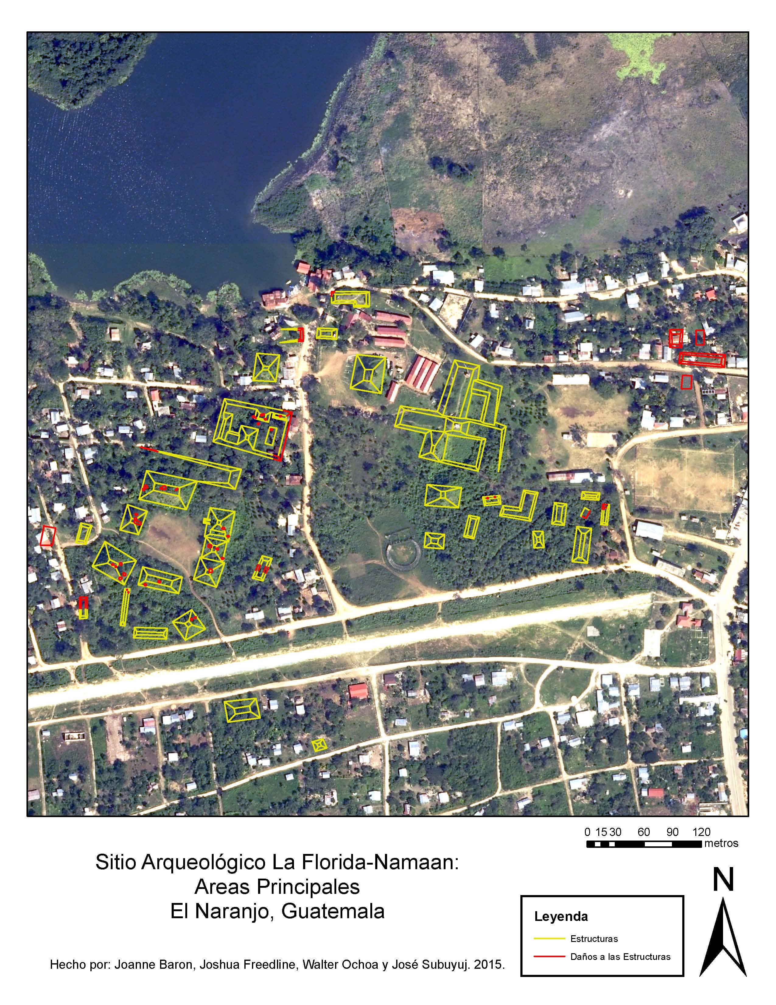
With funding from the Penn Museum, the main goal of the La Florida Archaeology Project in July was to update these maps using more precise measurements. Joining us on the project this year were José Subuyuj and Walter Ochoa, two students at San Carlos University in Guatemala City and Joshua Freedline, a masters student at Brandeis University in Boston. We also worked with Rene Aguilar, a native of El Naranjo. Together, the four of us mapped the main structures of the site. In the process of mapping, we also documented many looters’ pits, the majority of which are small holes that thankfully only damaged the structures minimally. The map and observations that we made this year lay the groundwork for future seasons of excavation.
La Florida was built for maximum visibility and control of the San Pedro River. Many of the structures we mapped have commanding views of the river. River access is provided via an inlet that even today is used by boaters as shelter from strong winds. Here, an ancient Maya canoe pilot would have encountered a terraced slope with platforms that funneled foot traffic to an area dominated by the site’s royal palace. In 2014, we discovered other mounds across the river as well, positioned for maximum visibility around a set of river bends. This year, we were allowed access to the finca “El Niño,” where we saw four more large structures with views of the river.

El Naranjo Today
While most sites in Guatemala’s Peten region are remote, La Florida is located in the middle of a large town. El Naranjo is officially an aldea or “village” within the municipality of La Libertad, whose municipal seat is located about two hours away. Just like the ancient site, El Naranjo sits on a major commercial corridor—the town ferry is the only river crossing to provide vehicle access to petroleum wells north of the river, and personnel and equipment regularly pass through. It is also located just 20 minutes from the Mexican border and the El Ceibo customs station and sees a constant flow of commercial products. And like the ancient site, El Naranjo has turned this strategic position to its advantage with increased economic prosperity, population, and political autonomy. Today, El Naranjo and surrounding areas are home to around 23,000 people. It has modern amenities such as a health center, bank, hotels, restaurants, and hardware stores. This year it received permanent electrical lines for the first time. And El Naranjo is in the process of becoming its own municipal seat. By splitting from La Libertad—currently one of the largest municipalities in the entire country—El Naranjo would gain access to additional funding for public projects and infrastructure.

Living in El Naranjo is certainly convenient for the archaeologist—we had easy access to supplies and good food. We got to rent a house right next to the ruins and meet all our neighbors. And town residents were quick to help us with information and show us artifacts they had found in their yards. But as the town grows and expands, urban development inevitably means damage to ancient structures. Upon our visit in 2014, town officials asked us to provide them with a map of the ruins to assist them in protecting the site from further urban development. On the completion of our work this year, we gave maps to town leaders to assist them in this task.
Conducting an archaeological project at La Florida requires the collaboration of the people of El Naranjo. They live among the site’s ancient structures and stand to benefit economically from its development, both in direct employment on the project and in the nascent ecotourism industry. As we move forward with an excavation project, it will be necessary to work closely with the town to make sure that looting does not increase. We had many conversations with residents emphasizing the importance of preserving the site (most of the residents we talked to strongly shared this desire for preservation). We held a workshop with around 150 students from local schools to talk about what an archaeologist does and why it is important to protect the site. And we created pamphlets about La Florida to distribute. These were originally created for town officials to give out to visitors, but we found that residents themselves were excited to read about the site’s archaeological importance.

Plans for 2016
We plan to return to La Florida in 2016 to begin excavations with the collaboration of the El Naranjo community. We hope you too will visit El Naranjo to see the ruins, take a boat up the San Pedro River, or hike in the nearby hills. Help us spread the world about this little-known part of Guatemala!