
-

- A survey team stands at the edge of a deep wadi, or canyon. This part of the desert is heavily dissected by such wadis, and it is quite likely that early humans took advantage of such views to locate prey.
-

- Team members, using small handheld computers with attached calipers, take measurements and other observations on the artifacts found in the circle.
-

- A team member draws a circle of 1-meter radius on the surface and begins to collect the artifacts within.
Most Expedition readers will be familiar with the Museum’s longstanding Egyptian research project at Abydos, which focuses on Abydos’s ancient yet historically known past, and was most recently presented in a special issue of Expedition in 2006 (vol. 48-2). In contrast, the following research focuses on Abydos’s far more distant and prehistoric past.
The origin of modern humans and their ultimate spread throughout the world is one of the most important research topics in human evolution. Evidence from many diverse sources, including genetics, human paleontology, and archaeology, now points to an African origin for modern humans—in both their anatomy and behavior—sometime around 195,000 to 160,000 years ago. By about 100,000 years ago modern humans had made it as far at the Levant (modern day Israel, Palestine, Lebanon, and Syria), but it was not until about 50,000 to 40,000 years ago that our ancestors rapidly colonized most of the rest of the world, replacing other existing human species, including the Neandertals, along the way.
Most researchers assume that the Nile Valley in northeast Africa was the route used by these early moderns to move out of Africa into Asia, Europe, and beyond. Today, this landscape is very arid with few signs of life. Because water is the single most important resource for humans, one might logically expect to find evidence of these early moderns near major water resources—a perception that probably has prevented most archaeologists from venturing too far afield from today’s oases and the Nile itself in their search for traces of human activity. However, from about 128,000 to 100,000 years ago, during the Middle Paleolithic period, this region’s climate was more humid than today and would have provided a more appealing environment for humans, allowing them to operate further from today’s water resources, possibly even on the high desert plateaus.
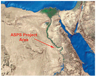
To test this hypothesis and to learn more about our early modern ancestors and their adaptations at this critical time in human prehistory, the Penn Museum began archaeological fieldwork in the Egyptian high desert to the west of the historic ancient town of Abydos. This project, named the Abydos Survey for Paleolithic Sites (ASPS), began in the year 2000 and had its most recent field season in December and January of 2007–2008. The abundant evidence of stone tools that we found there clearly supports the interpretation of early modern human occupation in this area.
Our Research Methodology
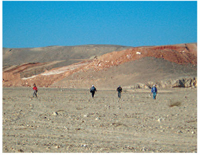
Our research project does not focus on archaeological ‘sites’ in the traditional sense of the term used by archaeologists. Rather, we are interested in the overall distribution of archaeological finds across the desert landscape. To obtain this information, we undertake a survey, which basically means walking across an area and looking for artifacts using small teams of three to four archaeologists working together. Each team walks along a line, with a couple of meters of space between each person. As they walk, each person looks at the ground and lets others know if they observe any artifacts. If several people start finding artifacts at the same time, it usually means that they have found or are near a relatively high-density locale—what we call a ‘site.’ When we find a site, we draw a one-meter radius circle in the densest part of the site and then pick up and examine all the artifacts in the circle, thereby getting a sense of the nature of the site.
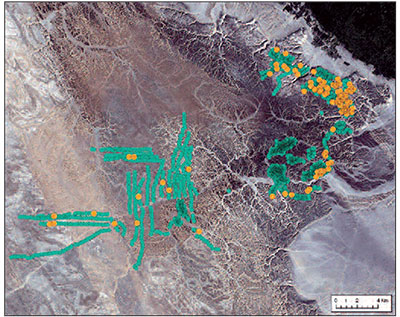
But while it is important to document these higher-density sites, it is also important to quantify the overall background distribution of artifacts across the landscape because not all artifacts are found in the context of a site. So, every 100 meters each team stops and draws a similar circle and collects whatever artifacts they find there. Although many of these circles have no artifacts at all, roughly half contain at least one, and, as a result of this methodology, we can quantify more precisely where artifacts do occur and where they do not and then calculate the relative density of artifacts across the entire landscape. To date we have collected 1,916 of these 100-meter samples and have found 185 high-density sites.
Each team carries with it all of the equipment necessary to record the details of what it finds. A handheld GPS recorder determines the exact location of each circle—whether a site or 100-meter sample—and a digital camera photographs the contents of the circle. The team then excavates the circle and screens its contents in order to recover any small artifacts. Using handheld computers equipped with digital calipers, team members then study and measure each stone artifact on location, bringing only particularly interesting ones back to camp for further study. In this way, most of the finds remain in the field (which helps to preserve the archaeological record there), though the data required for analysis is still recovered.
Base Camp
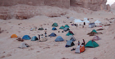
Each season our team sets up a different base camp. In a region that is relatively remote and has few roads available for transport, it is important to locate this camp as close as possible to each particular season’s study area. These camps tend to be fairly large since the average archaeological crew often numbers between 15 and 20 individuals, plus a number of camp staff who manage the camp and prepare meals. Furthermore, Egyptian antiquities regulations require that we have a number of armed security guards, one of whom must accompany each team during the daily surveys. While many of our student participants often complained about the presence of these guards, they proved valuable when one of our survey teams stumbled across a group of armed looters!
A Paleolithic Pompeii
Our study area is not dissimilar from what one sees in photos of the barren, rocky landscape of Mars. In fact, this special kind of surface is known as a desert pavement—essentially a thin layer of more or less interlocking, thermally fractured flints (originally released from the surrounding Eocene limestone by aeolian erosion as well as by chemical weathering during times of humid climate), limestone fragments, and gravels. Desert pavements are relatively stable surfaces with slight or no lateral movement of materials and minor or no buildup of sediments above the pavement surfaces. As a result, artifacts, once dropped on this surface, move very little before they eventually become part of the desert pavement. Once that occurs, they become essentially “locked” in time.
One of the implications of this process is that there are no buried archaeological deposits on any of the open surfaces in this environment. Thus, virtually every artifact that was dropped to the ground here in the past is still visible to archaeologists today as we walk across the landscape. Furthermore, the lack of disturbance means that the objects themselves are more or less intact (although most of them do exhibit some damage due to the occasional trampling by humans or other animals and/or from wind erosion).
A real benefit of this preservation situation is that all of the by-products that result from making stone tools can be recovered by archaeologists. In other words, when a tool-maker makes a stone tool in this environment, all of the small “flakes” that are knocked off the original flint nodule, or core, are normally left right on the surface of the ground (unless the tool-maker decides to keep one or more pieces for further working into tools). As a result, a scatter of waste material, or debitage, will typically accumulate at the location where a tool-maker undertook his or her flintknapping. From an archaeological point of view, this scenario presents an almost unique opportunity for scholars to collect all of this waste material and try to refit the pieces together. Refitting, or putting these flakes back together as in a three-dimensional jigsaw puzzle, gives archaeologists important insights not only into how stone tools were made but also where they were made and used.
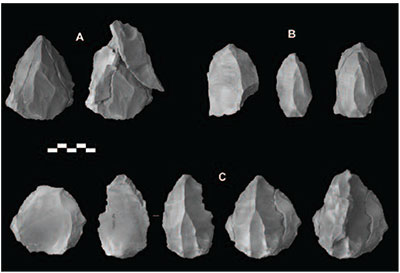
For example, at Site ASPS4011—a concentration of stone artifacts covering about 120 m2 that was located in the western part of the 2005–2006 study area on a large plateau between a small rise of exposed limestone and the edge of a cliff we discovered three Middle Paleolithic cores that could be partially refitted.
Based upon these refits, we can say a number of things. One, the raw material used to make these artifacts was imported from elsewhere since our survey noted no naturally occurring flint of the same kind in the immediate vicinity. Two, only some of the initial preparation of these cores took place at the site. This was indicated by the discovery of only a few pieces of the initial removal flakes from one of the cores. For the other two cores, only the last round of removal flakes were found. As a result, it is clear that site A4011 formed only one part of the early modern human use of the larger landscape—other locations were used to collect raw material and prepare (at least initially) their tools.
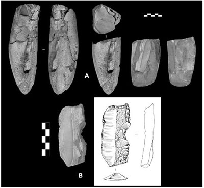
This, however, was not always the case. For example, we obtained an almost complete refit at one of our non-site 100 meter sample locations, S3137. This 1-meter radius circle included about 20 stone artifacts, tightly grouped together, which all came from the same original flint nodule (again, of a type not otherwise found in the vicinity).
Refitting these 20 pieces together produced a largely cylindrical nodule (233 mm in length) that had been clearly knapped to produce long thin flakes. By reversing the refitting process and peeling the pieces off in order one by one, we were able to reconstruct the tool-maker’s original flintknapping sequence.
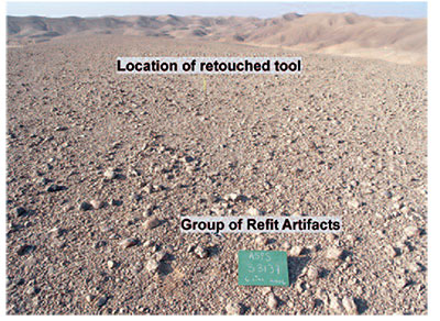
It started with the removal of one end of the block (interestingly, the only piece that was not recovered here—see below). This, in turn, created a large platform at one end of the nodule for the tool-maker to remove long slender flakes down the nodule’s long sides by striking this platform. This process apparently proceeded until the tool-maker either exhausted the nodule core (which was left here with the other waste flakes) or removed a flake that was deemed acceptable for tool use. This latter artifact—a retouched blade—was fortuitously found about 5 meters away from the original sample location. Of all the flakes removed from the nodule core, only this one showed any sign of further modification from its original shape, indicating that it may have been used for some purpose.
During our survey of this area we found no other flint nodules of the same type. As with the refits from Site ASPS4011, this indicates that this nodule was picked up elsewhere, tested as a suitable source of flint (by removing the first flake to produce a platform), and then carried to this spot (S3137) where the rest of the tool-making sequence took place. The almost complete refit, along with the close proximity of all of the pieces (including the tool), clearly shows that all of this toolmaking and tool-using activity took place here.
This kind of archaeological resolution and visibility is amazing. To find knapping stations, particularly for sites of this age, is very rare. It is all thanks to the stability of the land surface in the Egyptian high desert. Here, artifacts stay where they are dropped, they are not covered by the accumulation of later materials, and there is virtually no vegetation to hide them from view. This makes it very easy for archaeologists to recover everything and to do so quickly and efficiently. This is not at all like normal excavations, where the cost of digging usually limits the amount of area that can be exposed.
What we have already found is that early modern humans occupied this desert area right at the time when the migration out of Africa first occurred. While we are still far from understanding their adaptation to this particular environment, the archaeological resolution we are discovering is giving us an exceptional view of what they were doing over a large area. We are hopeful that further research will eventually allow us to reconstruct more of the details of what they were doing here and, perhaps, understand the reasons why they left the African continent.