The second in a series of articles about the finding and naming of some of the islands in the Pacific- the Maori great Sea of Kiwa.
No source I could find seemed willing to say just exactly how many islands there are in the South Pacific. There are thousands of them, to be sure, approximately ten thousand and every one of them by now has been named one or more times. Counting the islands does pose a number of problems. A check of even the most up-to-date British Admiralty, U.S. Hydrographic, and U.S. Air Force maps reveals a surprising number of islands (not to mention reefs and shoals) marked “existence doubtful.” Even more are marked “position doubtful” or “reported 15 minutes east of position shown,” for example; some are shown with an indefinite line, meaning they have never been accurately surveyed. In the past it has sometimes happened that a thorough survey has shown the existence of several islands where it was thought there was only one. The reverse has occurred, also: Australia had had permanent settlers for almost twenty years and Port Jackson, or Sydney, was a flourishing town, before Matthew Flinders conclusively established that Australia was all of one piece. Similarly, the Pacific gazeteers lost three islands when it was found that Raoul, Willaumez, and Gicquel werenn’t islands at all but together formed the Willaumez Penninsula on the northern side of New Britain– or New Pommern as it was called when it was a German colonial possession.
Another of the problems in counting and naming islands is what do you count of name? Truk is a case in point. It is commonly referred to simply as Truk, as if it were a single island. Actually, there is no single island named Truk. Rather, Truk is a group of islands–nearly ninety of them– situated either on or within a great encircling reef. While some are coral islets, the islands within the reef are of volcanic origin, several of them more than a thousand feet high. Truk (which has also been called Ruk, Chuuk, Torakku, and Hogoleu) was one of the largest Japanese bases during World War II, and now, like the rest of the Caroline Islands, is part of the U.S. Trust Territory of the Pacific Islands. Incidentally, this Trust Territory, which includes the Micronesian island groups of the Carolines, Marshalls, and Marianas, is supposed to have 2,141 individual islands in it alone!
An accurate count of the South Pacific islands is also difficult because every so often new islands appear and old ones disappear. The floor of the Pacific Ocean is by no means stable, and there is considerable volcanic activity in many parts of it. A submerged reef may be raised high enough above the ocean level so that it is not constantly washed by the tides. Time passes, the elements break down the coral rock into sand; more time passes and the sand become capable of supporting plant life, and eventually there exists a small spot of land complete with a palm tree! New islands are in the slow process of being created this way all the time, although the process is very much more complicated than I have suggested.
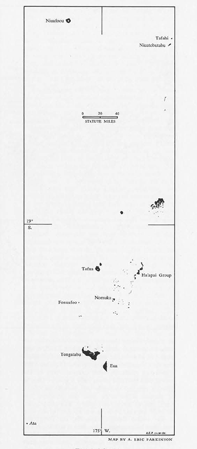
Some islands are created in a much more dramatic way: volcanic cones raise themselves out of the ocean depths. Even today this is not an unusual occurrence. The submerged volcanic chain around the Bismarck Sea has been particularly active in recent years. Several islands have been named Volcano in honor of their origin, such as the one in Blanche Bay, New Britain, which arose from the sea in February, 1878. These new islands don’t always stay up, and some of them appear and disappear like a jack-in-the-box. One of the best known of these is Falcon Island or Fonuafoo, west of the Ha’api group in the Tonga Islands. Reefs were first recorded in this area by the Spanish explorer Maurelle in 1781. In 1865 H.M.S Falcon (from which the island gets its name?) saw it as a reef, but in the same year the Sappho saw smoke coming from it. In October, 1885, it was observed as an island composed of volcanic ashes one and a quarter miles long and 153 feet high. The ashes gradually were carried away by the waves, and by 1894 it was only a shoal. Then in 1896 it erupted violently and became an island of pumice stone more than one hundred feet high. About three years later it was gone again.
In 1927 another re-birth was so spectacular that it was visible from Nukualofa, on Tongatabu forty-five miles away. This time a pumice island one and one-half miles long and 360 feet high was formed. Again it eroded and was quiet until 1955 when it erupted for at least the fourth time in recorded history. The Pacific Islands Year Book, from which this account is taken, also notes that the Tonga Government annexes it anew every time it appears!

Several of the “high” or volcanic islands are, or contain, active volcanoes. One of these is Niuafoou in the extreme northern end of the Tonga Islands. Niuafoou may have been discovered by the early Dutch explorers Le Maire and Schouten and named “Good Hope.” This was on May 14, 1616, but in July, 1791, Captain Edward Edwards, who had been sent out by the Admiralty in the Pandora to search for the Bounty’s mutineers, was ignorant of the possible Dutch discovery and claimed it as a new find which he called “Probys Island.” It may also, at one time or another, have been called “Hope” and “Captain Charles Hope.” However, the most interesting thing about it is its nickname– “Tin Can Island”– from its unique method of getting mail. Out-going mail was made up ashore into several packages which were tied to the ends of three-foot long sticks. Two or three natives, lying on top of a rude raft made of poles and carrying the mail sticks above their heads, swam out to the waiting steamer. When they came alongside, buckets were lowered from the ship and the natives put the mail packages in them. In-coming mail was sealed in forty-pound biscuit of kerosene tins on the ship and lowered to the swimmers who returned to shore with it. This unusual system of mail delivery grew to considerable proportions when its story reached philatelists. It was discontinued during World War II but had just been resumed when a very serious eruption devastated a large part of the island, and the inhabitants were removed. Since Niuafoou had a long history of bad eruptions, the Tonga Government decided to re-settle the inhabitants on another island– Eua, also called “Middleburgh.” Only a few men working as copra-makers live on the island now, so the “Tin Can Mail” seems to be gone forever.
Disappearing islands, like Falcon, may account for a few of the islands once reported but never found again. Most of these “lost” islands, however, didn’t really disappear; they just can’t be identified with existing islands because the original discoverers did not report their positions accurately enough. This is the case with some of the islands discovered by the earliest Pacific explorers, the Spanish and the Dutch. It was scarcely the fault of the navigators: latitude could be fixed with some degree of accuracy, but establishing longitude was almost a matter of guess work. At one point in his journal the early Dutch explorer, Abel Tasman, admitted his reckoning might be eight hundred miles off!
One of the ways of finding longitude was to calculate the ship’s speed and plot it against the compass course. The most common method was to plot position by astronomical observations. Such methods depended on fair weather and disregarded the effects of wind and current; after a ship had been wandering around the Pacific for months, position calculated by the ship’s progress became almost meaningless. Although the spring-driven clock had been invented in 1500, it was not until the 1700s that it was recognized that this invention had become accurate enough to compute longitude at sea. I refer, of course, to the chronometer, one of the most important inventions in the history of navigation. The problems of establishing longitude had become so complex that England had set up a special “Board of Longitude,” and the need for an accurate measuring device had become so imperative that the Board spent over one hundred thousand pounds between 1714 and 1728 in perfecting the chronometer (says Kroeber in Anthropology, and he further notes that this is one of the first times in our economic history that an invention had been purposely financed). By 1735 the chronometer was in use, but it still had many “bugs” and the journals of most of the later eighteenth century navigators, such as Cook, contain discussions on its accuracy and use.

One of the first Pacific navigators to really rely on chronometers was a Frenchman, John Francis Galaup de la Perouse. The object of La Perouse’s voyage was to check on previous discoveries in the Pacific and he sailed from Brest on August 1, 1785, with two frigates, the Boussole and Astrolabe. He sailed east and west and north and south across the Pacific for three years, but his fame rests not on the discoveries he verified, nor the new islands he found, nor even on his use of chronometers, but on the fact that he never returned to France. His journals were sent back from Australia, where he was last seen. His fate was a tragic one, and the mystery of it gave rise to several expeditions– among them D’Entrecasteaux’s– discovered far more, and more important, islands than had La Perouse. For almost forty years every navigator in the Pacific watched for evidence of La Perouse, but the mystery was not solved until 1826 when one Peter Dillon noticed items of French manufacture in possession of natives on Tikopia. The Tikopians reported that they came from Vanikoro (or Mannicolo, or Malicolo), an island in the Santa Cruz group. The following year Dillon commanded a ship sent out by the Bengal Government to Vanikoro, and there he found the remains of La Perouse’s two vessels on a reef.
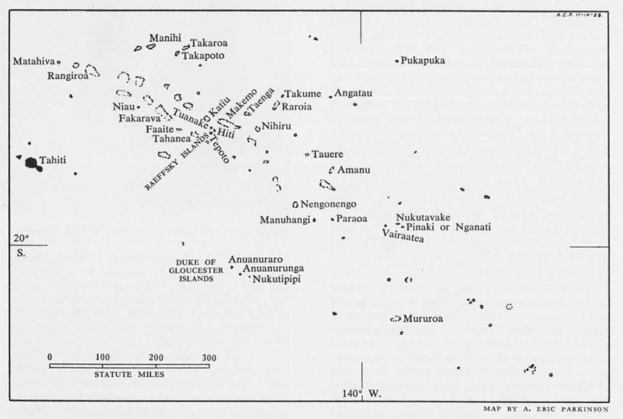
However, to return to the days before chronometers and cabbage, when longitude and scurvy were the main dilemmas facing Pacific sailors. The Dutch, of cours, had been knocking about the East Indies for a long time but did not turn their attention to the Pacific until the seventeenth century. The first important Dutch voyagers were the Le Maire and Schouten mentioned above. They sailed from Holland in 1615 in two ships, the Eendract and the Hoorn. Their first discoveries were in the Tuamotu (or Paumotu or Low or Dangerous) Islands. They had a tendency to give descriptive names to the islands they found: the first one, discovered on April 10, 1616, they named “Honden” (Dog) because the only inhabitants they found were three dogs (this island has been identified as Pukapuka). The next one they named “Sondergrondt” (Bottomless) because they could find no place to anchor (this is probably either Takaroa or Takapoto). When they found an island with fresh water they called it :Waterlandt” (now identified as Manihi). Later they encountered what may be the present Rangiora Island and bestowed the title “Vlieghen” on it because of the swarms of flies which followed their exploring boat back to the ship. Le Maire and Schouten discovered many of the northern Tongan islands, among them the present Niuatobutabu which they called “Verraders” (Traitors) because the natives attacked their ships. In 1767 the Englishman, Captain Samuel Wallis who had the honor of discovering Tahiti, found Niuatobutabu and nammed is “Keppel.” Like virtually every explorer to follow them, Le Maire and Schouten couldn’t resist naming some of their discoveries after one of their ships: they named the two islands of Alofi and Futuna, west of Samoa, after the Hoorn. Or were they named, as the ship was, after the town of Hoorn? Amazingly enough, these islands retain this name today, although the modern spelling is Horne.
The Dutch had very good luck in having the names they gave to their discoveries retained. Naturally there is more than luck involved: being excellent navigators they reported their positions with fair accuracy and their descriptions of the islands were quite good; also they discovered some isolated, or otherwise unique islands which are hard to mis-identify, and their maps and charts were rather widely circulated in other nations. Abel Tasman discovered New Zealand in 1642 and first called it “Staatenland” but later changed his mind and called it “Nova Zeeland.” Off the northern tip of New Zealand he found three islands on the eve of the Epiphany, so he named them Three Kings, again a name which has stuck. On January 5, 1643, he discovered the first of the Tonga Islands and named it “Pylstaart” (Tropic Bird), but today it is usually known by its native name Ata; as are Eua, which he named “Middleburgh,” and Tongatabu and Nomuka, which he named “Amsterdam” and “Rotterdam.”
The last great Dutch explorer in the Pacific, Jacob Roggeveen, also discovered and named an important island. He named it “Paaschen” or “Oster Eilandt” because he discovered it on Easter Day, April 6, 1772. We call it Easter Island, the Spanish call it Isla de Pascua, and the French Ile de Paques. It was also identified on early charts as Davis Land. Only the Easter Islanders have a different name for it– they called it “Te Pito o te honua,” which means the navel of the earth, or Land’s End; modern Easter Islanders call it Rapanui (Great Rapa), but this name was given to it by Tahitian sailors in the last century who thought it resembled Rapa in the Austral group.
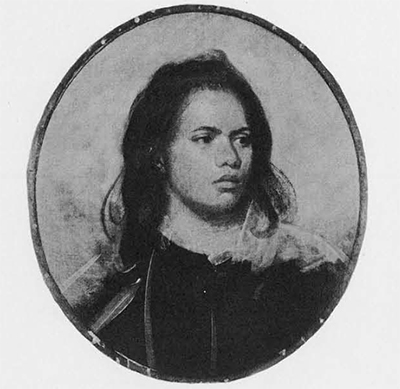
The Spanish navigators, some of whom were in the Pacific even earlier than the Dutch, did not have as much luck in having their discoveries identified or verified later. In fact, they probably “lost” more islands than they “found.” The most famous example is the Solomon Islands, which were lost for two hundred years. Now, the Solomons are not small, widely spaced islands; they are composed of ten large and many small islands, forming a double chain, extending northwest to southeast over nine hundred miles of ocean. The largest island is Bougainville which is one hundred twenty-seven miles long and has a maximum width of forty-nine miles. Six of the islands each contain a total land area of over one thousand square miles (Bougainville has 3,880 square miles). To find the discoverer of the Solomons we must turn to the first voyage of an explorer whose later career has already been discussed in the first article of this series, that is, the Spaniard, Alvaro Mendana de Neyra. Mendana, like most of his Spanish predecessors on land or at sea, was looking for gold: the object of his voyage was to discover rich lands and to convert the natives. I have already mentioned how he sailed across the Pacific on his first voyage without discovering any of the Polynesian islands. In fact, the only discoveries that can with any certainty be attributed to him are one of the southern Ellice Islands and perhaps Ontong Java (or Lord Howe). He finally had some success, however, when in February, 1568, he found a large mountainous island which he named Ysabel. One source says he named the island Ysabel for his wife; another source, however, reports the full name as “Santa Ysabel de la Estrella” or Saint Isabel of the Stars. Of course, it is possible that his wife was named for the saint, so he managed to include them both in his choice of a name. (Ysabel the island is also known as Bugotu, Bobotu, Camba, and Samba).
Mendana also discovered and named Guadalcanal and San Cristoval and members of his expedition found and named many more in the area. Convinced he had discovered the outposts of the famed, but partly mythical southern continent, Terra Australis, Mendana was extravagant in describing his discoveries to his compatriots in Peru and, perhaps to whet their interest with the suggestion of gold, he called his findings “Islas de Salomon.” Interest was slow in leading to action, so it was not until 1595 that Mendana was provided with a colonizing and exploring expedition– the one that discovered the Marquesas, that did not bring him back to the Solomons, but that resulted in his death and in the discovery of the Santa Cruz group. (His reckoning was so bad he briefly entertained the thought that the Marquesas were the Solomons when he first saw them!)
After Mendana’s discovery in 1568 the Solomons were not found again until 1767. The Spanish have been accused of deliberately withholding news of their discoveries, or of reporting them so vaguely that they could not be found by other voyagers. It is claimed that the journals of Gallego, Mendana’s pilot on the first expedition, and Quiros, the pilot on the second, were purposely suppressed. This may well be true, for at this point in history– the latter half of the sixteenth century– Spain in all of her colonial and navigational endeavors was being pressed by both Dutch and British, particularly by the latter, for this was the time of Drake’s very profitable venture into the Pacific after Spanish ships (and his consequent circumnavigation of the world) and the time of considerable pirate activity in the Caribbean and along the coasts of South America. Spanish navigators had reason to feel harried and to want to protect their discoveries.
After Mendana their only other important expedition for more than a century and a half was that of Quiros and de Torres in 1605-1606. Despite this limited activity Spanish influence is apparent in Pacific island names. The navigators all seem to have been of a religious turn, for saints were by far their favorite source of names. William Brigham, who compiled his Index to the Islands of the Pacific in 1900, lists thirty “Sans” and eight “Santas,” all attributable to the Spanish voyagers. This same author tried diligently to identify the various saints with known islands but was finally forced to note plaintively, “The saints of the old Spanish voyagers are harder to find on the charts than saints in real life.”
Although their exact location was uncertain, Mendana’s Solomon Islands became famous and they appear (in various parts of the South Pacific) on the early charts of every European nation interested in Pacific exploration. When other voyagers in the succeeding two centuries failed to find the Solomons their existence was doubted. However, in 1767 one of the most miserable ships ever to cross the Pacific stumbled onto the “lost” Solomons. This was the English ship Swallow, commanded by Captain Philip Carteret, and her story is interesting in itself.

“At 11 o’clock [on April 11, 1767] I would have shortened sail for the Swallow, but it was not in my power, for as a current set us strongly down upon the Isles of Direction [Narborough’s Islands], and the wind came from the west, it became absolutely necessary for me to carry sail, that I might clear them. Soon after we lost sight of the Swallow and never saw her afterward. At first I was inclined to have gone back into the streight, but a fog coming on, and the sea rising very fast, we were all of opinion that it was indispensable necessary to get an offing as soon as possible.”
On the same day Carteret rather wistfully recorded:
“At 1/2 past 6 [in the morning– the nautical day runs from noon to noon] saw the Dolphin W. 1/2 N., 8 leagues, with her studding sails set and a fresh breeze, and we only a light breeze and all the sail we could set.”
A few hours later Carteret had to back track because of the weather and by the afternoon of April 12th he must have realized Wallis’ intentions for he says:
“From this time I gave up all hope of seeing the Dolphin again till we should arrive in England, no plan of operation having been settled, nor any place of rendezvous appointed.”
(The quotations are from Appendix F, of the Hakluyt Society’s The Discovery of Tahiti: A Journal of the Second Voyage of H.M.S. Dolphin Round the World, under the Command of Captain Wallis, R.N., in the Years 1766, 1767 and 1768, written by her master George Robertson, Hugh Carrington, editor.)
It is hard to imagine how Wallis could have abandoned his “poor dull consort,” as she was labeled, but abandon her he did for he never turned back or waited for her and assumed she had been lost. The plucky Carteret might have turned back when he realized he had been deserted, but he probably didn’t want to face the Straits again, and perhaps his ire had been aroused at such treatment. His subsequent voyage across the Pacific and circumnavigation of the globe is rivaled for nerve, courage, endurance, and skill, only by William Bligh’s famous excursion in an open boat. Carteret, incidentally, discovered Pitcarin Island, named for the midshipman who sighted it, which, twenty years later became the haven of Bligh’s infamous mutineers. He also discovered Mururoa (named “Bishop of Osnaburghs Island”) and the “Duke of Gloucester Islands” (Nukutipipi, Anuanurunga, and Anuanuraro), all in the Tuamotus. Later Carteret happened on the Santa Cruz Islands and by sailing northwest from them found Ndai which he named “Gower Island” for his Lieutenant, and saw Malaita, both in the Solomons. Eventually, after a voyage of two years and seven months in the leaking tub, Carteret anchored the Swallow at Spithead, England a year after Wallis had returned. What Carteret said to Wallis when they met doesn’t seem to have been recorded.
Even though Carteret had found the Solomons again he didn’t identify them as such. Nor did the French navigator Louis de Bougainville, who passed Carteret in the Atlantic and marvelled that the Swallow could still float. Bougainville arrived in the Solomons in 176–a year after Carteret–found the island he named for himself and Choiseul Island, named for the Minister of France at the time. Another French explorer, M. de Surville, was there in 1769 and anchored off Ysabel, but he too did not realize he was in Mendana’s Solomon Islands. Finally in 1781 the last Spanish explorer in the Pacific, Don Francisco Antonio Maurelle, identified the Solomons as such. One night Maurelle discovered the dangerous reef south of the Lord Howe group and named it “El Roncador”– the Snorer–because of the noise of the waves breaking on it. Maurelle’s expedition was learned of in a rather curious fashion: his manuscript was procured in China (his voyage took him from Manila to St. Blaise on the North American coast) by La Perouse who sent it back to France with his own journals before he sailed off to his shipwreck in the Santa Cruz Islands. Thus ends the story of the Solomon Islands–lost for two hundred years and found again four times over before they were recognized.
It is interesting to read the journals of these early navigators and watch them at work naming their new discoveries. The journal of George Robertson, Master of the Dolphin, Carteret’s fast-sailing sister ship commanded by Wallis, records the naming of some islands in the Tuamotu Archipelago. The first they encountered is that called Pinaki or Nganati today; of it Robertson says on June 7, 1767:
“Before I left the Mast head I saw two canoes set out padling from this Island towards the oyther with three or four men in Each, this I Aquanted the Capt. off and he gave orders to hoist out the Barge and Cutter immediately–and Ordered the Secant Lieut. Mr. Furneux to take the Command of both Boats Mand and Armd–and to land and take possession of the Island in his Majst Name Calling it Whitesunday Island, this being the Day we took possession of it…”
On June 8th they followed the same procedure in taking possession of the island of Nukutavake but it was honored with the “Name of our Most Gratious Queen Charlote.” Three days later they found the modern Vairaatea (identified by Robertson’s editor as Pukarunga, but Pukarunga is the name of one of the islets on Vairaatea) and called it “Lord Egmonts Island.” The following day they entitled the present Paraoa “Duke of Glousters Island” (not to be confused with the group of islands, which are southwest of Paraoa, discovered by Carteret and given the same name). On the same day and on the next, June 13th, they found two more islands which together illustrate some of the discrepancies in naming that can occur. Robertson records of the first island, Manuhangi, that “the Capt. gave this the name of Prince William Henery Island,” and of the next, Nengonengo, that the “Capt. called it the Prince of Brunswick Island.” However, in his own journal Wallis states that the first island, Manuhangi was named “Cumberland Island” in honor of His Royal Highness the Duke, while Nengonengo he named “Prince William Henry,” and he didn’t name any of them Prince of Brunswick. The last island Wallis discovered was Mehetia or Meetia, the easternmost of the Society Islands which he named “Osnaburgh” (Robertson spells it Osnabrug), and again it is not to be confused with the island of Mururoa to the south which Carteret, with the same though in mind, named the “Bishop of Osnaburgh.” (The bishopric of Osnabruck was part of the inheritance of England’s Hanoverian kings, of whom George III was the third.)
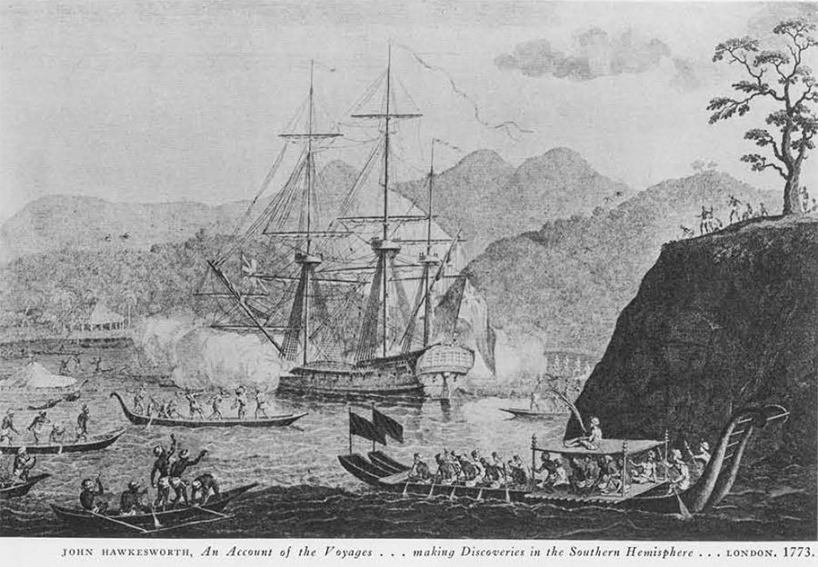
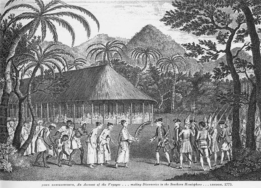
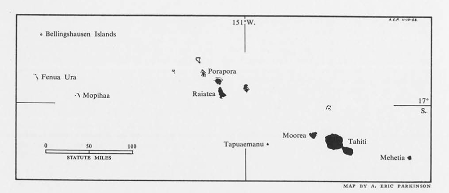
Wallis was certainly bent on commemorating important personages at home by naming islands for them. When, on June 26, 1767, he took possession of Tahiti, which he had discovered on June 18th, he “Honourd it with the name or our Most Gracious sovereign King George the third.” Tahiti’s sister island, now called Moorea or Eimeo, Wallis called “Duke of York.” After leaving Tahiti he made three more discoveries in the Society Islands: Tubuai Manu, (Tapu-a-manu, Tapuaemanu) which he named “Sir Charles Saunders” (Robertson makes another slip here for he reports it Sir John Saunders); “Howe” or “Lord Howe Islands” (now known as Mopihaa or Mopelia), and Fenua Ura which he called “Scilly Islands.” From there Wallis went on to the northern Tonga Islands where, as previously mentioned, he named Nuiatobutabu, called “Traitors” by Le Maire and Schouten, “Keppel” (spelled Keples by Robertson) and Tafahi (called “Cocos” by the two Dutchmen) he dubbed “Boscawen.” Three days later on August 16th, the Dolphin came across Uvea (or Uea) which her crew named “Wallis” after their captain. From here they sailed northwest past the Ellice and Gilbert Islands, apparently without discovering any of them, to Tinian in the Marianas and finally out of the Pacific to Batavia and eventually England.
Suppose we consider briefly Wallis’ main discovery, Tahiti. He named it, as noted, “King George III’s Island.” The next explorer to find it was the Frenchman, Louis de Bougainville, who first sighted it on April 2, 1768, scarcely ten months after Wallis had been there. Naturally, Bougainville didn’t know of Wallis’ voyage so he claimed Tahiti as a new discovery. Later, he was not reluctant to relinquish his claim because he got into a bitter controversy with Wallis over whose expedition had introduced venereal disease on Tahiti. This clash almost assumed international importance. Wallis wrote in his own defense (quoted in an Appendix to Robertson’s journal):
“The reproach of having contaminated that dreadful pest a race of happy people, to whom its miseries had till then been unknown, must be due either to him or to me, to England or to France; I think myself happy to be able to exculpate myself and my country beyond the possibility of doubt.”
The surgeon on Wallis’ ship had last treated the crew fo disease when they were in the Straits of Magellan, almost six months before they arrived at Tahiti. On this basis Wallis defends his countrymen, but Bougainville also thought his two ships were free of the disease. This controversy went on in successive edition of their respectful voyages, and it wasn’t helped a bit when Cook, on his second voyage to Tahiti in 1773, records the Tahitians’ term for the disease as Apa no Pretane or the English disease, although he goes on to say that the Tahitians claim it was brought by Bougainville, whom they thought came from Britain, too. The question is still not settled since some doctors today consider it a possibility that the disease preceded European contact (because syphilis is so closely related to yaws which was certainly an endemic disease). Suffice it to say, that Wallis and the Dolphin’s crew were there first, but one has to read Bougainville’s journal to realize why he named the island “La Nouvelle Cythere”– the new Aphrodite!

Cook, knowing of Wallis’ names, continued to call Tahiti “King George III Island” officially, but more often than not he refers to it in his journals as Otaheite, including what was probably the intensive prefix “O” meaning “it is” with the actual native name of the island. Betweek Cook’s first and second voyages, there was a Spanish expedition to Tahiti to survey it for a possible colony. This was the voyage of Don Domingo Boenechea from Callao, Peru; he gave the island still another name–“Isla d’Amat,” in honor of Don Manuel de Amat, the Viceroy of Chile and Peru. He also renamed Moorea, “Santa Domingo.”
Miss Stoller will continue her story of the Pacific Islands exploration in a future number of Expedition.