(The Libyans] schemed to plot rebellion a second time, to finish their lifetime on the frontier of Egypt. They gathered the hill-countries and plains of their district. They laid death upon themselves [by coming] against Egypt…
(Records of Ramesses III, translated by Edgerton and Wilson 1936:91)

From O. Bates 1914: Pl. 3. Reproduced by permission of Macmillan Publishers Ltd., London)
Introduction
During the Mediterranean Bronze Age (ca. 2000 to 1000 B.C.) the Libyans were well known to Pharaonic Egypt, appearing frequently in Egyptian texts, reliefs and wall-paintings (Fig. 1). As the opening quote indicates, during the late 2nd millennium B.C. the Egyptians were very much concerned with the migration of large numbers of these tribal people towards the Nile Delta, where they sometimes engaged in battle with the armies of the Pharaoh (see O’Connor, this issue). But until recently, archaeologists have barely been able to trace even the simple fact of the Libyans’ existence within northeast Africa. Thus, possessing only the highly selective Egyptian material (as well as other problematic forms of evidence), scholars have generally been unable to draw firm conclusions about Libyan cultural characteristics and foreign relations.
University Museum Expedition to Marsa Matruh)
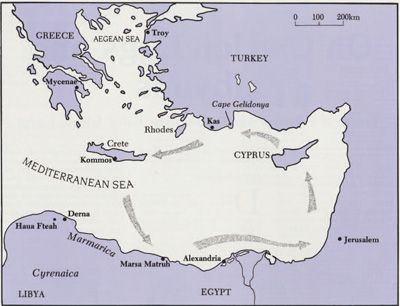
The University Museum’s search for the Bronze Age Libyans began twenty-five years ago, when it sent an exploratory expedition to Cyrenaica (Fig. 2). Unfortunately, no archaeological evidence dating to the Bronze Age was found (Carter 1963). More recently, a team sponsored by the Museum began excavating in northwest Egypt, aiming to add to such knowledge as we have about the ancient Libyans’ way of life. The expedition is led by Dr. Donald White, Professor of Classical Archaeology and Curator of the Mediterranean Section in The University Museum.
Basing his research on the largely forgotten work of Oric Bates, an American archaeologist and ethnologist working for Harvard’s Peabody Museum in the early 1900s, White identified a Bronze Age settlement site on a small island near the modern town of Marsa Matruh (ancient Paraetonium). The first season of excavation took place in the summer of 1985, with fieldwork continuing in June and July of 1987. The islet, known locally as both the “Island of the Jew” and “Desert Island,” has been renamed “Bates’ Island” in honor of the man who first suspected its archaeological importance.
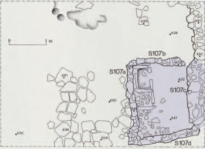
While the work of the Marsa Matruh Expedition is still at a preliminary stage, a wide range of material from the 14th century B.C. has been recovered. Excavation has exposed the remains of semi-permanent buildings with stone foundations (Fig. 3). Most of the domestic pottery from this period is apparently of Cypriot origin, but other vessels were imported from Minoan Crete, Mycenaean Greece, and the Levant. Most recently, substantial quantities of Pharaonic Egyptian pottery have been identified.
This settlement also yielded nearly 50 small fragments of ostrich eggshell, and it is these bits of shell that may provide our first material evidence of the Bronze Age Libyans (White 1986: 79, n.71; 82). They also serve as a starting point for a reassessment of our understanding of life on the northeast coast of Africa during the Late Bronze Age, and the Libyans’ relationships with non-Egyptian foreigners. As this essay was substantially completed before the 1987 season of excavations, the focus throughout is on material found in 1985. The archaeological evidence from 1987 supports the conclusions made here.
Bates’ Island and Marmarica
(After a drawing by the University Museum Expedition to Marsa Matruh)
University Museum Expedition to Marsa Matruh; photo by D. White)
The resort town of Marsa Matruh is located at the eastern limit of the rugged Marmaric coast. According to most conventional definitions, Marmarica ran west from Matruh to Derna in eastern Cyrenaica, and was sandwiched between the Mediterranean Sea and Egypt’s Western Desert directly to the south. Today the eastern Marmaric coast is a semi-arid zone, and while its terrain is barren and forbidding at the height of summer, this coastal strip is potentially fertile, especially around Marsa Matruh.
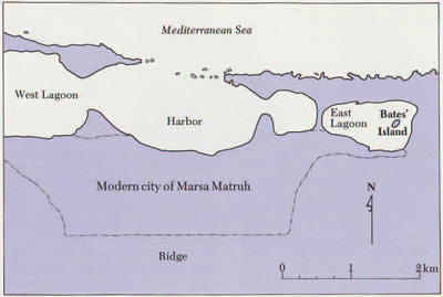
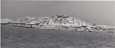
Bates’ Island lies at the eastern end of Matruh’s first East Lagoon (Figs. 4, 5). This islet is small in size, about 135 m long by 55 m wide. A low sandstone coastal ridge separates the lagoon system from the Mediterranean Sea just to the north. Composed mainly of hardened layers of coarse sand atop bedrock, the island lacks any true soil cover, is bare of vegetation except for a limited range of low scrub, and has no source of fresh water. Though the site may have been connected to the mainland to the east during its Roman-period occupation, preliminary observations indicate that it was an island in the Late Bronze Age. It is even possible that the lagoon’s waters were somewhat higher at that time than they are today. While a higher sea level would have reduced the size of Bates’ Island, it might also have made the more easterly portions of Matruh’s lagoon system accessible to incoming ships (White 1986: 61-2).
Late Bronze Age Libyans
In order to clarify the importance of our new archaeological traces of the Libyans, it is useful to summarize first our current understanding of their way of life in the Late Bronze Age. Analogy with present day tribal groups living along the northeast African coast forms an important source for our understanding of the ancient Libyans. Our best evidence, however, is drawn from the textual and pictorial records left by the Pharaonic Egyptians, even though these were both highly selective in their subject matter and biased in favor of the Pharaohs.

(University Museum Expedition to Marsa Matruh; photo by D. White)
The climate of northeast Africa has remained essentially stable since the end of the 3rd millennium B.C., when the Sahara as a whole had reached its present aridity. Therefore the 14th century B.C. residents of the Marmaric coast must have adapted to a limited range of resources very much like those presently existing in this marginal climatic zone. Currently the Marmaric coastal zone possesses a drier variant of the usual Mediterranean climate, with a seven- to eight-month warm, dry season and a shorter mild, rainy season which lasts, generally, from November to March.
The modern rural inhabitants of Marmarica are mostly members of the Awlad Aly tribe of the Bedouin, who number about 150,000. While these traditionally nomadic people are currently turning to a more sedentary way of life, in the past they usually practiced a shifting form of land use involving transhumance—the seasonal movement of some or all of the group. Their economic system emphasized herding, supplemented by small-scale agriculture. Permanent settlements were rarely established. This mixed economy is a response to the region’s marginal climate, in which the frequency and force of the rains can vary widely from one year to the next. In such a situation, the local population must diversify its economic base so as not to be wholly dependent on any one particular resource.
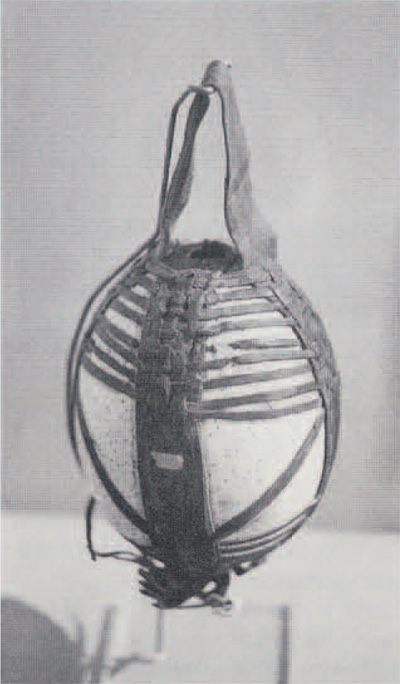
(This example the property of the Somali National Museum, Mogadishu, was shown in the exhibition “Somalia in Word and Image,” held at the University of Pennsylvania’s Arthur Ross Gallery, Dec. 7, 1985-Feb. 9, 1986.)
The traditional yearly cycle of movement of the Bedouin can be summarized as follows. After the first rains in November, they sow cereal crops, particularly barley, in the cultivable strip of land along the coast. The young men then move inland with the flocks to the pasture in the south that is available only during the wintertime. Older Bedouin remain behind to tend the fields. As the rainy winter months pass by, the men in the south gradually move their flocks back towards the coast, reaching the northern coastal zone by April. By this time, the rains have ended and the crops have been harvested. Thereafter the various clans of the Bedouin concentrate in large temporary encampments near the Mediterranean for the duration of the dry summer months, grazing their animals on the sparse forage remaining in the harvested fields.
In order to maintain an economy based mainly on agriculture in this region, the semi-arid environment must be modified to provide water for the crops in critical periods. As far as we know techniques such as irrigation and water catchment were not used during Bronze Age times in northeast Africa, and were adopted only after the arrival of the Greeks in Cyrenaica in the later 7th century B.C. This hydraulic technology was eventually abandoned, and the area’s agriculturalists have only recently learned once again how to lessen their dependence on rainfall.
A reconstruction of the Bronze Age Libyans’ way of life need not, however, rely solely on analogy with modern conditions. While the Libyans produced no written documents of their own, Egyptian New Kingdom sources (1552-1069 B.C.) document important aspects of Libyan culture. In the first place, they confirm the supposition that herding was an essential aspect of Late Bronze Age Libyan economy. We have, for example, references to very large numbers of cattle, sheep, goats, and asses which the Egyptians had captured from the Libyans. Ramesses III (1184-1153 B.C.) claimed to have taken as booty almost 43,000 animals following his defeat of the Libyans in his second war with them (Edgerton and Wilson 1936: 87-8). Second, written records confirm that Libyan society was indeed tribally organized, with kin groups led by hereditary chiefs inhabiting clearly defined geographic areas (see O’Connor, this issue). Further, Egyptian documents show that the Libyans possessed a well-developed military apparatus over which a single leader exercised supreme control when the tribes were allied. Finally, fixed settlements apparently existed among the ancient Libyans, and at least some of these people seem to have engaged in trade with the outside world. (For a more complete review of the points treated here see O’Connor, forthcoming.)
Limited archaeological evidence supports much of this general and incomplete picture of life among the Late Bronze Age Libyans. Digging in Cyrenaica, directly west of Marmarica, the late British prehistorian C.B.M. McBurney discovered deposits dated to the 3rd and 2nd millennium B.C. in the cave shelter at Haua Fteah (Fig. 2; McBurney 1987). Though he could not fully document the material culture of the cave’s occupants, McBurney did identify the presence there of coastal herdsmen, who used pottery, stone tools, and more rarely, metal imports. Interestingly enough, the artifacts gave little indication of contact between this particular group of Libyans and Pharaonic Egypt. This is contrary to what we might have expected, given the prominence of certain Libyan tribes in Egyptian texts and reliefs.
To summarize, when excavations began at Bates Island, we had a general picture of Late Bronze Age Libyan life. The peoples residing in the semi-arid coastal zone around Marsa Matruh would have been members of a semi-nomadic tribe, who moved with the seasons to take advantage of widely scattered resources. Their economy would have been based mainly on pastoralism, supplemented by small-scale agriculture. Though basically self-sufficient, these Libyans probably engaged in some trade with other peoples. Relations with foreigners might have been dominated by the Libyans’ interaction with their powerful and wealthy neighbor to the east—Pharaonic Egypt—although McBurney’s finds in Cyrenaica would caution against that assumption.
Ostrich Eggshell From Bates’ Island
The distribution of ostriches was much broader in the past than it is today, extending in Bronze Age times from North Africa, across the Middle East, to the Far East. In Egypt, they persisted as late as the end of the 19th century. Given the presence of such birds in the coastal region near Bates’ Island in antiquity, it seems highly likely that the shells recovered from this small isolated outpost were obtained locally, rather than from more distant regions.
Seven of the fifteen ostrich eggshell fragments found on Bates’ Island in 1985 occurred in pure Bronze Age strata dated to the 14th century B.C. The remaining fragments were found in disturbed Late Bronze Age contexts or in Roman, Islamic, or surface deposits. An additional 33 pieces with a similar broad chronological distribution were recovered in 1987. The shell fragments from late levels may document the continuing use of such eggs, but they could also have been derived from Bronze Age strata which were disturbed in later times (for example, by the digging of pits or construction activities).
We found no complete eggs, and the excavated fragments are rather small, with their surface areas usually varying from 1 to 3 mm by 1 to 2 mm; our largest piece is about 6 by 7 mm (Fig. 6). All the eggshells are about 2 mm thick. Given the small size of the whole collection, the fragments exhibit a wide range of color, varying from deep reddish brown to tan. Such variations in color among bits of shell, present even on examples from the same habitation phase, presumably result from varying degrees of weathering. Differential weathering would also explain the condition of the shells’ surfaces: while some of the fragments are very smooth, others are more unevenly preserved, with some portions of their surfaces substantially eroded away. The shells preserve no evidence of incised decoration or painting, and all edges appear to be the result of random breakage.
Though we cannot be entirely certain of the function of ostrich eggs at the site because the preserved fragments are small and relatively few in number, we might suppose that they served one or more utilitarian purposes. They are probably the remains of eggs used as food (see box), or as canteens which might have been slung from a harness of leather or rope (Fig. 7).
Taken in isolation, these fragments of common everyday objects are interesting, but not very significant for the historian. They are, however, potentially of great importance for two reasons. First, the Egyptians portrayed Libyans bring ing ostrich eggs as their special gift to the king—a gift that was presumably the most desirable of the products of their lands (Fig. 12). The shells at Bates’ Island may have been brought to the island by Libyans, supplying material evidence of their presence in the area. Second, since ostrich eggs were traded around the eastern Mediterranean during the Late Bronze Age, our ostrich egg fragments could also be important remnants of trade between the Libyans and foreigners.
The Ancient Residents of Bates’ Island
The 14th-century B.C. occupation on Bates’ Island was contemporary with the ill-understood beginning of an extended period of armed confrontation and large-scale Libyan movement east into the Nile Delta region (see O’Connor, this issue). By the later 13th and early 12th centuries, migrating Libyan tribes were mounting major threats to Egyptian security, engaging in battle with Egypt on at least three occasions (O’Connor: Fig. 5). Bates’ Island, by virtue of its geographic location, would necessarily have played a part in any significant regional developments during the 14th century.
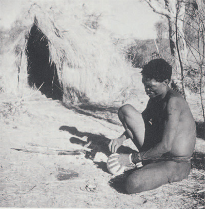
Photo taken in 1951 by R.H. Dyson, Jr., in Gautsch Pan, southwest Africa.
Questions such as the overall role of Bates’ Island in Late Bronze Age events, the precise nature of activities there, and the significance of fragmentary ostrich eggshell in such activities are all inevitably linked with the identification of the people who were using the site. The Libyans surely knew the islet, and could conceivably have lived on it themselves, but this need not have been the case. Might the Pharaohs have located a small military outpost here, as they did during the next century at Umm El Rakham just to the west of Marsa Matruh? Or could the site’s occupants have been foreigners, part of a network of trading posts placed at strategic locations along the Mediterranean shores?
Despite the newly recognized presence of 14th century Egyptian pottery, we can probably eliminate the Egyptians as actual residents on the island, since there are no inscriptions or other conventional traces of their official presence. The greater likelihood is that these ceramic vessels were acquired by Libyans—either in the Delta region to the west, or in the Kharga, Dakhla or Bhariya oases further south—and then brought to the island for exchange with its foreign occupants. It is not yet clear how far Pharaonic control extended to the west during the 14th century B.C., but based on the available evidence we still believe that Bates’ Island (like the cave at Haua Fteah) may have been outside the Egyptian sphere of influence until the settlement of Umm El Rakham in the time of Ramesses II.
The question of resident Libyans is more complex. A group of burials on the limestone ridge south of the islet were excavated by Oric Bates. These have been interpreted as early Libyan (White 1986:56, 82), providing tangible evidence of their presence in the general region of the site. The problem here is that the artifacts found with these burials were apparently lost following Bates’ premature death in 1918. As a result, it is difficult if not impossible to determine the precise date of the graves.
It has been suggested here that the fragments of ostrich eggshell found at Bates’ Island are remnants of eggs brought from the mainland by members of a local Libyan population. Other evidence of contact between the latter and the island settlement is provided by two types of pottery tentatively believed to be of Libyan manufacture. The first type, represented by less than half a dozen sherds, is of a coarse, heavy, black handmade ware that has been found only on Bates’ Island. The second type is light brownish-gray in color, and has numerous conspicuous bits of shell within the clay fabric; the surface is decorated with simple linear incisions. This so-called “Shell Tempered Ware” was discovered by the 1987 expedition at a variety of sites on the slopes of the low hills overlooking Bates’ Island. While such sherds are abundant on the mainland, only four pieces have been recovered from the island. We await the dating of this pottery by laboratory thermoluminescence testing. If it does prove to be ancient (that is, Bronze Age in date), Shell Tempered Ware would appear to mark the location of the seasonal encampments of the Libyans. Accordingly, we might infer that the Libyans did not occupy the island themselves, but instead established temporary campsites nearby in order to trade with its non-Egyptian (and non-Libyan) occupants.
Pottery also provides the rather specific evidence as to who the islanders were: in contrast with the paucity of material of North African origin, the excavations recovered an abundance of pottery manufactured outside of Egypt, with Cyprus as the main source (Fig. 13a, b). Various Cypriote “fine wares” are well represented, but it is the high proportion of coarse ware sherds, some of which belonged to very large storage and cooking vessels, which indicates that the small settlement was supplied and perhaps settled by Cypriotes. Another intriguing indication that foreign peoples used the site is the evidence that metalworking took place there. On the assumption that this skill was not likely to have been known to the nomadic Libyans, the Bates’ Island bronze-workers must have been foreigners.
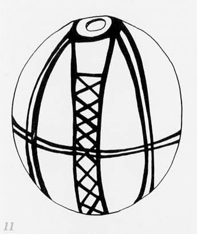
From Caubet 1983: Fig. 3. Reproduced by permission of the Dept. of Antiquities, Cyprus)
Combining our physical evidence of foreign residents on Bates’ Island with our understanding of Late Bronze Age trade in the eastern Mediterranean, we may suggest a function for the site: in the 14th century it probably served as a revictualing station for passing merchant ships (White 1986: 83-4). The protected geographic location of the site, remote from other settlements in an area with an inhospitable climate, probably invited visits by foreign merchants. The northeast African coast is almost completely without well-protected harbors, and the lagoon system at Marsa Matruh is virtually the only serviceable harbor between Tobruk and Alexandria.
Bronze Age merchant vessels traveling between east Mediterranean ports doubtless sailed during the summer months when conditions were favorable; at this season they would have followed a counterclockwise circuit, in accordance with the prevailing summer winds and water currents (Fig. 2; White 1986:83-4). Having set out from Crete on the southern leg of their voyage, merchants would have found at Marsa Matruh the first large, well-protected harbor after the relatively long open-sea voyage to northeast Africa. Here at Bates’ Island they would have been able to replenish their supplies before sailing to their home ports or on to more lucrative stops in Pharaonic Egypt and the Levant. The station was presumably staffed by a small crew of foreigners, perhaps Cypriotes, who lived on the islet during the spring to fall sailing season, protected by an expanse of water from the potentially hostile Libyan population of the mainland.
This picture of the character of trade in the east Mediterranean in the Late Bronze Age and Bates’ Island’s place in that trade is in part hypothetical, but is strongly supported by a growing body of archaeological evidence. Recent decades have brought to light physical evidence for the international trade route in the form of wrecked ships and the ports they sailed from.
In the 1960s, a University Museum expedition led by Dr. George Bass excavated a merchant ship which sank off Cape Gelidonya on the southern Turkish coast about 1200 B.C. This ship apparently went down after leaving Cyprus, in the midst of its rounds of the east Mediterranean trading stations as shown by its cargo of pottery from various lands bordering that sea.
While the Gelidonya wreck postdates the occupation of Bates’ Island by as many as two centuries, Bass is presently directing the ex cavation of a ship of similar character which sank near the modern Turkish port of Km (Cape Ulu Burun) in the 14th century B.C.contemporary with the island settlement off the Libyan coast. The Ka§ ship had already visited various ports throughout the eastern Mediterranean, since Cypriote, Syro-Palestinian, and Mycenaean pottery were on board when it went down—as were two complete ostrich shells (Fig. 14; see also Bass 1987).

From N. de Davies 1905: Pl. 40
At least one example of a major Bronze Age seaport has been found, at Kommos on the southern coast of Crete (Fig. 2). Recent research at this Minoan site has yielded tangible evidence for that island’s participation in east Mediterranean trade during the 14th century, including an international range of pottery analogous to that found on the Ka§ ship (as well as at Bates’ Island). In fact, it has been suggested the Km ship with its rich cargo may have been destined to unload the bulk of its wares in Crete (Pulak 1988).
Thus the Kas and Gelidonya wrecks, Kommos, and Bates’ Island reflect different aspects of one phenomenon: the trading operations which linked the Aegean and the Near East during the Late Bronze Age. Between major ports and trading centers, ships would have stopped off at remote but well-placed sites like Bates’ Island, where their crews could have exchanged pottery and metal implements for shelter and basic supplies (see below).
In this scenario, the seasonal residents of Bates’ Island, as well as the foreign mariners anchored nearby at any given time, would have engaged in trade with semi-nomads who were living in the adjacent coastal area for the summer months. While imported pottery may have been part of these commercial relations with the Libyans, the foreigners had another valuable product to offer—knowledge of an advanced technology. We must presume that bronze objects, produced by methods unknown to the Libyans, were an important part of the trade between the Libyans and the people who used the island.
Exactly who the metal workers on Bates’ Island were is an interesting question. On the basis of his finds at Cape Gelidonya, Bass has shown that itinerant bronzeworkers traveled aboard Late Bronze Age merchant ships, equipped to supply their products on demand in each port of call. Thus bronze working may have been performed either by a Bates’ Island resident, or by a craftsman from a passing ship.
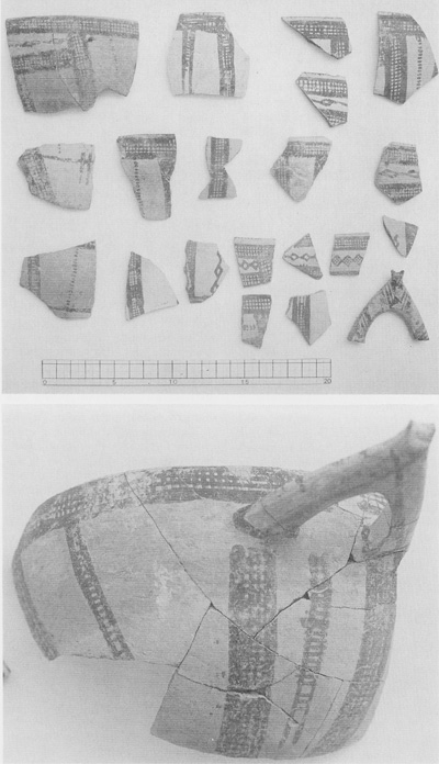
University Museum Expedition to Marsa Matruh; photo by D. White)
The Libyans living near the revictualing station on the islet could have traded various items in return for the pottery and bronze objects. At such an isolated outpost, and given the needs of passing merchant ships, local resources must have been the primary trade goods, including water (of which there was none on Bates’ Island itself), meat, and various other foodstuffs and wild animal products—including ostrich eggs. Perhaps consumed at the site, these eggs also could have been carried off by the visiting merchants to be traded as novelties in other ports, eventually to be transformed into rhyta, dedicated in foreign sanctuaries, or offered in tombs in distant lands (see box on ostrich eggs).
Conclusion
Though in the past it has been suggested that people from the Aegean settled on the northeast African coast during the Bronze Age, no convincing tangible evidence has yet been furnished which would prove this hypothesis. Excavations by The University Museum on Bates’ Island have begun to provide material evidence which will help us to understand African-Aegean relationships in the Late Bronze Age. Most importantly, the site is yielding tangible evidence of interaction between Libyans and foreigners during the late second millennium B.C.
Abou-Zeid, A. M. 1959
‘The Sedenterization of Nomads in the Western Desert of Egypt.” International Social Science Journal 11(41:550-8.
Bass, G. F.
1967
Cape Gelidonya: A Bronze Age Shipwreck. Transactions of the American Philosophical Society, New Series, Vol. 57, Part 8. Philadelphia: American Philosophical Society.
1987
“Oldest Known Shipwreck Reveals Bronze Age Splendors.” National Geographic 172(6):693-733.
Bates, 0. 1914
The Eastern Libyans: A Essay. London: Macmillan.
1927
“Excavations at Marsa Matruh.” Harvard African Studies 8:125-97
Behnke, R. H., Jr.
1980
The Herders of Cyrenaica: Ecology, Economy, and Kinship among the Bedouin of Eastern Libya. Illinois Studies in Anthropology No. 12. Urbana: University of Illinois Press.
Carter, T. H.
1983
“Reconnaissance in Cyrenaica.” Expedition 5(3):18-27.
Caubet, A. 1983
“Les oeufs d’autruche au Proche Orient ancien.” Report of the Department of Antiquities, Cyprus:193-8.
Davies, N. de G.
1905
The Rock Tombs of El Amarna, Pt. 2. Archaeological Survey of Egypt, Memoir 14. London: Egypt Exploration Fund.
Edgerton, W. F., and J. A. Wilson
1938
Historical Records of Ramses III. Oriental Institute, Studies in Ancient Oriental Civilization, No. 12. Chicago: University of Chicago Press.
Finet, A.
1983
“L’oeuf d’autruche.” In Studio Paulo Nester, 2: Orlentalia Antigua, ed. Quaegebeur, 69-77. Leuven: Witgeverig Peeters, Departement Orientalistiek.
Francis, P.
1987
“Bead Report XX: Another Bead Potpourri.”Ornament (3):62f f.
Knapp, A. B.
1981
“The Thera Frescoes and the Question of Aegean Contact with Libya during the Late Bronze Age. Journal of Mediterranean Anthropology and Archaeology 1:249-79.
Laufer, B.
1928
Ostrich Egg-Shell Cups of Mesopotamia and the Ostrich in Ancient and Modern Times. Field Museum of Natural History, Anthropology Leaflet No. 23. Chicago: Field Museum of Natural History.
MeBumey, C. B. M.
1967
The Haua Fteah (Cyrenaica) and the Stone Age of the Southeast Mediterranean. Cambridge: University Press.
O’Connor, D.
1983
“New Kingdom and Third Intermediate Period, 1552-664 B. C.” In Ancient Egypt: A Social History, ed. B. G. Trigger at al., 183-278. Cambridge: University Press.
Forthcoming
“The Nature of Tjemhu (Libyan) Society in the Later New Kingdom.” In Libyans in Egypt in the First Millennium B. C.. ed. A. Leahy.
Pulak, C.
1988
“The Bronze Age Shipwreck at Ulu Burun, Turkey: 1985 Campaign.” American Journal of Archaeology 92:1-37.
Reese, D. S.
1986
“The Kition Ostrich Eggshells… In Excavations at Kition. The Pre-Phoenician Levels, Part 2, ed. V. Karageorghis and M. Demas, 371-82. Nicosia: Department of Antiquities.
Shaw, J. W.
1986
“Excavations at Kommos (Crete) During 1984-1985.” Hesperia 55:219-69.
White, D.
1986
“1985 Excavations on Bates’ Island, Marsa Matruh.” Journal of the American Research Center in Egypt 23:51-84.
