The geography of the Middle East provided both challenges and opportunities for the people who lived there. Most of the Middle East is characterized by a Mediterranean-influenced climate, with cool or cold, wet winters and dry, hot summers. This climate pattern was established by the end of the Ice Age (10,000 BCE). Over the past 12,000 years, the climate has fluctuated.
Reconfiguring the Surrounding Landscape
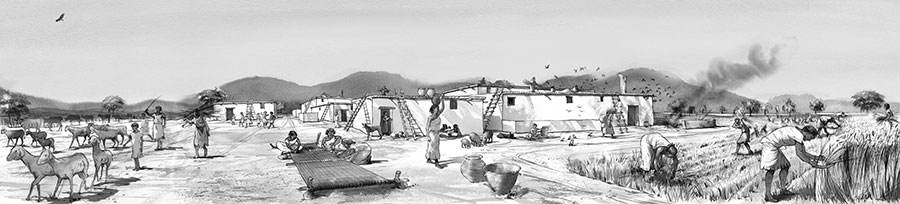
People adapted to existing environmental conditions, but they also changed the landscape in which they lived. Even before they began to cultivate plants and keep herds, communities in parts of the Middle East began to live year-round or nearly year-round in small settlements. Archaeologists have found traces of round stone structures, some residential and some ritual. These small sedentary communities developed ways of preserving and storing foods from wild plants and animals; storage pits became common, but containers made of clay did not appear until about 7000 BCE (and were not widespread until about 6000 BCE). As agriculture and related technologies spread, populations grew, and human activity played an increasing role in shaping the land.
Earliest Plant and Animal Domestication
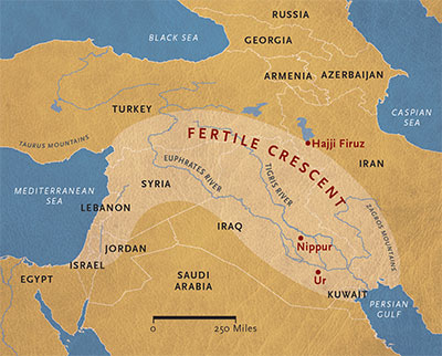
After plants and animals were domesticated at the outer edge of Mesopotamia, agriculture spread to the lowlands, where the first cities arose. This region was first called the “Fertile Crescent” in 1916 by archaeologist James Henry Breasted.
Innovations in the Four Sub-Regions
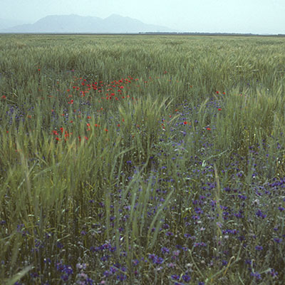
Most of the material in the Middle East Galleries comes from the Penn Museum’s projects in present-day Iraq and Iran. This region has always had broad cultural connections that extend from Turkey in the west to Afghanistan in the east. We have, therefore, defined several regions that are distinguished by long-standing natural and cultural features. We begin in the foothill zone of the Taurus-Zagros arc, the outer edge of the “Fertile Crescent.” This region of steppe and steppe-forest, with its natural vegetation cover of grassland and open woodland, saw the earliest experiments in plant cultivation and animal herding. Favored with precipitation exceeding 10 inches (250 mm) per year, it is possible to farm here without supplemental irrigation.
The first farmers began to cultivate locally available plants—wild cereals, like einkorn and emmer wheats and barley, wild pulses like lentils, chickpeas, peas, and bitter vetch, and wild flax, grown initially for fiber. Dogs had long accompanied the hunting and foraging peoples of the ancient Near East, but they were not eaten. The ancestors of the earliest domesticated food animals— sheep, goat, cattle, and pig—are native to this part of the world. It took about a thousand years for the different pieces of the Middle Eastern farming system to come together. Once established in the foothill zone, agriculture spread to the lowlands of the Tigris and Euphrates valleys, the region archaeologists call Mesopotamia.
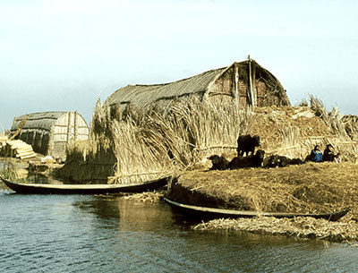
The first settlers in lower Mesopotamia (ca. 6000 BCE) encountered marshland inhabited by fish and migratory birds at the head of the Persian Gulf and lowland steppe with rich winter pasture away from the sea. Wood was scarce, as the only trees grew along the rivers, and stone was almost entirely absent. Thus, the marsh dwellers lived in houses made of reed bundles, while the inhabitants of the dryland steppe built structures of sun-dried mudbrick. Annual rainfall was, and still is, insufficient for dry-farming in this zone, so fields have always been irrigated here. Initially important for irrigation, the Tigris and Euphrates Rivers and their tributaries became important routes of trade, communication, and transport of goods. The climate in this region is warm enough for the date palm, which was domesticated by 4000 BCE. Some of the earliest cities, such as Ubaid and Ur, were established in the marshy areas. Others, like Nippur, were in the drylands.
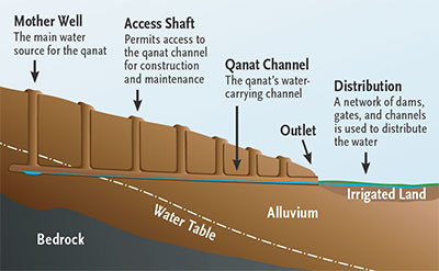
By 6000 BCE at the latest, agricultural practices spread to the Iranian Plateau. This region is characterized by virtually uninhabitable central deserts surrounded by moister uplands, which support rain-fed farming or irrigation agriculture. In the 1st millennium BCE, this region saw the development of qanats, a kind of irrigation that brings groundwater from higher elevations to fields by means of built underground channels; the wealth of Medieval sites like Rayy depended on heavy investment in irrigation infrastructure. This region is rich in stone and metal, and upland sites such as Tepe Hissar show there were trade routes between the Mesopotamian lowlands and points east.
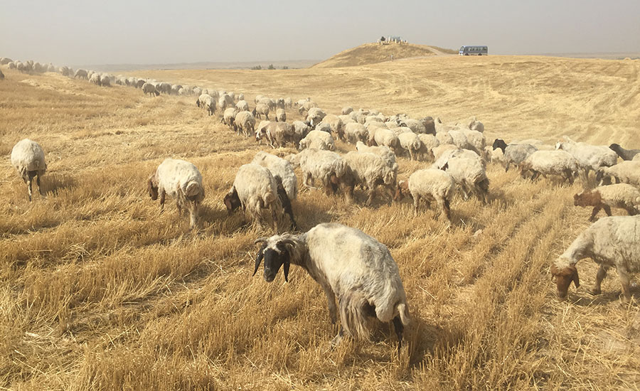
The fourth sub-region is the Zagros Mountains, which separates the foothill zone and Mesopotamia from the upland plateau. The mountain slopes support open woodland of oak in the moister north and pistachio and almond trees to the south. The flat valleys are suitable for dry-farming. Some of the peoples of the Zagros Mountains became primarily dependent on herding and moved annually to take advantage of winter pasture in the warm lowlands and summer pasture in the cooler highlands. Traces of their passage are hard to find, but remnants of their presence can be found in Luristan (western Iran).

Later Developments
Even before agriculture, food storage and food preservation technologies had not only tided communities over the winter, but made it worthwhile to generate a surplus of food. The fermentation processes that produced wine from wild grapes at Hajji Firuz (northwestern Iran) made sour grapes potable; people may have discovered how vinegar pickles vegetables. Communities also learned how to ferment grain for beer. Over the course of the next two millennia—from about 5000 to 3000 BCE— the domestication of grapes and tree fruits, like date, olive, and fig, added nutritional and culinary variety to the menu. In Mesopotamia, the date palm became a staple crop for rich and poor alike.
After about 6000 BCE in areas marginal or impossible for rain-fed farming, people learned how to irrigate crops. With the development of trade and communication networks across Eurasia, new crops that had been domesticated outside the Near East were introduced. Many of them, like millet and rice, could be grown only in the summer under irrigation. By the 7th century CE, a variety of other warm-season crops, such as cotton, sorghum, lime, and sugar cane, were added to the repertoire. It was not until the European Age of Discovery in the 16th century CE that tomato, potato, tobacco, and other crops from the Americas became integrated into Middle Eastern cuisine and lifestyle.
Changes in animal husbandry proceeded alongside developments in farming. People had long used animal dung as a fuel source to supplement wood, but new animal breeds yielded milk—which could be turned into a variety of storable dairy products, with the help of microorganisms like yogurt bacteria and cheese microbes— and wool, which soon dominated textile production. Oxen were harnessed to the plow, which allowed farmers to cultivate more land. Other domesticated animals, such as the donkey, horse, and camel (the one-humped dromedary and the two-humped Bactrian camel) came into the Middle East from elsewhere. The introduction of these animals, able to carry heavy loads across long distances, are associated with increasing long-range trade.
After the time of the first cities, probably in the mid- 3rd and early 2nd millennia BCE, a new mode of life developed. Nomadic groups began to travel with their herds past settled villages, taking advantage of highland pastures in the summer and lowland pastures in the winter. As sedentary people had to limit herd size according to the number of animals they could feed during the dry summer or snowy winter months, their herds were not big enough to consume all the available pasture plants. By fully utilizing seasonally rich pastures, pastoral nomadism could support more animals on the same land.
Like the first summer crops, smaller animals, like the chicken, became increasingly popular in the 1st millennium BCE. Arriving by the 6th century CE, the silkworm and the associated mulberry trees on which it feeds are a relatively late, but important, addition to the agricultural systems of the Middle East.
The Genius of Ancient Irrigation
The earliest systems are inferred from the remains of crops that would have required supplemental watering or traces of canals dating to 6000 BCE at the edge of the Mesopotamian plain in Iran and Iraq. Irrigation expanded westward into Mesopotamia proper and eastward across the Iranian Plateau and Central Asia soon thereafter.
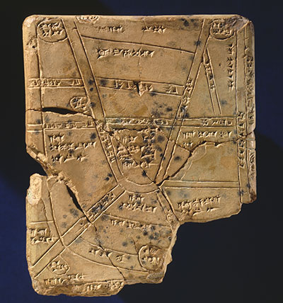
Surface water systems would have required some cooperation of local social groups to dig and maintain artificial canals. As the agricultural systems and the populations that depended on them grew, larger social groups based in cities organized irrigation on a larger scale, to the point that disputes in water allocation arose, textually documented in the 2nd millennium. Canal technology, originally aimed at irrigating fields, also began to serve transportation and drinking needs of the large Mesopotamian cities.
Beginning in the late 2nd millennium–early 1st millennium BCE, major water control works, including canals, dams, and drainage channels were built by the rulers of the empires of Assyria, Urartu, and their successors across Eurasia. A new technology, qanats, tapped into groundwater (see diagram to the left); it appears to have been particularly encouraged and facilitated by the Achaemenids (6th to 4th centuries BCE) on the Iranian Plateau.
Both over- and under-irrigation can reduce soil fertility through salinization which, combined with shifts in river courses, led to the abandonment of some settlements in Mesopotamia.

Naomi F. Miller, PH.D.,is a Consulting Scholar in the Penn Museum’s Near East Section.