 An expedition into the wilderness north of the Brooks Range in Alaska, where the nearest people are four days’ walk away and the closest supplies might as well be on the moon, naturally this does not happen by chance. Unanswered questions raised by other expeditions into the far north, clues to possible discoveries of significance, and in this case a vast region not explored by archaeologists, all led to studies and plans for work in the area, but the idea for this particular expedition had its background in several other trips that I had taken to Alaska’s Brooks Range.
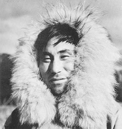
Ont the last, in the summer of 1962, my wife, Annie, and I excavated sites near the Eskimo village of Anaktuvuk Pass and in the next valley to the west, that of Chandler Lake. The remnants of a number of small nomadic bands of Nunamiut, or inland Eskimo had settled at Anaktuvuk in 1947 on the promise of a school for their children and the establishment of a trading post. Previous to this, their way of life was the least affected by Western culture of any of the aboriginal populations in Alaska. To be sure they had firearms, but hunting patterns had changed little. Ammunition had been obtained only by a journey to Bettles, nine days’ walk to the south. Only a few of the men had any knowledge of English. While we were there in 1962, the population increased from 102 to 105. In this group were five older men, including several who had worked with Stefansson during his early days in the Arctic.
The summer of 1962, we were interested in digging the more recent sites and comparing them with the present patterns in hopes of arguing back from the known in time to the unknown of archaeological sites. The old men often told us where sites would be found or would search with us. They would discuss the identification or use of an excavated tool and gave us much information that we could use later in interpreting our summer’s work. They pointed out one site on Chandler Lake as having been occupied by Indians, and we listened to their story of how the Indians had attempted to murder two of the Eskimo eating there with them. When excavated, this particular site fave some credence to their story. The structure was a circular wall of stones piled three feet high, most unlike any of the Eskimo dwellings, and the artifacts recovered lacked any appearance of being Eskimo.
The analysis of the 1962 excavations involved a considerable amount of research into Indian-Eskimo relationships, a subject that is poorly known, rarely documented and then with conflicting reports. The Nunamiut said that the Brooks Range to the east of Anaktuvuk Pass was a dark wilderness covered by Indians. Whereas the last Indians in the northern Brooks Range left there in the late 1800’s, Nunamiut children are still threatened with destruction by grizzly bears and Indians. The former are a real danger, but there hasn’t been an Indian on the north slope of the mountains for many years. The next major valley east of Anaktuvuk is the Itkilik, named from an Eskimo word meaning Indian. That valley formed an important Indian trade route between the south and the Arctic coast. It was also the easternmost extension of archaeological research in the Brooks Range up to 1966 and on many ethnographic maps is presented as the eastern boundary or Eskimo occupation in the mountains. There are sources, however, that indicate an Eskimo occupation throughout the mountains and suggest that this supposedly uninhabited area may have been as important as any other valley.
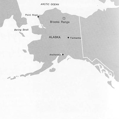
I wrote to one of the old men at Anaktuvuk Pass asking what he knew of the mountains east of the Itkilik, whether he had ever lived there, whether any other groups had lived there, whether there were well known routs through there, and so forth. The reply indicated that people had lived in some of the valleys to the east, but it lacked most of the details I had hoped for. However, his reply had a most unexpected bonus. My correspondent wrote that he had seen the remains of “pit houses” at Galbraith Lake, a large lake at the foot of the Atigun Valley, one valley east of Itkilik. This was indeed news, for pit houses in the mountains are rare and those excavated were in almost every case affiliated with the Ipiutak culture. The original Ipiutak site, excavated by Dr. Rainey in the 1940’s is located at Point Hope in westernmost Alaska, a good 450 air miles distant. The Ipiutak site was interpreted as a village of inland hunters who also exploited maritime resources, but only a few inland manifestations of this culture have ever been located. It was the hope of finding more such sites, spurred by the information from my Eskimo friend, that made me decide to go back to the Arctic.
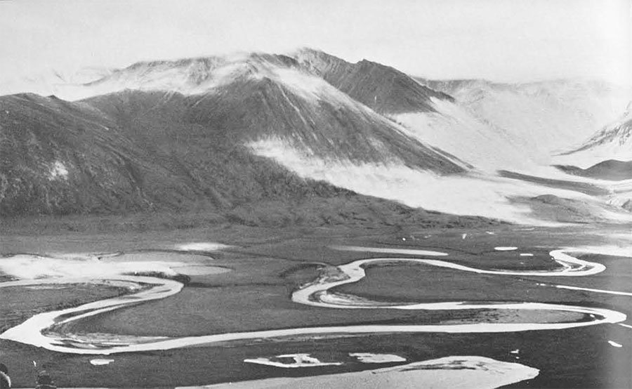
The correctness of this decision was quite evident after I had spent hours poring over the maps of the area to be searched. All indications were that the area had considerable archaeological potential. Immediately south of Galbraith Lake were a score of smaller lakes, each with the possibility of large willow patches as a fuel resource and the almost certainty of fish as one available food resource. The mountains all about the region held upland basins which are a favorite wintering ground for caribou. There were also broad passes from the east and west and at the Atigun’s headwaters. Surely there should be some evidence of men who would exploit the caribou. There was the additional, rather exciting possibility that we would find stratified deposits, for the mapp showed the Atigun as a wide meandering stream, a good indication of soft alluvial deposits. As expected, the Arctic Bibliography had no mention of the valley where we were to go. We would thus be working in a region where there was no record of exploration.
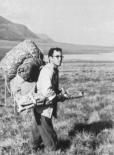
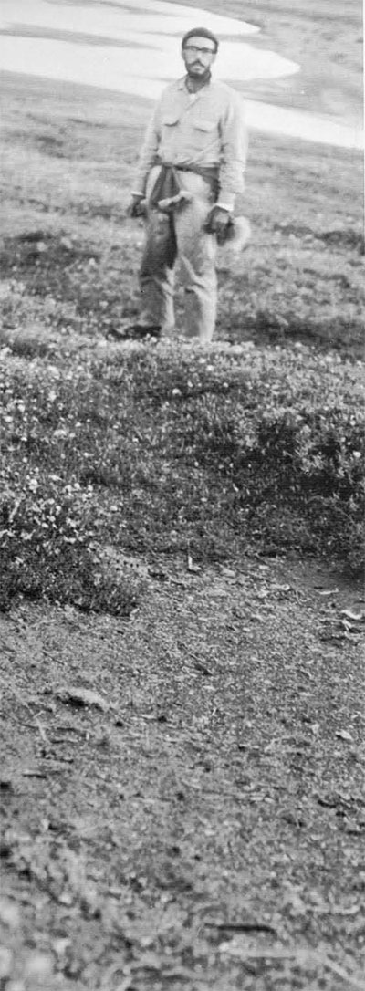
I decided that three weeks would give sufficient time to survey the valley for its archaeological potential. We would survey the foot of the Atigun Valley in the lakes region, an area twelve miles long and averaging three miles wide. Support was obtained from the University Museum and Sigma Xi. The field party, besides myself, would include my wife, and one of my Bryn Mawr students Victoria Grafstrom. I didn’t realize how isolated we would be. During this time we saw no other persons. We didn’t even hear an airplane. Since the survey would involve moving camp several times, we necessarily had to travel light and with a minimum of bulk. All of our equipment and food fit into a two-man rubber raft. Home was two pup tents, furnished only with sleeping bags and air mattresses. Housekeeping was no chore, but you should try cooking a meal for three cold, wet, hungry people while sitting in an area the size of a generous bath mat. Fortunately for our morale and the successful conduct of the survey there was only one such day’s confinement due to heavy rain. On the matter of weather we couldn’t have been more lucky. Of the twenty days in the field, sixteen were devoted exclusively to searching for sites, two days to moving camp, and one day we rested. The season was late enough for us to have a period of sub-freezing weather almost every day, but sufficiently early for the Arctic sun to disappear no more than a few hours of the day.
After several days in Fairbanks, spent purchasing food and the remainder of our equipment, we took a scheduled flight to Bettles where we were to meet our bush pilot, Paul Haggland, who would take us in a float plane the last few hours’ flight to the Atigun Valley. What follows are excerpts from my field journal with explanatory comments.
July 22: “Our flight path took us by Mt. Doonerak, just to the W. and the scenery there almost defies description. There are blue-green hanging lakes, waterfalls and pinnacles. Saw a lot of sheep. On reaching the divide we had to gain quite a bit of altitude in the Beaver in order to get over. We went into the Itkilik drainage, flew over the lake and cut E. to Galbraith.
 “Set up camp at the last large lake to the S. on the W. side of Atigun River. Cooked a late supper of soup and off to bed.” In what seemed no more than a few minutes the plane had departed leaving us on an unnamed lake in the eastern part of Alaska’s Brooks Range. We were on one of a number of small, close-set lakes nestled in the glacial scoured valley of the Atigun River. Our maps, compiled from aerial photos but never field checked, gave us only a hint of our new home. While the map was accurate in what it included, not shown were several large lakes and a number of streams. The biggest surprise came when we saw the Atigun River for the first time. It is shown on the map as a slow, shallow stream which is meanders north along the valley floor. It is in fact over 150 yards wide, swift and much too deep to wade. I had included a small rubber boat in our gear mainly for use in transporting gear when we moved camp. Without the boat our survey would have been restricted to only one side of the valley. Melt-water from a number of large, unnamed glaciers keeps the current swift and the water milky, in sharp contrast to the dark clear lake where we had set our first camp. Before leaving, the pilot was instructed to pick us up in three weeks at Galbraith Lake, ten miles, or nine hours’ walk to the north.
“July 23: Breakfast of bacon and eggs and straightened up camp. I found a tent ring on a knoll 100 yards S. of camp.” Even before our tents were set up we discovered we were not the first people to stay there. Our camp was set among the broken bones, cut willows and tent rings—circles of stones that once held down the edges of caribou-skin tents—of an Eskimo site. From historic data we knew that the last possible occupation of this valley was no later than 1920. In the early 1900’s the often spectacular caribou migration began to fail, either from the herd’s being reduced by disease or overhunting, or from a shift in the migration route. The caribou is the inland Eskimo’s major, sometimes exclusive, source of food and also provides the raw materials for clothing, shelter, and transportation. When caribou could no longer be found these hunters had to move. Most of them went to live with relatives or trading partners on the coast at Point Barrow, an area well supplied with marine mammals and hence not dependent on a single food resource. For fifteen or twenty years the Brooks Range sat silent.
Not all inland people found the adjustment to coastal living easy. Their skills used to hunt caribou were not the skills needed to capture walrus and seals or to harpoon a whale. They were treated as country bumpkins and with some reason. In the latter part of the 1930’s several Nunamiut bands returned to the areas they had previously hunted and found the caribou had returned. They went back to the familiar ways of nomadic hunting in the valleys of the Kilik, Chandler, and Anaktuvuk but the Atigun remained deserted and has to this day.
The pattern of camping on an old campsite was repeated. I suppose it should be expected since the number of areas for camping, or even sitting with a dry bottom, are severely limited by the terrain. A number of criteria should be met for a good camp. These include access to drinking water, a dry, flat area, and a supply of fuel. Finding water is never a problem where underlying permafrost causes water to stand everywhere. Fuel is another matter. The only fuel comes from small patches of stunted willow which burns like paper. Much to our regret we found that we often got warmer collecting wood than from sitting miserably around a meager, blowy, smoky bit of fire eager to consume wood, reluctant to give off heat.
Whenever we found a piece of dry ground large enough to support a tent, near a willow patch of even modest size, there would be a tent ring, or sometimes twenty tent rings. When we were out looking for sites and out stomachs said it was lunch time we had then to search for a place to sit, both dry and protected from the constant north wind. While I would light the Primus stove for tea, Annie or Vicky would distribute the cold caribou steaks waiting since breakfast. Long before the water reached a boil one or both of the girls would find artifacts while we sat. I once had to insist they stop digging and eat lunch, our stove in danger of overturning from two diggers intent only on looking for artifacts. Ten of our Atigun sites mark where we ate lunch. Our three camps mark the location of three more sites.

“July 24: Up at 7:30 when rain ended, sky overcast and little hope of clearing. We walked north to check out sand dunes, terraces and lakes. About mid-day I found a Denbigh point in a blowout…A white wolf howled in the morning. Spotted it through the glasses high on a ridge behind camp.” This was our first hint of important sites. While walking over a low sand knoll I spotted a thin red jasper point in a small area where the wind had cut the surface. Its size and the delicate workmanship of thin parallel flaking made it almost certainly related to the Denbigh Flint Culture. Further search turned up another similar point buried under a foot of sand. We noted the occurrence of fire-cracked rocks but thought nothing special of finding them. In time, however, a pattern emerged; all the sand sites later located had fire-cracked rocks and they were found nowhere else. That same day of work we had found indication of two occupations separated by several thousand years. The older site was possibly no more than a resting place but the recent one indicated a large camp with some length of occupation.
“July 27: We moved camp today.” After five days of surveying the country around Sheep Camp we could survey no farther in a day’s walking time so moving camp was the next order of business. We were fortunate in having a day when a north wind was strong enough to keep the mosquitoes down. But that was about our only good fortune. We ate a leisurely breakfast while waiting to see if the wet fog and overcast sky would clear and began packing once we knew the day would be somewhat dry. I discovered that ground squirrels had included part of our rubber raft in their past evening’s meal. Large scalloped pieces were taken out of the seam overlap and we didn’t know if the boat would hold air under the added pressure of a load. Ground squirrels are the goats of the Arctic—we later lost a pair of wool socks to their omnivorous appetites. Once loaded, the boat looked sound and for a test we pulled it along the lake shore to a point nearest the river. The lake has no outlet so we had to portage everything.
One misconception of the far north is that it is a cold bleak land perpetually locked in snow. A visit in the summer would dispel such an idea in an instant. Snow is only on the mountain tops and most of the country is covered with a lush green vegetation. Much of the vegetation grows in a soggy wet mass of cold soil. Endemic to this marshy tundra is the cottongrass. Its long thin blades are the green of the Arctic landscape and its whispy heads turn into fields of fluffy white cotton balls. But the vision of beauty soon becomes a harsh reality to contend with. The plant tends to grow in hummocks, some large enough to sit on and all large enough to trip anyone who must walk through them. I say “through” as the hummocks bend under the weight of a foot, or fall over, making it impossible to walk on top of them and thus avoid wet feet. We had a portage of only three-quarters of a mile from the lake to the river through this stuff but it took us five hours.
Our work had just begun as we still had to pull the boat along twelve miles of meandering river to our new camp. The same wind that protected us from the mosquitoes caught our high-piled gear like a sail. I remember this part of the day as a seemingly never-ending cycle of wading through shallow water on the bars of convex curves and walking along muddy banks above the deep water on the concave curves. Neither of the girls had hip boots, so I was alone on the bars. The boat was at the end of two hundred feet of line hitched so that it should pull toward the center of the river whenever the line was taut. The combination of contrary winds, currents, shallow water over immense bars of sand, caused some loss of temper. Several times I got to the end of a bar, and, unable to retreat, had to pull the boat to me, jump on, and trust that the current would push us on and the boat wouldn’t capsize. The few bits of rest on the trip came while hanging on, half in, half out of the boat waiting for it to touch shore.
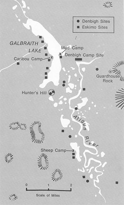
“July 28: Everyone exhausted by the time we got to Galbraith outlet but knowing we didn’t have far to go gave a bit of extra strength. A bit that was much needed at 1 A.M.” Camp was set up and we had supper. We ate in a valley painted rose by the sun hiding under the mountains, double enjoyed through the reflection in a mirror-still lake. The scenery is a compensation for almost anything. Mud Camp, as we called this place on account of the water, was on a tiny spot of not very level, dry ground, located on the peninsula bordering Galbraith’s outlet. The lake bottom there was shallow and the water too dirty to make easy drinking. We would usually scoop up a pailful and allow it to settle until the bottom was covered with a layer of fine grit before using. There was a sign of occupation there, a few cracked bones.
“July 29: It took an hour to walk back to camp through the worst mosquitoes possible. They were behind glasses, in the mouth and terribly loud…Back at the camp the wind picked up some and drove most away. At 11 P.M. some are still flying. 49 degrees.” No one has ever adequately described the physical and mental strain caused by these pests. The day after I wrote that, my nose felt as if it had been broken. While walking back to camp I was in such a hurry to get away from them that I didn’t stop to put on more repellent and a large number must have hit my defenses at their weakest point—where the glasses touch the bridge of the nose. It was several days before I could stand touching my nose. Their bite is normally insignificant. The real torture is their number and persistence. I doubt that Buddhism could make much headway in Arctic camps.
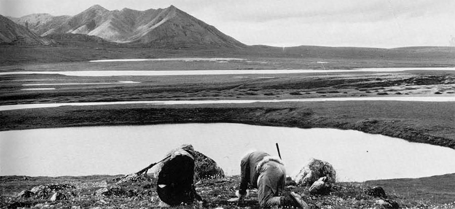
“July 31`: Warm day with a slight south wind and some mosquitoes, lots of cumulus clouds. After breakfast we began walking east, crossing the stream to view the Atigun where it loses considerable elevation in a short distance. On a still day we can hear the noise of rapids from camp. As we approach the junction of our stream [the Galbraith Lake outlet] with the Atigun we came onto an area of sand hills and blowouts and immediately began finding bones and flakes.”
The whole day was spent in this small area finding one artifact exposure after another over an area three-quarters of a mile long. We were on the north bank of the Atigun where it turns east, becomes constricted to a fourth of its previous size, and roars out of the valley. The north bank is a thick sand deposit extending back perhaps half a mile. The are must have been a favorite camping spot for an earlier culture. For hunting, it is a favored location. It is elevated, giving a good view of the surrounding country, essential for hunting caribou, as the trick is to spot them and put yourself in front of their path. The area is at the eastern entrance to the valley where game would certainly pass. It is also at the first place where game coming from the east would be able to ford the river. Any attempt at fording downstream would likely result in a good smashing in the rapids. Also, the major game trails from north to south on this side of the valley ran right through this particular sand-hill region.
In a few cases, we were able to uncover deposits that had not been excavated by the wind. We found a remarkable degree of preservation in these sites, with delicate fish bones and ribs of ground squirrels unchanged. The deposits we were able to check for size showed an oval deposit from eight to twelve feet long and several inches thick. The sites probably represent the debris that would build up on the floor of a dwelling after some weeks of occupation. There was no indication of how the dwellings may have looked or been constructed. The tent ring-stones so often found with recent Eskimo dwelling sites were absent. We did not find a single large stone at the site, but we did see everywhere the small fire-cracked rocks found earlier with the Denbigh points. We also found a few fragments of large, crude bifaces similar to ones found the next day at a Denbigh surface site, a chipping station located on a high bluff directly across the river. The only complete tool located in all the exposures at this site is a multibarbed antler projectile point, unlike any such artifact I have found described for the Arctic.
This site will receive the first attention when we return to the Atigun this summer. Although we found no direct evidence of one occupation superimposed over the another, there is every reason to believe that our planned excavations will reveal such. The deposits making up the site are composed of horizontally bedded sand and we noted differences in elevation between exposed layers of cultural debris no more than fifty feet apart. But as the job at hand was to find the extent of sites in the Atigun Valley we did not have the time needed to excavate yard after yard of sand. And at this point in our survey we knew that the region is archaeologically so important that we must return for a ful season’s excavations.
“August 5: Within 200 yds. of camp there are probably 40 or 50 tent rings. The area is a litter of bone scraps, cast off tin cans, parts of snowshoes, enamel pans, etc.” By this time we had moved camp for the third and last time, taking our gear directly across Galbraith Lake. We called this Caribou Camp to commemorate the fat bull that provided us with a supply of tasty meat. In contrast to Mud Camp, we were now on a narrow finger of fine gravel jutting well out into the lake. The water was clear and the ground flat. We had to remove artifacts from the ground before we could set up the tents. All of these lake sites gave the appearance of being the last occupation of the Atigun Valley. One of the snowshoes had been repaired with common flat-head nails. Here, however, we found our only association of artifacts with the remains of an extinct fauna. Directly on the surface was part of a mammoth tusk, cut square, and resting on top of a handful of pearly buttons and a glass bead.
The next week’s work showed that the west side of the lake was an almost continuous site, tent ring after tent ring and almost all of them with some evidence for the use of metal. We also found the “pit houses” which had first brought us to the Atigun country. On the first trip over in the boat when moving camp I almost fell into one while unloading gear. Our excavations in this pit and four others located nearby uncovered only recent artifacts, including a small brass oil lamp. The pits formed an eight-foot oval and were as much as three feet deep. While large enough for habitation, none had any indication of more than momentary occupation. From their unusually exposed location, on the north side of small lake-shore knolls, we deduce they were used as meat caches or blinds for hunting ducks. Had these “pit houses” which motivated our expedition been our only find, we would have been glum indeed.
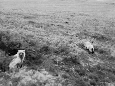
“August 9: We walked to the top of the hollow and getting there found ourselves 25 feet from a mother bear—still unaware of our presence.” My journal was wrong; she was at least forty feet away. We had made the mistake of trying for good photographs of a pair of grizzly bears without the use of a telephoto lens, actually several mistakes. What I assumed to be a pair of litter mates turned out to be a mother and her three-year old. On other occasions when I had seen grizzlys their first reaction had been to run away as fast as possible. But I had always been in areas hunted by the Nunamiut and had never come across a protective mother. When we saw what we were up against it was too late to retreat. The young one spotted us and ran behind its mother, she stood up, growling, and looking about. On spying us she dropped on all fours and started shuffling toward us, growling louder and with great ropes of saliva falling from her mouth. My crew of two certainly showed their bravery that day. With a bear coming after us Annie was all the while shooting pictures with the still camera and Vicky was taking movies. I had my rifle aimed and ready to fire if there were nothing else possible. The Eskimos once told us that if a bear charges we should build a fire or yell. I wasn’t going to start fumbling in my pockets for a light, so we tried next best. Our yelling stopped her about fifteen feet from us and she turned slowly and began walking away.
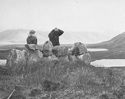
We had encountered the bears on our return from a productive day’s work. That day had been spent searching a large hill which commands the center of Atigun Valley just south of Galbraith Lake. Its location and height made it almost certain that hunters would have used it for a lookout for game. We called it Hunter’s Hill even before we had our proof. A peculiar bump, spotted days before through our binoculars, turned out to be a low wall of boulders. Such structures were used by the Eskimo as windbreaks and also to break their silhouette against the skyline. A second, though smaller, structure was found not many yards down the north slope of Hunter’s Hill. Both appear to be recent from the artifacts found scattered about. At three other points on the hilltop, however, we located chipping stations of some antiquity. One of these had a well-made microblade that might belong to the Denbigh or an earlier culture. The remainder of the hilltop artifacts were the ubiquitous flakes of flint and chert, a few of them showing signs of use. Two other stone structures were located on the slopes, both rock cairns used as meat caches. One cairn, lined with thin flat slabs could have served also as a deadfall trap for small game.
“August 12: We were up a hundred times during the night in anticipation of the plane’s coming for us today. Finished the last of the coffee, my last cigarette, and all of our food. We have only caribou left to eat and tea to drink. Have already heard the airplane every few minutes and it is only 9:30 A.M. The plane arrived at 11:30.”
While the original impetus for taking us to the Atigun Valley, a promise of an Ipiutak site, had not proven out, the three weeks’ work was far from a failure. We had located over forty archaeological sites, five of which are sizable villages of modern Eskimo occupation. At least at that time the Atigun Valley had a population equal to that of other Brooks Range valleys. Some of the tent-ring sites gave no indication of age and could belong to earlier periods, as this particular trait goes back five thousand years or more in Alaskan prehistory. From the recent to Denbigh there is considerable hiatus in the archaeological remains. It is the discovery of the Denbigh material that made the trip eminently successful. We had extended the range of this culture considerably to the east and had found the first Denbigh sites containing rich organic remains. These sites may also prove to be stratified, an almost unique situation for Brooks Range archaeology. If so, they will be of great value in interpreting the numerous surface finds that have characterized other areas in the Brooks Range.
On the east side of Galbraith Lake we found a surface site which may be somewhat earlier than Denbigh. We were lucky to find it. The artifacts were so altered by weathering and covered with lichens they were almost indistinguishable from the glacial gravels. In contrast, Denbigh artifacts of identical types of chert appear as fresh as if fabricated but one fourth of them have signs of edge use and a few were deliberately shaped into scrapers or gravers. Similar collections from northwest Canada and western Alaska definitely predate Denbigh and may be the oldest in the Arctic.

We have already begun planning for a return trip to the Atigun this summer. As previously mentioned, the primary purpose will be excavation of the Denbigh sites in the sand-hill region. We will continue the survey of the Atigun and expect to extend that operation quite a distance to the east. The three weeks in 1966 were insufficient for checking all the likely spots. First on our survey schedule will be the exploration of a series of caves pocketing Guardhouse Rock, a high mountain spur having the appearance of a guard tower punctuated with windows looking in all directions. At its base is the largest of the Denbigh chipping stations and the sand-hill sites are just across the river. The caves, we hope, attracted hunters; we shall not know until next summer, for as always one expedition leads to another.