In 1926 Hocart wrote that “what is needed for Ceylon archaeology is a stratified site” (A.M. Hocart in Archaeological Survey of Ceylon, Annual Report, 1926:15); today, some forty years later, this statement still applies. Several factors have been detrimental to the growth of this aspect of archaeological research. The island of Ceylon has been considered an extension of the Indian mainland. Thus, the focus of archaeological interest amongst non-Ceylonese archaeologists has tended to be more on the mainland than on the isle. In Ceylon itself the Archaeological Survey with its limited resources and personnel has concentrated upon the study and interpretation of textual materials, decipherment of inscriptions, and restoration of monuments of national and religious importance. Specialized research involving stratified excavation and interpretation of archaeological evidence is still in its initial stages. Consequently, our knowledge of pre- and proto-historic Ceylon is extremely meager; and the picture that emerges of even the early historical period is unbalanced since it is based upon textual and epigraphical evidence only. The early history of Ceylon is largely based upon the testimony of the Mahavamsa text, which, although a useful document on later times, tends toward the legendary when dealing with the earliest period. Even at its best it is limited in its coverage of different facets of history. Thus one does not even begin to understand the development and growth of human society in Ceylon in its totality.
In an attempt to bridge some of the gap between the late Stone Age and the beginning of documented history, we undertook a preliminary archaeological exploration in Ceylon in February and March of 1967. One of our objective3s was to locate a proto-historic settlement site, the excavation of which would help establish relative culture sequences of the island. The project was sponsored by the University Museum. Its completion was possible through the help and excellent co-operation of the people and Government of Ceylon. We are greatly indebted to Dr. G.D. Godakumbura and the staff of the Department of Archaeology for their help, especially Dr. Saddhamangala Karunaratne who accompanied us on the exploration, often under very trying conditions. We also acknowledge with gratitude the help of Mr. M. J. Perera of the Ministry of Education and the Government Agents of Jaffna, Mannar and Anuradhapura districts, who provided many facilities including transport; and the encouragement and assistance of the American Embassy in Colombo.
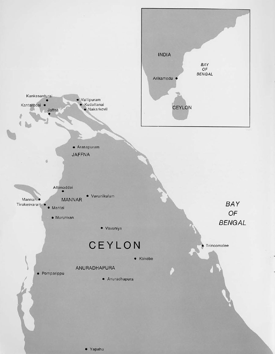
As no absolute dates nor culture sequences in the archaeology of Ceylon have ever been defined, we began our exploration by searching for evidence of foreign contacts which would —because of association—eventually provide fixed points for the dating of early Ceylon cultures. Therefore the focus of our survey this year was primarily on the northern “dry zone,” i.e., the Jaffna, Mannar and Anuradhapura districts in which early contact was probably maintained with the Indian mainland.
In carrying out the survey, two practical problems were encountered. First, in Ceylon, except for ruins of Buddhist dagobas (Buddhist relic-mounds) or other large structural monuments, the contours of settlement mounds could not be easily distinguished, making exploration work rather slow and difficult. As a result of their abandonment in historical times the deserted settlement sites were covered with scrub and jungle growth because even in the so-called “dry zone” the annual rainfall averages between sixty and one hundred inches. The dense jungle growth disguises the otherwise easily detectable surface indications of settlements or contours of low mounds. In some areas agricultural development and rehabilitation programs have uncovered some of the buried remains of earlier settlements. But unfortunately much of the evidence which is of no intrinsic material value in the eyes of the villagers is being either destroyed or reburied. This situation could perhaps be corrected if local people were made aware of the importance of this material. The second practical problem encountered in the survey was that of identifying and interpreting the surface pottery finds, for which there are at present no available stratified or typological sequences.
Mantai and Vicinity
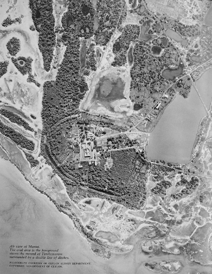
One of our first main points of investigation was the already known site of Tirukesvaram (or Mantai) situated on the western coast of Ceylon across from Mannar. The mound proper rises to a maximum height of about twenty feet above sea level. Parts of it are covered with scrub jungle growth while the rest is the site of the famous Tirukesvaram temple. The site is located in the Palk strait, on the route of ancient overseas trade from the Mediterranean to the east, and in close proximity to the southeastern coast of India. According to tradition and historical evidence this was a great port town in ancient times, and it consequently has attracted the attention of several scholars over the years. As early as 1887 some pits were dug by Boake (see W.J. S. Boake: “Tirukketisvaram, Mahatirtha, Matoddam, or Mantoddai,” J. Royal Asiatic Society, Ceylon Branch, 1887-88: 107-114). Between 1925 and 1928 excavations were conducted by Hocart (Hocart: op.cit.: 15), and in 1950-51 by Sanmuganathan (S. Sanmuganathan: in Archaeological Survey of Ceylon, Annual Report, 1950: 15, and 1951:33). But except for these references no published detail accounts of these excavations came to our notice. The field records of Sanmuganathan’s investigations could not be located but the brief notices record his excavating two ‘ancient’ roads, a pottery rimmed soakage pit and two stone-lined wells. A collection of potsherds in the Anuradhapura museum, said to be from his excavations, as well as the surface collection made by us date the antiquity of the site to the beginning of the Christian era. The pottery included such varied and clearly recognizable types as Roman red ware, Arikamedu-type rouletted ware, Chinese celadon and Persian glazed wares of medieval times, indicating a long occupation. This is also confirmed by the number of levels to be seen in the exposed cross-sections from the time of Sanmuganathan’s excavations.
Air-Survey photographs as well as investigations at the site reveal the existence of moats, but their correlation to a particular phase of the occupation can be determined only by future archaeological work.
Traces of buried settlements were observed over an area of several miles inland from Mantai. Between the coast and Anuradhapura are Tamrakulam, Maligathidal, Vedayamurripu, Amaimottai, Pappamottai, Chegapadapiddy, and Minukkan. Some pottery types at these sites showed similarities to those from Tirukesvaram. It is likely that the peripheral area of occupation extended far beyond the Tirukesvaram mound itself. In the Mantai village are wells dug under redevelopment schemes; the cross-section of one of these shows habitational debris up to a depth of some ten to twelve feet consisting of potsherds, stone, and brick from structures. The evaluation of this evidence in its historical and chronological context must await the establishment of the chronology and definition of Tirukesvaram cultures.
Kantarodai and Jaffna Peninsula
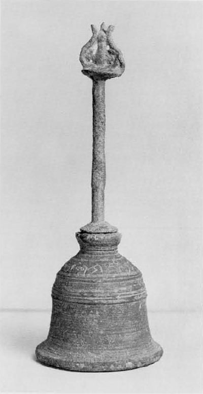
Next, we focused our attention on the Jaffna peninsula, which would have been a likely point of contact with India and where, according to tradition, Sanghamitra had landed with a branch of the Bodhi tree in the third century B.C. We started our investigations with the village of Kantarodai, which lies inland between Jaffna and Kankesanturai. Kantarodai consists of two distinct areas: the village proper and an adjoining palmyra grove. A series of mounds in the grove was observed by Pieris in 1917 and identified as a Buddhist complex consisting of several dagobas (P.E. Pieris: “Nagadipa and Buddhist Remains in Jaffna,” J. Royal Asiatic Society, Ceylon Branch, XXVI, 1917: 11-30, and XXVIII, 1919: 40-67). Small-scale excavations conducted by him revealed the use of “glazed tiles” and limestone, which incidentally is not local to that region. Pieris also records that he collected “punch-marked” and “Roman” coins which the village boys had picked up in that general area. This still remains a favorite pastime of children on their way to and from school. The Ceylon Department of Archaeology is currently conducting an excavation within the palmyra grove area at Kantarodai and to the east of the earlier trenches. This excavation has so far brought to light the bases and architectural fragments of several small dagobas. In addition, the trenches have yielded coins of the “punch-marked,” “Roman,” and Lakshmi plaque types. If their stratigraphic position in relation to the structural phases can be determined, they will prove to be of great importance in dating the monuments. Thus, detailed reports on the excavation are keenly awaited.
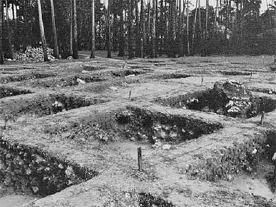


Our exploration in the general area indicated that the habitation site was a few furlongs north of the dagoba site, that is, in the same area as the present village settlement of Kantarodai. On the surface, in the debris accumulated from making village lanes and in a recently dug soakage-tank pit were found substantial quantities of potsherds which parallel the Iron Age and early historical wares of South India, i.e., the so-called “Megalithic” black-and-red ware and the rouletted ware of the Arikamedu type and its many variants (cf. R. E. M. Wheeler: “Arikamedu: An Indo-Roman Trading-station on the East Coast of India,” Ancient India, 2, 1946: 17-124). Excavation in a small trial trench confirmed that the top levels were coeval with the Arikamedu early historical period. It was not possible to excavate even one pit down to virgin soil but the little stratified evidence we could obtain from the upper levels confirmed that they were of the first and second centuries A.D. IT is probable that there were earlier settlements since the soakage-tank had revealed habitation debris of over twelve feet, and surface finds consisted of material similar to that which has been found in stratified contexts of an earlier date on the Indian mainland. It was also evident that we were in the midst of the habitation area; this, therefore, would be one of the most logical places for future excavation. Having located a settlement in close proximity to a religious structural complex, we can hope that eventually, after a season or two of excavation, it will be possible to correlate an early Buddhist complex to a habitation area.
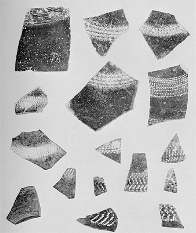
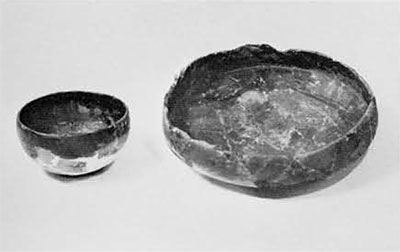
The bulk of our finds at Kantarodai consists of pottery which was found in a substantial quantity; other finds include iron slag, coral pieces, and a fragmentary Lakshmi plaque, all in association with rouletted ware. The pottery can broadly be considered of three classes:
Type A is a very distinctive ware though limited in quantity compared to the bulk of the remaining sherds. It is identical with the rouletted ware and its variants from Arikamedu (cf. R. E. M. Wheeler, op. cit.) and was in all likelihood imported from the Indian coast. One rim sherd of a Roman red-ware cup was also found.
Type B parallels the “Megalithic” black-and-red ware of South India where it is found extensively in association with the Iron Age material, a few sherds also being found at Arikamedu.
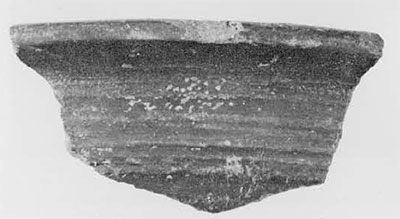
Type C forms the bulk of the pottery and was most probably of local manufacture. It is a thick ware, used for larger jars and cooking vessels. It is slipped or plain and ranges in color from dull red to purplish brown and black; the rim, neck, and upper part of the body are wheel-turned while the lower part is shaped by beating the clay from the neck down, producing quite a range in the thickness of the pot. The lower part of the body usually has uneven designs which were most probably produced by beating and thinning of the walls with a corrugated paddle
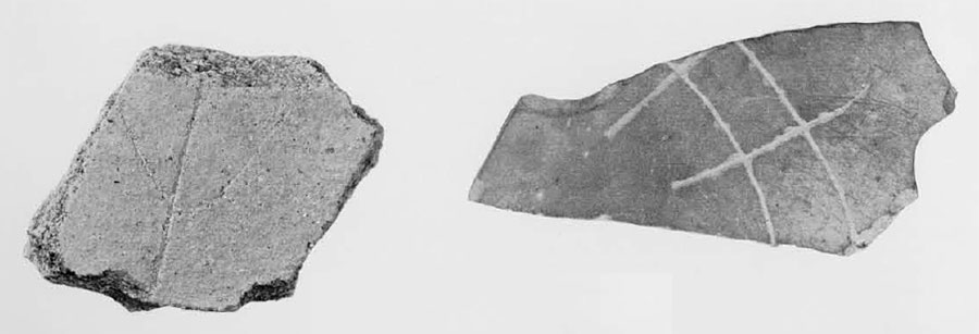
Outside of these three main types there were some dishes in unslipped red or black wares and one small sherd of a plain grey ware with two concentric incised lines; a complete classification of these has not yet been made.
The dates of Arikamedu are fairly securely established, covering the first few centuries of the Christian era (Wheeler, op. cit.), and consequently, we can ascertain the date of at least one cultural phase at Kantarodai which is our only fixed point of dating in Ceylon’s early historical archaeology. A further narrowing down of the dates should be possible after substantial excavations. A few sherds of our Type A were also found at the Buddhist site of Kantarodai and thus may subsequently prove to be of great value for correlating the two sites. Also, pointing to contact between Kantarodai and Anuradhapura are a couple of sherds of both Types A and B (now in the Anuradhapura museum) from the Gedige site in Anuradhapura itself.
We explored for settlements in several directions from Kantarodai. On the west, following the water inlet from Kantarodai to the sea, we observed a series of small mounds at Ammankovil; we noticed ruins of a small brick structure and pottery sherds scattered on the mounds and in the adjoining fields, but they seemed to be of rather recent date. In the easter part of the peninsula, that is, in the sandy stretch lying between the lagoon and the sea—about half a mile from the fishing village of Nakarkobil, and at Kudattanai—we again observed potsherds scattered over rather extensive areas but with no other signs of habitation. There were no means of identifying them with any known ceramic type of antiquity. The collection consisted entirely of a sturdy red ware; the rim sherds indicated that they were mostly water jars and cooking vessels, some of which may date from fairly recent occupation. Farther north is Vallipuram, the site of a a modern Vishnu temple and also reported to be the findspot of a gold-plate inscription of historical times. The temple stands on a mound and in the exposed sections along the outer fringes of this mound traces of brick structures, of unknown date, can be seen. Near the temple, large quantities of potsherds and some glass beads were collected but proved to be of unrecognizable date of origin.
Structural Sites in Manner and the Jaffna Districts
One other line of research leads to the hypothesis that there was a considerable number of settlements in the northern regions in earlier times and perhaps connected with the Anuradhapura phase of Ceylon history. In the now almost deserted interior regions of the Mannar and Jaffna districts it was possible to locate—with the help of local villagers—several low mounds, sometimes only a few feet above the surrounding surface level. Architectural members and stone sculptures projected from the surface of these mounds. Occasionally scattered pottery sherds were also visible. Since the significance of this material is unknown due to lack of stratified or stylistic sequences, stratified excavations at some of these mounds would certainly be advisable. If action is taken at an early date, it may be possible to salvage enough material for studying settlement patterns, for in spite of the jungle growth and the inaccessibility of some of these mounds, they are considered by the villagers as dagoba sites with hidden treasures and are constantly being robbed by treasure hunters as well as by brick and stone lifters. We came across several where the debris left by the treasure hunters included beer bottles and ladders for going down in the pits, indicating rather recent intrusion. One such spot was at Arasapuram. A few miles off the main road connecting Jaffna and Mannar, and now under thick jungle cover is a low mound, most probably formed by the debris of a structure. Contours of the mound could be distinguished once we were at the spot, but not from any distance through the jungle. Bricks were scattered over the surface and a deep pit (from which bricks had been removed) could be seen.
Several such sites were pointed out to us by villagers in the Mannar district. Some of these are mentioned below; when plotted on a map they indicate the distribution of settlements between the coast and Anuradhapura, which was the center of civilization in the early phase of Ceylon history.
Kollanmaruthumadu (off the Mannar-Vavunia road): ruins of two structures (dagobas?) showing the use of different size bricks, perhaps representing two phases of construction, exposed by treasure hunters
Vilathikulam (in the same area as above): bricks and pieces of pottery brought to the surface by road construction.
Rasamaddu (in Nanattan west): ruins of a brick structure forming a low mound.
Katkadanthakulam (south of the Giant Tank): ruins of a structure and traces of images.
Maliapitti: ruins of dagoba (?) being used extensively as a quarry for the supply of bricks to the village.
Vavunikulam: in front of the Saivite temple, debris from an extensive structure which had been completely leveled for laying the foundations of a new building.
Attimoddai: in the deserted jungle area, about two miles from the village, pottery sherds, stone pillar bases, and a fragmentary stone sculpture sticking out of the ground indicate an extensive abandoned settlement.
Burial Sites
We also visited several urn and cist burial sites. They assume a great importance in the archaeology of Ceylon because they show features analogous to those of South India. On the mainland they antedate in origin the period of Roman contact and were associated with the Iron Age culture of the second half of the first millennium B.C.
In Ceylon, the most important published site of urn-burials is Pomparippu (Archaeological Survey of Ceylon, Annual Report, 1957: 12-16). In the process of a road construction through the Wilpattu Wild Life Sanctuary, at a distance of about two miles from Pomparippu, some urn-burials were brought to light which were subsequently excavated by the Archaeological Survey of Ceylon. These burials typologically and in details of ritual such as the depositing of iron objects and pottery in the graves are akin to those form South India. More specific parallels can be noticed between certain shapes and the inverted technique of pottery firing itself. However, the Pomparippu pottery is cruder than the Indian but since the Indian complex certainly represents several phases, it would be necessary to compare in detail the Pomparippu material with that from Indian sites in order to narrow down the dates and area of immediate contact.
At a cist burial site at Gulsohankanatte (about a mile from Yapahu) Dr. Raja de Silva excavated two burials containing iron objects and pottery similar to the South Indian wares.
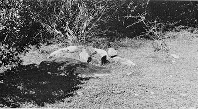
At Kokebe (off the Anunadhapura-Trincomalee road, about a mile from the village of Konwewa) is another cist burial site of considerable interest; it covers an area of over two acres, now overgrown with jungle vegetation. Some of the stone slabs projecting from the ground clearly demarcate the outlines of cists. Several small irregular shaped stones (perhaps serving as capstones) were observed on the surface in the center of the area outlined by the stone slabs. Stone is easily available from natural outcrops in the vicinity. The site is more or less undisturbed, except along the road which cuts through it. In the construction of this road, villagers claim to have found pottery, cones, and ashes, but destroyed or reburied them because of their funerary nature. The burial site is to the southwest of an early Buddhist settlement using partly natural rock outcrops and partly supplemental brick structural members. The earliest Brahmi inscription from the Buddhist site dates from about the second century B.C. No chronological connection between the Buddhist and the burial site is known, but if the burial site is actually a cist burial site of the South Indian order, then the two can not be far removed in time and the burials could either antedate or be contemporaneous with the earliest phase of the Buddhist settlement. Stone arrangements, similar to Kokebe, and previously recorded as “dolmens” can also be seen, scattered through a paddy field at Gurugal Hinna about thirty-one miles from Anuradhapura along the road to Trincomalee.
In retrospect, as we evaluate the significance and limitations of our work this season, we realize that we are nowhere near defining the proto-historic cultures of Ceylon. However, we now have a better idea of the distribution of settlements in a few districts of northern Ceylon, and we also have one fairly secure dating point at Kantarodai providing us with a base for determining a relative chronological sequence. Nowhere in our limited investigations did we locate of identify any material culture antedating the closing centuries of the first millennium B.C., so the earlier history of the island is still more obscure.
It should be stressed once again that a matter of prime importance in the archaeology of Ceylon is to obtain a series of culture sequences from stratified excavations. One crucial site for the historical archaeology of the island is Tirukesvaram. A series of trenches should be excavated so as to clarify the occupation phases of the site, and the expansion of the settlement in the peripheral area, and to determine the extent of trade and external contacts and their effect on the economy of the island. Another line of investigation should focus on stratified excavation of a cist burial at Kokebe for the purpose of revealing its plan and establishing its association with a cultural phase. Finally, because of the fixed dating point from the habitation area of Kantarodai, we believe that this site has the most potential for our future excavation. Only by proceeding from the dateable in a reverse chronological order will we be able to study and define more clearly the different phases of the proto-historic period and ultimately bridge the gap between prehistory and the historical period in Ceylon.