Trade and Maritime Space
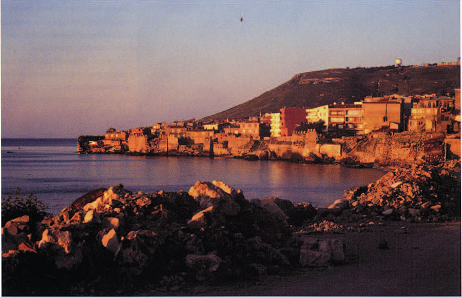
The study of ancient trade has greatly enhanced our understanding of the development of civilizations. In some cases long-distance trade has been proposed as the critical element in fostering the emergence of early states and other polities. For the most part, trade has been investigated within the Limits of the territory of a culture. Trade routes across water provide unique opportunities to study cultural interaction beyond national boundaries and between ancient regions. Integrating studies of land and sea routes has not been achieved due to the differences in methods and procedures. Our project attempts to link the study of coastal land sites and the maritime trade routes or “maritime space” in a single research design (Fig. 1).
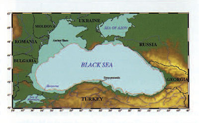
The Black Sea has long been important in linking the economies of Europe, Eurasia, and the Middle East (Fig. 2). Tantalizing suggestions of its early role as a hub of maritime activity come from archaeological objects in old museum collections. One example is the Bronze Age “Borodino Treasure,” found on the Moldavian coast of the Black Sea (Fig. 3). The jade axes and decorated spearpoints in the assemblage were made far to the east, in the Sayan Mountains of southern Siberia (Shishlina i987), but the closest parallels to these objects are axes found in one of the Bronze Age hoards (treasure L) known as “Pram’s Treasure” from Troy at the Dardenelles just at the entrance of the Black Sea (Treister 1996). These finds seem to indicate that the Black Sea already functioned as a crossroads of the ancient world by the beginning of the 2nd millennium BC. Another, later example is seen in the gold objects that the Greeks traded with Scythians who lived on the north coast of the Black Sea (Fig. 4). Such trade goods are commonly found in the network of Greek colonies that connected the classical world with that of the Eurasian steppe on the north coast.
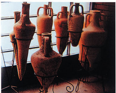
Further evidence that ancient trade across the Black Sea was extensive and intense comes from Russian excavations of Hellenistic settlements on the north coast of the Black Sea. Some 15,000 examples of amphorae (storage vessels) stamped with the name of the producing city, “Sinop” (Fig. 5), have been found in these settlements, suggesting that some product was being exported in bulk from Sinop on the south coast directly across the Black Sea (Fedoseev 1993).
Unlike land trade, maritime trade allows economically and politically heterogeneous societies to interact directly even if they are not contiguous. We can trace the development of the Black Sea’s role in trade by documenting the distinctive nature of its coastal culture. We employ a geographical model defining the relationship of the coastal sites (ports) with the surrounding lands (hinterland) and their economic partners overseas (foreland) (Whitcomb and Johnson 1982). In addition, we consider the “maritime space” comprising the traders, their boats, and the trade routes that linked the ports with the forelands (Weigland 1958); typically, this space is all but invisible archaeologically. By integrating land and underwater archaeology we can track the trade routes and the commodities that were exchanged from known points. This model creates a unified research framework by providing comparable data from inland, coastal, and underwater archaeological contexts.
The Creation of the Black Sea

Museum Object Number(s): 30-33-2A / 30-33-1.2 / 30-33-1.4 / 30-33-1.7 / 30-33-1.9
Black Sea has only recently (by geological standards) achieved its modern shape and extent. During the last glacial period, the Black Sea became separated from the world’s oceans when dropping sea levels caused its connection with the Mediterranean Sea near modern Istanbul to drain completely (see Fig. 2). Fed only by the freshwater rivers of the steppe, the Black Sea became the largest lake in the world. Like all Eurasia at that time, the Black Sea coast was characterized by Pleistocene environments of steppe and forest lands (such as are now seen far to the north), and was roamed by large animals that are now extinct. A huge coastal plain was exposed by the lowered level of the water.
As the last glacial period came to an end around 10,000 years ago, glaciers began to recede and world sea levels began rising, approaching their modern positions. As geologists William Ryan and Walter Pitman from Columbia University reconstruct the geological history of the region, the Mediterranean and the Aegean rose with the rest of the world’s oceans, but the Black Sea maintained its lower level, still being fed only with fresh water (Ryan et al. 1997). According to their reconstruction, at a point some 7600 years ago the thin rim of a natural dam which separated the Mediterranean from the Black Sea basin broke through and salt water poured rapidly into the Black Sea (Ryan and Pitman 1998). The resulting inundation of the shoreline certainly would have had an impact upon the coastal populations. Just as significant was the transformation of the whole region as the natural environment took on its modern character. The major post-Pleistocene changes were the shift from a freshwater coastal ecology to a marine one, and the northward migration of steppe and forest zones. Such ecological changes would have radically affected conditions for foragers, hunters and fishers, and early herders and farmers.
Sinop Peninsula
The Sinop peninsula, a small (20 by 20 km) plain sloping gently into the Black Sea, provides an ideal setting for exploring the economic documented an intensive and extensive occupation of the peninsula from the late Paleolithic through the Ottoman periods (Doonan. Cantos. and Hiebert n.d.).
In collaboration with the institute for Exploration in Mystic, Connecticut, our work has been extended out into the water itself, resulting in a combined survey of potential trade routes from hinterland to port to the maritime space. The institute’s use of robotics—as opposed to divers—frees underwater investigations from the typical opportunistic strategy of finding ships. and permits systematic investigation of the underwater environment through extended searching in both shallow and deep water (Ballard 1993). For the first time, we can actually document the pattern of trade along the trade route itself. While land and underwater survey reveals the pattern of land use, only excavation can reveal the specific characteristics of the domestic economy, including seasonal use of land. animals, and plants. Preliminary excavations at the Sinop citadel provided a glimpse of the economic structure of a specific port site. The geomorphology of the coastal region reveals the dynamic coastline and ecology which correlate with historically documented economic specialization.
Ecological and Topographic Zones
The Pantie Mountains form a cliff-like edge along the southern Black Sea coast, isolating the mostly inhospitable and rugged coastal plain from central Anatolia. Only in a few places, such as the Sinop peninsula, does the coastal plain broaden. In our archaeological survey, we work within several ecological and topographic zones.
Highlands

The highlands of the Sinop peninsula lead up through the Pontic Mountains to the Anatolian plateau. This highland landscape is dramatically eroded, forming steep-sided valleys dropping towards the sea. The steep slopes, unsuitability of most soils for agriculture, and deep snows in winter combine to make this area sparsely populated, though the treeless ridge tops served as rugged but clear paths of communication. Most modern roads today are cut into the slopes of the rocky ridges. The highlands offer a wide diversity of natural resources that were used in the past (Fig. 6). Wood and mineral resources, seasonally available pastures, and collectable resources such as hazelnuts enticed coastal populations into the highlands. The tradi tional and archaeologically observed pattern is of a very strong seasonal shift between highland and coastal occupation on the Sinop peninsula. Evidence of occupation in the Sinop peninsula highlands is comparable in date with the occupation along the coast, and in many cases, must represent the same populations at different times of the year.
Coastal Regions
The northern coastal region of the Sinop peninsula is comprised of the broad fertile valley of the Karasu. This region includes the most extensive and stable agricultural land in the survey area. The ancient harbor at Hamsilos near the mouth of the Karasu River silted up in modern times as a result of deforestation and agricultural activities in the valley.
The northwest corner of the Sinop peninsula rests on basalt bedrock, which protects it from the constant erosion experienced by the rest of the Turkish coast. The basalt at Ince Burun also preserves the earliest remains of human activity on the coast. The coastal scarp forms a shelf that has caught lithic materials washed from eroding layers above which date to as early as 15,000-7000 years ago—evidence of occupation around the Black Sea prior to its flooding.
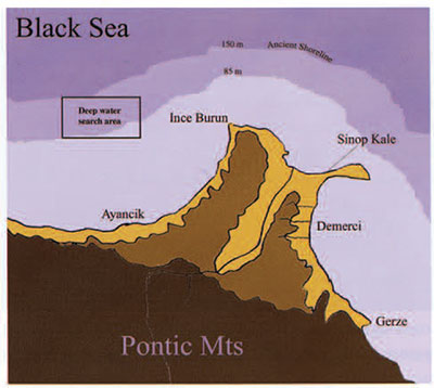
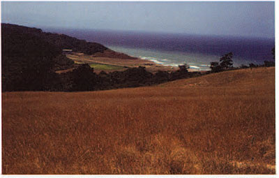
The forests of Ince Burun were renowned for their sturdy oaks, which were used to build the Ottoman fleet in the 15th century. South of Ince Brun, along the west coast of the Sinop peninsula, short narrow valleys cut through the Pontic landscape of the Black Sea coastal areas (Hiebert 1997). Bounded by the Pontic Mountains to the south and by the Black Sea on three sides. the Sinop peninsula presents a geographically circumscribed region of rich agricultural lands that includes a significant number of archaeological sites (Fig. 7). Its geographic diversity encapsulates in small the entire Black Sea coastal area and its characteristic features. Five years of intensive field walking on the peninsula has Mountains, which descend dramatically into the sea in many places. Some of the west coast valleys open onto small gem-like bays, such as at Saraycik (Fig. 8), but most of the coast drops straight to the water in steep cliffs. Forest resources along this coast have traditionally been used for ship building. Within living memory. sails for local sailboats were made in the town of Ayancik.

Along the east coast of the peninsula, small rivers form a series of broad valleys that connect the highlands to the coast. This area has the best agricultural land and the longest record of occupation on the Sinop peninsula. The area of good farmland was considerably larger in the past, but has been constantly altered by coastal erosion. Several standing Byzantine and Roman period buildings are currently eroding into the sea. Demirci is the site of a large Hellenistic and Roman settlement, where remains of an amphora “factory” are being excavated (KassabTezgör and Tatlican 1997). To the south, the coast near Gerze is rugged, with foothills running down into the sea. A number of fertile valleys are tucked within these hills, but they are heavily forested and difficult to survey.
Sinop town is located on the northeast corner of the Sinop peninsula at Box tepee, a steep-sided limestone headland attached to the mainland by a narrow low-lying sandy isthmus. Soils on the point are thin and do not support extensive agriculture, but the town is renowned for its twin harbors (see Fig. I). The inner harbor is preferred for large boats, while it is easiest for small boats to be pulled up in the outer harbor (see cover). Bronze Age remains found at the Sinop Kale (fort) indicate that the site was occupied possibly as early as the late 3rd millennium BC. The main town, surrounded by a massive stone wall, has occupied the isthmus since the 4th century BC. The modern town overlies the ancient town, and it is almost impossible to find a place for excavation.
The Underwater Landscape
Systematic underwater survey is a natural extension of the survey on land, allowing us to investigate the maritime space of this economic system and completing our goal of survey “from mountaintop to ocean bottom” (Hiebert et al. 1997). Both the inner and outer harbor areas at Sinop have flat sandy floors, and have been extensively dragged with large bottom-fishing nets. This has effectively destroyed features on the flat sea floor, including shipwrecks. Several wrecks are known to lie in shallow water among the rocks off the Sinop coast, where net fishing is knot carried out (Kassab-Tezgör 1998).
The shortest route across the Black Sea lies almost due north, from Sinop to the Crimea, To the east, trade routes would have connected Sinop with the eastern regions of the Black Sea: to areas rich in metal ore and timber, and to traditional trading paths for peoples from the Caucasus region and the steppe. West from Sinop, the trade routes would have led to the Bosporus and the maritime outlet to the Aegean and Mediterranean seas, as well as to the rich Balkan coast of the Black Sea. Fishermen we interviewed indicated that they did not fish beyond 85 meters, since that is approximately the depth at which their nets become discolored by the stagnant, anoxic water of the deeper Black Sea. The deep layer of oxygen-free water is denser than the surface water; the two distinct layers do not mix freely, creating a unique environment where microbes and woodhorers do not destroy organic materials such as wooden ships. Thus, investigations at depths greater than 75 meters should provide us with the opportunity to search for traces of our hypothesized trade routes.
To the east of Sinop, we found that the bottom slopes gently to a former coastline, today under 150 meters of water (Ballard, Coleman. and Rosenberg n.d.). The topography of the submerged landscape echoes the rolling landscape of the modern coastal valleys. Of particular importance, the lack of large modern rivers near Sinop results in a very low rate of sedimentation on the sea floor; there have been only centimeters of deposition since the infilling of the Black Sea. Using video technology, we have a clear view of the bottom. At various points below 200 meters, the Black Sea plunges to depths of almost 2000 meters, creating steep canyons which make archaeological survey difficult. However, sideman sonar and submersible robots allow us to systematically survey the underwater landscape in a fashion comparable to that used in land archaeology.
Results
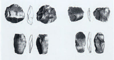
The earliest materials found in our combined expedition were a series of scatters of late Paleolithic artifacts (Fig. 9) found along the present-day coast at Ince Burun. At first we thought that these lithic scatters belonged to a coastal settlement. However, when it became clear that these lithics predated the instilling of the Black Sea we realized that the coast at the time of the late Paleolithic occupation at Ince Burun was nearly 25 kilometers out to sea, and that the lithics scatters represent a highland component overlooking a (now submerged) gentle valley extending north and west. While surveying the submerged coast, in 95 meters of water,
we discovered a rectangular set of squared stone blocks that may be the foundation of a manmade structure (see Fig. 12). If this is confirmed by future investigations, the site may represent the lowland “sister” of the lithic scatter site at Ince Burun. Only actual excavation of the submerged sites will be able to answer these questions.
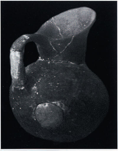
In five years of systematic field walking, our land survey has located more than 170 sites that relate to occupation of the Sinop peninsula after the inundation of the Black Sea and the establishment of the present-day environment. The prehistoric sites are identified by the appearance of handmade pottery. These ceramics indicate that the inhabitants were farmers. What is most interesting is how different the Sinop ceramics are from those in central Anatolia. The pottery (Fig. 10) appears closer in appearance and manufacture to pottery from other coastal regions of the Black Sea and even has analogies with the Bronze Age pottery from Troy at the opening to the Black Sea.
The few sites found in the highlands and those we rechecked from previous surveys were quite different from those to the south, across the mountains. They were not long-term settlements; they lacked the rebuilding that created the “huyuks” (settlement mounds) familiar on the Anatolia plateau. Certainly none of the sites represented the mudbrick tradition of the greater Near East. Instead, the most common evidence of structures consisted of fragments of burned clay daub, presumably from small-scale, individual one-story structures.
Most sites in the coastal valleys were located on the shoulders of gentle bluffs overlooking the valleys. Sites of all periods tend to be small and are rarely superimposed upon another. This pattern of dispersed small sites, which we imagine were individual farmsteads, production areas, or other single buildings, appears to characterize the land use of the Sinop peninsula during many periods—even during the Bronze Age. Both the highland and the coastal valley sites are seldom stratified, although populations tended to return to the same valley period after period. The specialized coastal sites, where occupants engaged in trade and transshipment. appear also to shift slightly in location through time. These port areas form what we call “hotshots,” which mark the beginnings of our projected trade routes. The underwater search for shipwrecks starts from these spots, searching along the maritime space for remains of ships, debris cast off from ships, or other archaeological traces of the trade routes themselves.
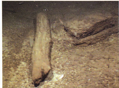
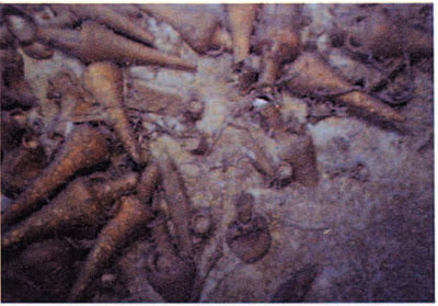
Preliminary sidescan survey of the inner harbor showed that even though we had documented real “hotshots” where we know transshipment occurred, intact shipwrecks had not survived in the harbor areas where bottom net fishing was carried out. However, small debris, such as anchors, amphorae, and other materials identified as sonar “targets,” seemed to occur more frequently along the shipping lanes out of the Sinop harbor (Mindell, Foley, and Webster i998). After a second season documenting the lack of targets in the fishing zone, we predicted that shipwrecks would be found along the proposed shipping lanes beyond the depth of bottom-fishing nets, in waters well below the depths divers can reach and only observable by robotic survey. In September 2000. we surveyed for the first time beneath the level of bottom net fishing and immediately began to find shipwrecks with distinctive Sinopean amphorae and pottery, which were lost along the east-west shipping routes (Fig. II). Of particular interest is the remarkable state of preservation of the ships in the deep water. Not only did these discoveries add to our understanding of ancient ships themselves, they also offer an important record of the economic system of the Black Sea coastal cultures.
The shipwrecks that we have found so far date to the Roman and Byzantine periods (Ballard, Hiebert, et al. 2001). However, it is likely that much older ships will also be found. In our recent excavations beneath the Hellenistic walls of the citadel of Sinop town, we found evidence of Bronze Age building levels, suggesting that seafaring was important thousands of years earlier than the Byzantine shipwreck that we found in this last year’s survey. At least three separate non-continuous building levels were found at this site. This critical spot overlooks both the inner and the outer harbor, and the superimposition of levels is evidence that people returned period after period.
The dispersed pattern of settlement may even predate the earliest known agricultural evidence on the Sinop peninsula. If we are able to confirm with further research that the site submerged in 95 meters of water to the west of Ince Burun (Fig. 12) is indeed a structure rather than a natural collection of objects and artifacts, this would extend the pattern of dispersed settlement thousands of years earlier than we presently know.
It is clear that the Sinop promontory has a long history of occupation. The earliest remains suggest a late Paleolithic occupation—probably a hunting and fishing economy that would have taken advantage of the wealth of resources from the Lakeshore and the highlands in a seasonal pattern. This type of settlement was radically changed by the inundation of the Black Sea and its shift from a freshwater lake to a saltwater sea. In many parts of the southern coast, the coastal plain entirely disappeared.
Conclusions
It apparently took a considerable amount of time for settlement to return to the Sinop peninsula. The long-term shift in environment following the last Ice Age involved the development of modern steppe environments to the north of the Black Sea, and the emergence of the modern vegetation and fauna of the rugged northern Turkish coast along the south coast. When people did return, they apparently came as farmers, and the new economy took some time to establish. By the Bronze Age, we can observe the dispersed settlement pattern across the Sinop hinterland, as well as evidence for the location of sites at critical points on the coast. In particular, coastal sites such as Sinop Kale document repeated levels of pre-classical settlement in the same location overlooking the outer harbor. A coastal culture’s fortunes are tied to other coastal regions that share its specialized economy. In other words, you can’t have just one port. What we see archaeologically as discontinuous occupation may well actually be just that. It may be that the coastal economies of the Black Sea waxed and waned together, creating a sort of “lights on—lights off” effect around the Sea.
This appears to be the pattern prehistorically just as in the historic period. It is interesting that the development of the specialized coastal cultures of the Black Sea may be contemporary with the development of specialized herding on the steppe to the north and the development of specialized hunting and fishing in the forest zone farther to the north (see articles by Shishlina and Emel’yanov elsewhere in this issue). For the Black Sea coastal cultures, trade items reflect this development. We predict that this pattern will be seen in the goods of ships discovered in the deep waters of the Black Sea.
Acknowledgments
The archaeological research of the Black Sea Trade Project, based at the University of Pennsylvania Museum of Archaeology and Anthropology, is conducted in collaboration with the institute for Exploration, Mystic, Conn. I would like to thank in particular Robert Ballard, director of the Black Sea underwater research, and Owen Doonan, director of the land survey at Sinop. This research is sponsored in part by the National Geographic Society and the Samuel Freeman Charitable Trust.
Ballard, R.D. 1993. “The MEDEA/JASON Remotely Operated Vehicle System.” Deep Sea Research 40(8): 1673-87.’Ballard, R.D., D.F. Coleman, and C. Rosenberg n.d. “Further Evidence for Abrupt Drowning of the Black Sea Shelf.” Marine Geology. Forthcoming.Ballard, R., and F. Hiebert, with D. F. Coleman, C. Ward. J. Smith, K. Willis, B. Foley, K. Croff, C. Major, F. Torre, N.F. Miller, and W. Woods 2001. “Deepwater Archaeology of the Black Sea.” Deep Sea Research. In press.
Doonan, O., A. Cantos, and F. Hiebert n.d. “Karasu Valley Survey. 1998-99.” Anatolica. Forthcoming.
Fedoseev, N.F. 1993. “Utochnennyi spisok magistratov. kontrolirovavshikh keramicheskoe proizvodstvo v Sinope.” Vestnik Drevnei Istorii 2:85-104.
Hiebert. F. 1997· “Black Sea Trade Project.” American journal of Archaeology 101:377·
Hiebert, F., D. Smart. A. Cantos. and O. Doonan 1997. “From Mountaintop to Ocean Bottom: A Comprehensive Approach to Archaeological Survey Along the Turkish Black Sea Coast.” In Ocean Pulse: A Critical Diagnosis, ed. J. Tancredi, pp. 177-84. New York: Plenum.
Kassab-Tezgör. D. 1998. “Prospection sous-marine près de la côte sinopeenne: transport d ‘amphores depuis l’atelier et navigation en mer Noire.” Anatolia Antiqua 6:443-50.
Kassab-Tezgör, D., and I. Tatlican 1998. “Fouilles des ateliers d ‘amphores a Demirci.” Anatolica Antiqua 6:42 6-42.
Mindell, D., B. Foley, and S. Webster 1998. “Black Sea Survey 1998: Cruise Report.” Manuscript on file at Massachusetts Institute of Technology and the Institute for Exploration, Mystic, Conn.
Ryan, W., and W. Pitman 1998. Noah s Flood: The New Scientific Discoveries About the Event that Changed History. New York: Simon & Schuster.
Ryan, W.B.F., W.C. Pitman III, C.O. Major, K. Shimkus, V. Moskalenko. G.A.Jones, P. Dimitrov, N. Gorur, M. Sakinc. H. Yuce 1997· “An Abrupt Drowning of the Black Sea Shelf.” Marine Geology 138 :119-26.
Shishlina. N. 1987. “O kamennikh izdeliiakh Borodinskogo klada.” In Aktual ‘nie Problemi Istoriko Arkheologicheskikh Issledovanii. pp. 178-79. Kiev: Nauka Dumke.
Treister. M. 1996. “The Trojan Treasures. Description, Chronology. Historical Context.” In The Treasures of Troy: Heinrich Schleimann’s Excavations, pp. 197-234. Moscow: Pushkin State Museum of Fine Arts.
Weigland, G. 1958. “Some Elements in the Study of Port Geography.” Geographical Review 48:185-200.
Whitcomb, D., and J. Johnson 1982. Qusier al-Qadim 1980. ARCE 7· Malibu, CA: Undena.
