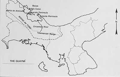
The provinces of Bocas del Toro and Chiriqui in western Panama are the homeland today of 35,000 Guaymi Indians who occupy a territory rich in archaeological remains. Unless we invent vanished tribes of yesterday and hypothetical migrations—neither of which seems warranted by our records—the archaeological sites were made by ancestors of the Guaymi. Ethnic continuity is more marked in Bocas del Toro, where early contact with the Spaniards was slight and intermittent, than in Chiriqui where Indians of the coastal plains suffered early decimation, or were pushed far up into the highlands. Bocas del Toro (henceforth Bocas) offers ideal conditions for the use of ethnographic analogy in the reconstruction of ancient settlement patterns and subsistence activities. Here prehispanic cultures merged imperceptibly with societies described in the chronicles, and the descendants of these people, the Guaymi, still live in the same area using the resources of the land and sea in ways virtually unchanged from the past. Precisely for this reason, Bocas has been chosen as the starting point for an ethno-archaeological project of several years’ duration. Support for our research comes from the National Science Foundation (NSF-Gr-2846), with additional funds for American and Panamanian graduate students in archaeology corning from the Ford Foundation traineeship grants administered by our University of Pennsylvania Museum. It is to the results of the first season’s work in Bocas (January-May 1970) that I address myself here. But first let me give you a background of the area, its inhabitants and their history.
Remembering that Panama runs east to west and not north to south as is often assumed, Bocas then is in the northwestern half of the Isthmus, facing the Atlantic or Caribbean coast. Dividing it from the adjacent province of Chiriqui to the south is a steep mountain range with peaks up to eleven thousand feet. They form an effective barrier for moisture-laden winds from the northeast which drop their waters on the northern side, making Bocas one of the most humid tropical areas in Latin America. Average annual rainfall along the coast is 138 inches (roughly eleven feet!), and it rains even more on the northern slopes of the Talamancan range. As we were soon to discover, there is no dry season, the entire province being covered by a dense tropical forest growth.
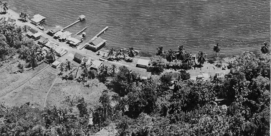
The ecology helps explain why Bocas has always been thinly populated. With roughly twelve percent of Panama’s total surface area, its 40,000 inhabitants are only three percent of the national population. And most of them live in an embayment formed by the Bahia de Almirante and the Laguna de Chiriqui (which is in Bocas, not in Chiriqui). Chinese traders and Jamaican fishermen are concentrated in two cities called Almirante and Bocas. The small rural farming population is either Jamaican creole in extraction or typical Panamanian mestizo peasants. Newcomers to this area in the last two hundred years, they have tended to settle in small towns along the coast in the Bahia de Almirante, where they build pile dwellings on the water’s edge and engage in cash crops such as cacao, or migrate to the United Fruit Company holdings to work for wages. Since there are virtually no roads anywhere in Bocas—except for town streets—all internal travel is by water. In any normal day the Bay is covered with large plank canoes, going and coming with products from the mainland to trade in island towns.
Completely isolated from these more recent immigrants are the 12,000 Guaymi living in restricted areas of the Bocas Province. They are found either along Valiente Peninsula or along the ridges bordering the Cricamola River, far into the highlands. Scattered hamlets are also built in the Bahia de Almirante. Seldom found living at the water’s edge, the Guaymi of Bocas prefer instead to build their pile dwellings on hills and ridges inland from the coast. Since most of Bocas is devoid of beaches or coastal plains, settlement alternatives are on ridge tops or on pile dwellings at the very edge of the sea. Among all of the Guaymi, those of Bocas are the most traditional and isolated. Their scattered hamlets in jungle clearings are often kilometers away from each other. This dispersed settlement pattern accords well with their forest-fallow, slash and burn agriculture system. A plot of land is cleared and planted with diverse root crops and sometimes a flint corn used to feed pigs; when it gets overgrown by weeds and difficult to clear, it is abandoned and a new plot opened up from the jungle. The ratio of land to people is low, especially around Almirante Bay, where Guaymi hamlets are less numerous because of their proximity to towns inhabited by “foreigners.”
Historically, the first description we have of Indian people living in Bocas comes from the account of Christopher Columbus’s Fourth Voyage (in May 1502 to November 1504) written by his son, Fernando Colon, who as a boy of thirteen accompanied Columbus on this voyage. This was the first time that Spaniards touched the American mainland, their previous voyages having been restricted to the Caribbean islands. After sailing along the coast of Honduras, Nicaragua, and Costa Rica, Columbus’s ships finally docked in Almirante Bay, at Isla Colon, which the inhabitants called Cerebaro, a Guaymi name.
Mistaking the name of this island for the entire bay, Fernando Colon in his account gives the following description:
Wednesday, October 5th, the Admiral set sail and proceeded to Cerebaro Bay, which is six leagues long and more than three wide; it is studded with islands and has three or four channels that are very convenient for getting in and out with every kind of wind. The ships sailed as in streets between one island and another, the branches of the trees brushing the cordage of the ships. After we had anchored in this bay, a landing was made on one of these islands. The boat’s people found twenty canoes beached on the shore, and encountered Indians who were as naked as they came from their mothers’ wombs. Some wore only a gold mirror at the neck, and others a guanin—i.e. tumbaga—eagle. They showed no fear, and with the aid of the Indian interpreter from Cariay(Puerto Limon, in Costa Rica) . . . they traded a gold mirror weighing 10 ducats for three hawk’s bells; they said this gold was very abundant and they got it from the mainland, not far from there. (Keen, p. 241.)

cooking at the camp site.
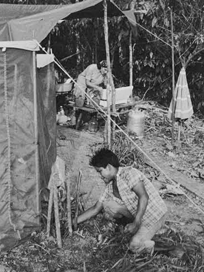
clearing the area around camp.
More information from the Indians was obtained by Columbus and his crew the next day when they touched on the mainland:
The Indians said that one or two days’ journey inland much gold was found in certain places that they named; they said, too, that there were many fish in that bay, and ashore many of those animals that we had seen in Cariay and many of the things the Indians eat, such as roots, grains and fruit. The Indians are painted all over face and body in different colors, white, black and red. They go completely naked, only covering their genitals with cotton clouts. (ibid., p. 242.)
Although his account does not go into details about the material culture of these Indians, Fernando Colon mentions that they lived dispersed in single dwellings or hamlets along the courses of rivers, ridges, and hills rather than on the coast. From his accounts and those that followed there is very little doubt that the Indians encountered by Columbus were the ancestors of the Guaymi, whose settlement patterns and subsistence activities remain largely unchanged.
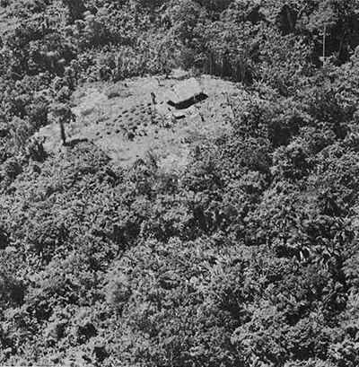
from the Cerro Brujo site.

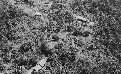
Going back further in time, Bocas is rich in archaeological sites. Numerous shell-middens dating roughly from A.D. 500 to the time of the Conquest are found in the Bahia de Almirante on ridges away from the coast, at elevations ranging between 300 and 1000 feet. One of the areas where ancient shell-middens abound is on the Peninsula de Aguacate which forms the western arm of Almirante Bay. In spite of large trees and tangled growth, sites can be located by the ancient shells which are strewn on the surface of low mounds. These also contain other human refuse, such as potsherds, battered ground stone implements, and the bones of many animals. I have often been asked how it is possible for bones to be preserved in areas of so much rain. The answer, of course, is that shell neutralizes acid soils, raising their pH (relative alkalinity-acidity) and creating a balanced condition whereby bones are not reabsorbed. This phenomenon, in fact, explains our interest in shell-middens, for it is only in this type of site that we can hope to recover mollusks and faunal remains, so important in reconstructing ancient dietary patterns and food-procuring activities.
Peninsula de Aquacate, Bocas del Toro.
In the course of hunting treks, or when clearing land, Indians and mestizos living today in Aguacate Peninsula have noticed these shell heaps oddly placed far away from the coast. Thanks to their aid as guides—and later as workmen—it was possible in 1969 to locate the site of Cerro Brujo (CA-3), approximately two kilometers inland from the coast, on a ridge five hundred feet above sea level. During the following season, this spot became the seat of our excavations. We pitched camp on a ridge below the main site, very near the home of a Guaymi friend and his family. Our close association with them, and our efforts to cope with local conditions, gave us a feeling for the ecology. When we think back on our camp, perpetually in need of weeding as grass and bush grew tall in three months, we can imagine why the ancient settlers of Cerro Brujo found it easier to move their house periodically rather than fight the secondary growth around their hamlets and their fields. Drenched as we were by unrelenting rains, we also came to understand why no serious archaeological work had ever been done before in Bocas. Trenches had to be kept constantly covered with tarpaulins lest they be ruined by the incessant rain. Our instruments were a source of worry as fungi threatened to attack the lenses, and every perishable item brought in, including the tents, was soon decomposing under our feet. Nonetheless, to say that these conditions affect the present-day Guaymi and their ancestors as adversely as they did us is to overstate the point and completely lose sight of their skill in adapting successfully to tropical forest conditions. Just how they managed to do this can best be explained by describing the site, our excavations, and the preliminary results of our analysis.

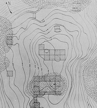
Cerro Brujo (CA-3) consists of five scattered shell-midden clusters within an area roughly one kilometer in diameter. Since all five midden clusters contain refuse, particularly pottery, dating from the more recent of two periods, we have assumed with some confidence that they were occupied simultaneously by scattered households, like those forming a single Guaymi hamlet today. Although we chose the largest of the mid-den clusters (CA-3a) for extensive excavation, the others were also tested.
Site CA-3a is on a very small flat ridged area that slopes off abruptly on three sides except at the southern edge where a fairly large shellmidden was found. Other middens grew along the peripheries from refuse thrown downslope by the inhabitants. The flat area in the center was occupied by one large, or at most two houses. Here we found stone tools and pottery but no shell refuse.
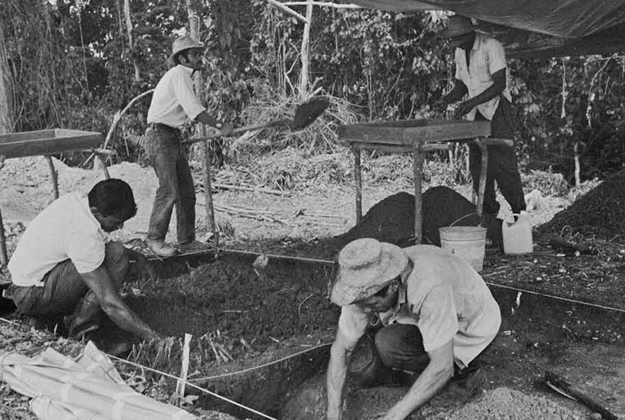
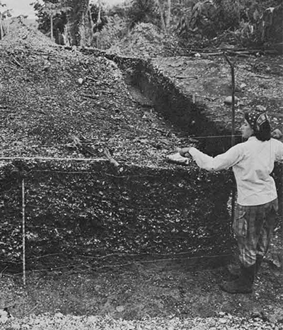
One hundred and eighteen square meters of this tiny hamlet was excavated in an effort to reconstruct the pattern of activities carried out in different portions of the site at different points in time. In general, excavations proceeded by natural stratigraphy and deposits seldom exceeded a meter and a half in depth. All soil and shell was screened through 1/5 inch mesh.
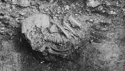
At the end of the season we had recovered more than 10,000 animal bones, several tons of shell and soil from column samples, over 200 stone artifacts, and nearly 20,000 potsherds, plus a few esoteric artifacts such as shell pendants, shell trumpets, whistles and the like. Not surprisingly, we didn’t find a single ornament of gold since this was a modest habitation site, not a cemetery. This is not to say that human skeletal remains were absent, for we found the burial of a child and that of an adult with the lower part of his body missing; disarticulated human bones were also found throughout the refuse. Even though the analysis of all excavated materials is still in process, we can give at this point a very general description of the lifeways in this area before the arrival of the Spaniards.
The inhabitants of Cerro Brujo were probably slash and burn cultivators like the Guaymi today. Studies and analyses of soil samples have not been completed, but we expect to find root crops such as sweet manioc (known also as cassava, where tapioca comes from) nampi (a Discorea), and “elephant’s ear,” a type of taro grown in the New World. We know that maize was grown (its pollen is large and easy to detect), but its importance at that time has not yet been determined.

Shellfish gathering, another subsistence activity, was in all likelihood peripheral. Huge quantities of mollusks can be gathered in a very short time. Column samples show a total of twenty-five species, only five found throughout all stratigraphic units. These were bivalves growing in large quantities in intertidal shallow waters and could be easily and quickly harvested from ocean beds in the bay. Since Cerro Brujo is fairly far inland, mollusks were brought intact to be shelled, cooked and consumed at the hamlet. The Guaymi today still gather mollusks from shallow beds and dive for them in the bay, but shell-middens are no longer formed since the importance of shell fish as food has diminished.
Of greater value as food were animals, both marine and land species. Fish, as well as turtles, ranged in size from a few pounds to giant sea species. Also common in our collections are bones of large birds such as kingfishers or cormorants. Among land animals found in our collections we can name the armadillo, large rodents known as agouti and paca, peccary and Virginia deer. We expect to find several other species such as the brocket (or small forest deer) and the tapir, both common today. The largest mammal so far identified is the manatee or sea cow, described by Ferdinand Columbus as follows:
The second fish was caught by another means: the Indians call it manatee and it is not known in Europe. It is as big as a calf and resembles one in taste and color, but it is better tasting and fatter; and those that believe that all manners of land animals live in the sea argue the manatee is not a fish but a calf, since it does not look like a fish and feeds only on the grass it finds along the shore. (Keen: From The Life of the Admiral Christopher Columbus, Ch. 89, p. 230.)
Survival was dependent on the use of stone tools, many of which were recovered in the excavations. Celts, and the only axe found, were probably employed in the girdling of trees. Smaller tools which we classify as adzes were used for lighter woodworking, such as shaping canoes. Celts were reused as hammerstones, and only when completely worn down were discarded in the refuse. The bulk of flaked tools consisted of blade and blade fragments, probably used as knives for skinning and quartering animals. The only projectile point in our entire collection is a small triangular arrowhead, suggesting to us that most hunting, and probably most fishing also, was done by spearing with spearheads made from the tough chonta palm, used by the Guaymi today for precisely these activities. Aside from use, perhaps the most important feature of the stone tools found at Cerro Brujo is the fact that none of them had been manufactured at the site. Raw materials, largely basalts, are of highland rather than local provenience, and of the seventy or so flakes encountered locally most were the product of crude resharpening attempts, or were produced accidentally in the process of use, not manufacture. So far, our best interpretation is that tools were imported from the highlands of Chiriqui—where large prehistoric quarry sites have been located—and exchanged against fish, mollusks and such valuable items as shell trumpets produced by the Cerro Brujo group.
So far, the pottery shows little variation through time, except for the bottom layer where a dark soil but no shell was present. A red-slipped distinct ware was isolated in this layer, but the rest of the shell-containing strata had a crude brushed ware and pottery types common on the Chiriqui side of the Isthmus. From recent radiocarbon dates we know that the most recent occupation of the site, characterized by the abundant shell and crude pottery, lasted only about 100 years, from A.D. 900 to A.D. 1000. If the bottom occupation was much older we still don’t know; but in all likelihood it lasted just as short a time. Undoubtedly the short duration of both occupations had to do with complicated social and ecological factors. What these were, and how they may have influenced the choice of habitat and the pattern of activities at Cerro Brujo we hope will become more clear when we compare their remains with those we shall be finding in the second year of fieldwork, this time on the Pacific side of the Isthmus, where a real dry season does exist.