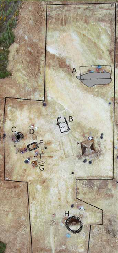
- This artist’s reconstruction shows the seasonal work building at San Martino, which dates to the late 1st century BC
- The Roman peasant’s landscape in Cinigiano, Tuscany, with one of the authors’ excavations in the foreground. The highly varied terrain is typical of the region and provided a number of different ecological zones that could be exploited by peasants. The continued prevalence of wheat farming here has meant generally shallow plowing and thus better preservation of archaeological remains beneath the surface.
- In the shadow of the medieval castle of Porrona, the Roman Peasant Project excavated its first site, the farm of Pievina.
We view the Roman world through the eyes of the wealthy—the lettered elite who penned ancient history and literature, and the ruling classes whose monies built Roman cities and monuments. The poor are nearly invisible to us, their textual and material traces ephemeral, in many cases nonexistent. This is particularly true of the rural poor: by some estimates the rural poor constituted some 90% of the overall Roman population, and yet their textual traces are limited to a handful of laws, asides in agricultural handbooks, and some images. The richest potential source for these persons is archaeological evidence, but Roman archaeology has been largely disinterested. With some few exceptions, archaeologists have principally excavated the opulent and visually striking rural villas of the landowning rich. The humble farmsteads of the rural poor—less beautiful to look at, but arguably more critical to an understanding of Roman society—have been for the most part ignored. There exists no real archaeology of these lower classes, and thus our understanding of their homes and farms, their diet and agricultural methods, and even their relationship with their landscapes is extremely limited.
We began the Roman Peasant Project to try to answer some of these questions. The result of a collaboration between four young archaeologists at the University of Pennsylvania, University of Cambridge, and the Università di Siena/Grosseto, the Project constitutes the first organized attempt to excavate the houses and farms of peasants living between the 2nd century BC and the 6th century AD. By revealing the buildings in which they lived and worked, by analyzing the seeds and animal bones that remain of their meals, and by mapping their local resources, we hope to reveal the lived experiences of this largest, most invisible group of ancient Romans.
We also set out to challenge perceptions of what it meant to be a “peasant” or “poor” in the Roman world. Most historians have assumed that Roman peasants lived hand to mouth, producing only enough food to survive and living at the mercy of great landowners. We suspected this was too simple. Inspired by new economic studies on the modern poor, we hoped that analyses of the ceramics, coins, animal bones, and geological materials from peasant sites would show that Roman peasants not only drew on local resources, but were simultaneously engaged in broad, even global economic networks. Contrary to most historical studies which emphasize the oppression of this group by wealthy elites, we assumed instead that the principal force in these peasants’ lives was not the imposing figure of a distant landlord, but their own peers, while mutual dependency, through the small-scale exchange of basic foods and consumer goods, was as potent a factor as hierarchical exploitation.
A People without History: Finding and Excavating Roman Peasant Houses
But how does one find the farms and houses of the Roman peasant? While they may have been largely ignored by excavation, their whereabouts are hardly unknown. Surface field survey reveals their presence at every turn. The majority of sites uncovered in most archaeological field surveys are small scatters of ceramics and roof tiles, under 0.5 hectares in area. Even smaller scatters of surface material, often termed “off-site scatters,” are similarly numerous. Field-survey archaeologists typically place these small “sites” and “off-sites” at one end of a size-based site spectrum, at the opposite end of which are the great villas. Between the two are other forms of small sites, such as small agglomerations or mini-villages. These small sites almost certainly represent the farms, huts, outbuildings, and villages of Roman rural non-elites. We may imagine that the wide spectrum of size, relative wealth, and configuration suggested by the surface evidence is paralleled by the many social classes who are known from the textual sources that we term “peasants”—agricultural slaves, tenants, wage-laborers, overseers, and traders.
Yet while field surveys throughout the Roman Mediterranean have revealed thousands of such sites, and a handful of examples have been excavated, they have seen no systematic analysis or programmatic study. We hope to excavate up to ten of these sites over a five-year period. These will include the tiniest hut to the larger village, revealing the rich diversity of what it meant to be a Roman peasant.
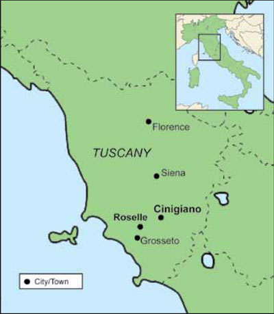
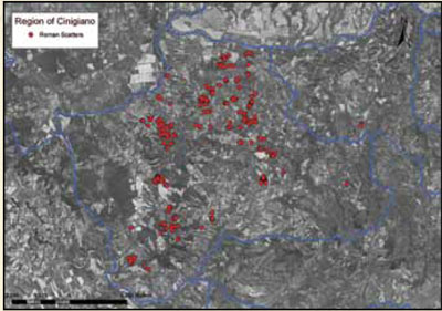
The Project is based in the small township of Cinigiano, in western Tuscany, an optimal landscape for such an endeavor. One of the Project’s co-founders, Mariaelena Ghisleni, has spent the last three years doing surface and geophysical survey in the township and has uncovered over 500 new archaeological sites. She found that unlike the better-studied coastal region around Cosa and Roselle, areas rich in elite Roman villas, inland Cinigiano was dominated in the Roman period by small sites that represent the farms and houses of the rural poor. Also unlike the coastal region, which has been subjected to deep plowing, these sites are generally better preserved. As a consequence, the potential rewards to be gained by systematic excavation are great.

But how can one be sure that these scattered remains of surface pottery actually represent preserved peasant houses? One way is to undertake geophysical survey prior to excavation. By using various forms of magnetometry, the Project tries to determine the extent of plow damage, and test the special relationship between subsurface remains and surface scatters.
Once the sites are confirmed, the Project excavates them somewhat differently from traditional archaeological projects. Many digs linger for decades over a single site. For our project this is not an option, as the farmers who generously allow their fields to be excavated need their land back so that they can plant it again the following agricultural year. The Project is also based around the principle that excavating one site does not reveal much about a whole subsection of the population: rather, many such sites must be excavated. Thus, each of the small sites is excavated in about 30 days, or sometimes less.
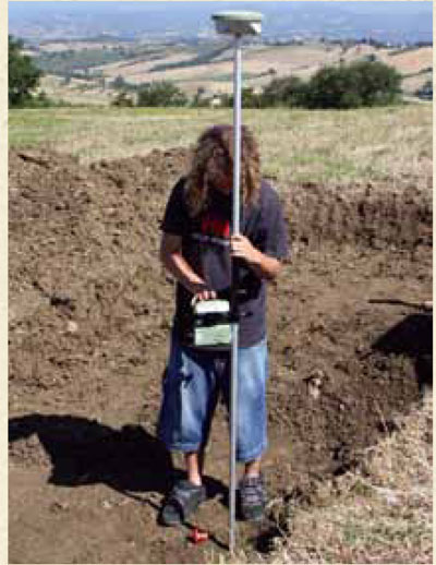
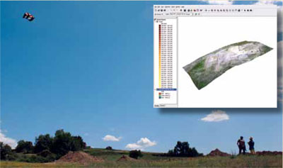
We use relatively large teams in small areas, and make maximum use of modern technology, like employing highly accurate GPS systems to map finds, which cuts down on laborious hand-drawing. We also use high-resolution aerial kite photography to produce quick overall site views which, when “draped” over a detailed topographic survey, produce three-dimensional site sketches and can also be used to shorten hand-drawing of walls and other features.
Proving It Can Be Done: The Excavation of Pievina
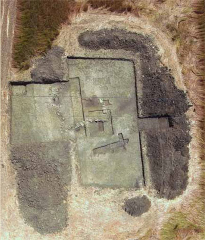
In June 2009, the group put their theories and new methods to the test, excavating a pilot site called Pievina, about 3 km from Cinigiano itself. The site had been located during field survey and subsequently subjected to geophysical survey. At about 1.5 ha of dispersed remains, the site lay at the “large” end of the peasant spectrum and was composed of seven distinct concentrations of materials and thus interpreted as a small village with its own ceramic kiln. The fact that the field was scheduled for transformation into a vineyard—a process which would have destroyed the site—made it a particularly attractive place to begin. When the landlord generously offered the Project an opportunity to excavate before the plantings, we jumped at the chance.
In 20 work days, the team, composed of 20 American and Italian students, excavated about 30% of the site. We uncovered a well-preserved farmstead, with two major but distinct phases of occupation, intact stratigraphy, and a rich collection of ceramics, coins, and animal bones. The geophysical results proved to be hyper-accurate, correctly pinpointing not only the general location of the major remains and the kiln site, but even showing the smallest post-holes. The Roman peasant, it turned out, could be found and excavated quickly and accurately.
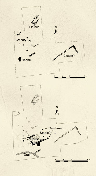
But these were not Roman peasants as historians had imagined them. In the early 1st century BC, the farmstead possessed a large cistern, a possible granary for the storage of wheat, and a kiln for producing tiles. We never found the house that went with this farm, which probably lay in the unexcavated areas to the north. The granary, some 12 m in length, would have held surplus grain beyond family needs, either for tax payments or local sale, possibly by a collective group. While much of the stone for their buildings came from local (2–12 km distant) sources, the millstones to grind the grain were carried from special quarries over 60 aerial km away, perhaps near Orvieto. Their cooking and dining wares arrived from regional sources along the Tuscan coast, while a modest collection of coins suggests these peasants were plugged into a monetized economy. In short, peasants from the age of Cicero were not engaged in mere “subsistence” living, but were producing surpluses, paying in coin, and tied into a much broader economic world.
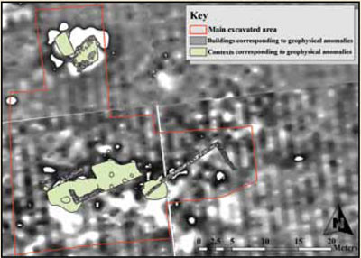
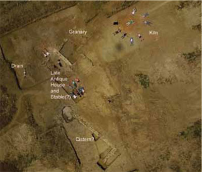
At some point in the late 1st to early 2nd century AD, the farm was abandoned and covered by a major earth movement, perhaps the slump of the adjacent hill. Two centuries later, in the later 4th century, its ruins were reoccupied by a new family. This household reused the walls and the roof tiles of the old farm to build a much smaller house, to which was appended a post-built wooden structure, perhaps a stable. The granary was abandoned, as was the kiln, and the family lived almost atop heaps of their household garbage—all initially suggesting that these peasants’ economic world had contracted and their quality of life declined. Yet the quantities and origins of their cooking pots, tablewares, and coins were surprisingly rich. Unlike their Republican-period predecessors, this family had access to a much wider range of domestic goods, from North African olive oil shipped in amphorae to relatively large quantities of low-value coins. Indeed, the tablewares they dined on were almost equal in variety to those used by occupants of the nearest city—Roselle. Their house may have been smaller and surrounded by garbage, but like the peasants of modern Third World countries, with satellite TV and cell phones, they, too, were connected to a globalized economy.
While the Pievina peasants may have shopped globally, they ate locally—at least as far as their animal diet was concerned. Analysis of the animal bones indicates a diet distinct from rich villa sites: far lower in pig, a staple of Roman elite diets, and considerably richer in old, tough cattle. The cattle evidence is important: some scholars have thought Roman peasants were so poor they could not even afford work oxen. Clearly this was not the case at Pievina, where oxen were worked until they reached old age and then slaughtered. The most commonly eaten animals, however, were sheep and goats, species which provide one-stop-shopping for milk, wool/hides, and meat. While the pots and coins describe a world with access to a Mediterranean market, the animal bones reveal one of scrimping and saving, making careful use of each animal’s productive life.
Commuting Peasants, Cooperative Peasants
While in general a success, there were problems with this first pilot season. We realized in retrospect that the site we chose was too monumental to provide a real test of the geophysics, too big to be completely excavated in a short season, and too rich to really represent the poorest of the poor. We also wondered what role the great distance of the site from the region’s only villa might have played in its obvious prosperity. Were these peasants able to operate relatively independently of landlord control and thus enrich themselves?
Our next season in 2010 thus focused on two very different kinds of sites: a very small (15 x 10 m) scatter of 1st century BC date (San Martino), and a complex of three 10 x 10 m scatters located some 500 m from the villa (Case Nuove). This second season allowed us to further test our working methodologies and began to suggest a rather different kind of peasant settlement landscape than we, or others, had assumed.
San Martino was revealed to be a somewhat plow damaged, but largely intact small (8 x 8 m) rural shelter with a single-pitch thatched roof, clay walls, and beaten earth floor. Dating to the late 1st century BC and occupied for only a short period, the absence of faunal remains, cooking installations, and significant ceramic rubbish suggested to us that this was not a house, as we initially thought, but a seasonally occupied work building. Set in a valley of prime agricultural land and facing the prevailing northern winds, the structure may have been used in the summer months during grain harvest. Those who used this work building may have come from a contemporary village, located through field survey 1 km along the valley.
Case Nuove revealed yet another site type—a small scale agro-processing point. The site was established on a hilltop during the late 1st century BC through the 2nd to 3rd century AD for the processing of some agricultural product. A waterproof work surface, processing basin, storage jars, a storage silo, a cistern, and post-holes for a possible press point to oil or plant-fiber processing. Residue analysis on the dolia (storage jars) and work surface, carried out by Alessandra Pecci of the Equip de Recerca Arqueológica e Arqueomètrica de la Universitat de Barcelona (ERAUB), has indicated the presence of some kind of vegetable oil, but not necessarily olive oil. Although the whole of the hilltop was surveyed and excavated, no habitations were found. This, plus the waterless hilltop location pointed to a purely industrial site. Given the small size of the processing tanks (one of the smallest ever excavated from the Roman period in central Italy), we believe the Case Nuove site represents a collective pressing point, much like the modern cantine in Italian villages to which small proprietors take their harvest to be processed.
Both of these sites are surprising for what they do not represent. We had assumed, along with scholarly consensus, that the small surface scatters at San Martino and Case Nuove would reveal peasant houses. In fact, none of the sites we have excavated conform to the standard notions of a single-structure peasant farmstead. Not only were peasant socio-economies more diverse than we supposed, but it now seems that, at least in this region, peasants inhabited and utilized a wide variety of functionally diverse, possibly complementary sites. This in turn suggests a mobile peasantry, exploiting distant and functionally distinct spaces. Furthermore, the paucity of habitation space in our excavations to date may indicate that the smallest surface survey sites are not the real homes of the peasantry in this region. Rather, it is possible that these sites were used periodically by a “commuting” peasantry that lived in the posited agglomerated villages.
Peasants in Their Environment

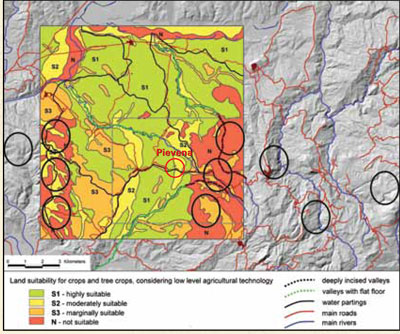
The environmental analysis from both seasons reveals in detail how the inhabitants of these sites exploited their landscapes. For each site we excavate, we produce what is termed a Land-Units map—sections of territory with coherent and homogeneous soil, substrate, geomorphology, hydrology, and topographic characteristics. These Land-Units in turn permit the reconstruction of basic soils viability, forestation, human mobility opportunities and challenges, and possible geological resources. We also track down the probable topographic origin of each stone used in our sites’ structures.
This data has already provided some suggestive conclusions. For instance, the two excavated 1st century BC buildings (Pievina Phase 1; San Martino) are composed of stone types derived from a variety of sources, both proximate (1–3 km) and distant (10+ km). The distant sources are almost all in areas challenging to access, involving steep slopes and difficult stream crossings, and typically with relatively poor soils. This indicates the collection of building stone over time from various points in the landscape, implying a mobile peasantry. Our analysis has further revealed that good agricultural soils around both sites are highly clayey, heavy, and thus difficult to plow except during the fall months. A major reliance on plow animals to work these soils is further indicated by the relatively high number of cattle remains.
More unexpected results are coming from initial pollen analysis carried out at Case Nuove and San Martino. While Case Nuove today is set in a partially wooded landscape, the pollen analysis reveals that in Roman times, the wood might have receded. Pollen associated with vines and olives was also very low. Instead, pollens associated with pasture plants, selectively maintained by animal grazing, are among the most numerous. Taken together with the animal bone evidence from the first season at Pievina, it would seem that pasturage and pasture animals—sheep and goat—dominated this peasant environment. We must remember that the pastures detected by the pollen analysis are not “natural”—their ecology is formed by the selective grazing of animals. Thus, the peasants’ pastoral landscape was very much shaped by their own animal husbandry choices.
Looking to the Future
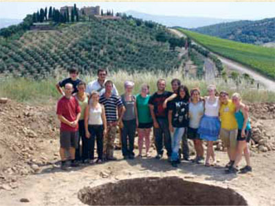
The Project hopes to continue to excavate two sites per year for the next five years, continuing this summer (2011) with a Penn Museum field school, run in collaboration with the School for Liberal and Professional Studies, designed to teach basic field practice to Penn undergraduates. By the end of this period we hope to have assembled the first-ever collection of archaeological data on peasants’ lives, diet, and landscapes in Roman Italy. It is a small start, perhaps, but represents an attempt to restore to the archaeological and historical record the 90% of the population which has too long remained in the shadows.
Kim Bowes is Associate Professor in the Department of Classical Studies at the University of Pennsylvania.
Mariaelena Ghisleni has just finished her doctoral thesis at the Università di Siena/Grosseto.
Cam Grey is Assistant Professor in the Department of Classical Studies at the University of Pennsylvania.
Emanuele Vaccaro is Marie Curie Post-doctoral Researcher at the MacDonald Institute of Archaeological Research, University of Cambridge.


