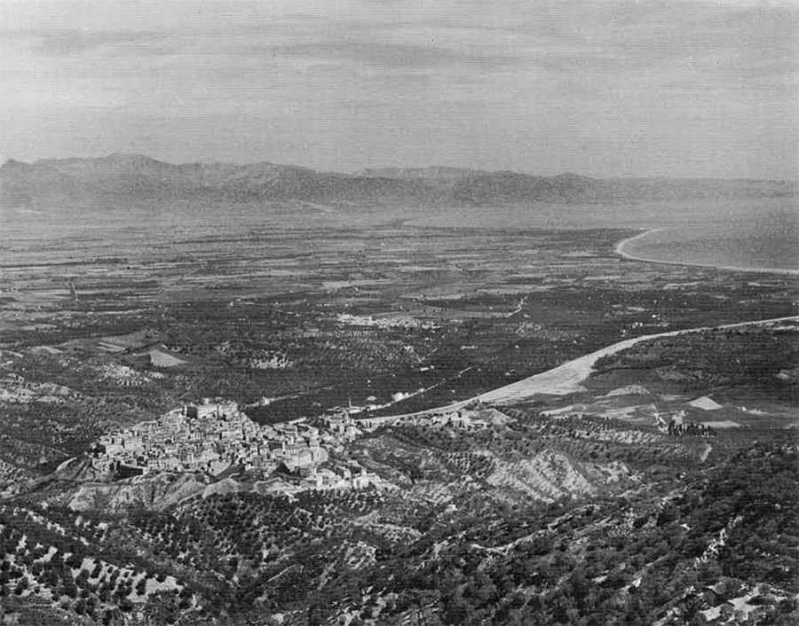
Down in the foot of Italy, or more accurately under the instep and facing the blue Ionian sea, lies the Greek city of Sybaris–virtually untouched by the archaeologist’s spade. Famed ever since antiquity for its great wealth and luxury (our expressions “sybarite” and “sybaritic banquet” acknowledge this fact), Sybaris has held the attention of historians and archaeologists for many centuries. But long before the beginning of modern archaeological research Sybaris had become a lost city, a square mile of buildings buried without a trace somewhere in the silt of an eighty square mile alluvial plain.
This article is a report of the novel methods used in 1962 by the University Museum in prospecting for this elusive city. In order that the reader may understand why we had to use such unorthodox methods, a fair amount of background information is presented first.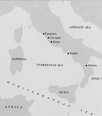
The brief but fascinating history of Sybaris, its importance, and its approximate location can be pieced together from the writings of a number of classical authors, chiefly Athenaeus, Diordorus Siculus, Herodotus, Pliny, and Strabo. One of the earliest of the Greek settlements in Magna Graecia (Southern Italy and Sicily), Sybaris was founded about 720 B.C. by Achaean colonists. Building their city between the Crathis (modern Crati) and Sybaris (modern Coscile) rivers on a vast and fertile coastal plain in northern Calabria, the Sybarites prospered rapidly by agriculture and trade, and grew mightily in numbers, largely by controlling or granting citizenship to members of the native tribes of the interior. An important factor in her prosperity was the fact that she lay at the southern end of overland trade routes leading north and west to her colonies on the Tyrrhenian side of Italy, the most famous of which was Poseidonia (Paestum). It would appear that trade between the Ionian Greeks and the Etruscans was amicably and profitably handled by the Sybarites, for it is said that they came to like the Etruscans among the people of Italy, while among the people of the East they liked the Ionians, because (as Athenaeus remarks disparagingly) both were devoted to luxury.
The picture we see of Sybaris at her peak is a colorful one. Ancient writers stress in a rather puritanical matter the luxurious way of life of the Sybarites, but some of their practices seem quite reasonable to modern city dwellers. For instance, they banned noisy occupations like blacksmithing, carpentry, and chicken-raising from the confines of the city. Streets leading into the country were roofed over to protect travelers from the excessive heat of the sun. Anticipating our oil pipelines and aqueducts, they are said to have piped wine from their country estates to wine cellars near the sea shore, whence it was carried to the city in boats.
The ever increasing wealth of Sybaris inevitably bred an indolent upper class devoted to self-indulgence. Public banquets were held at frequent intervals, and cooks who concocted the best dishes were rewarded with golden crowns–and copyrights to protect their recipes for a whole year. Their attitude toward the Spartan way of life is mentioned by several sources. It is said that a Sybarite who had sojourned in Sparta and had been entertained among them at their public mess remarked, “It is no wonder that Spartans are the bravest men in the world, for anyone in his right mind would prefer to die ten thousand times rather than share in such poor living.”
The final undoing of the Sybarites, resulting in the total destruction of the city, is attributed by some to their having trained horses to dance at their feasts to the accompaniment of pipes. In the words of Athenaeus, “Now the people of Croton knew this when they made war on the Sybarites, as Aristotle records in his account of their construction, and struck up the dance tune for the horses; for they had with them pipers in military uniform; and no sooner did the horses hear the pipers than they danced away, and not only that, but with their riders on their backs they deserted to the people of Croton.”
Whether this story is true or not, we know that Sybaris was destroyed about 510 B.C. by Croton, her next door neighbor and rival to the south. Strabo says that the river was diverted to flow over the ruins. An abortive attempt to resettle the area by the Sybarites was followed by the establishing of a colony in 446 B.C. in the same place by Athenians, who named their new city Thurii. Some two hundred and fifty years later, in 196 B.C., Thurii came under the domination of Rome and was rechristened Copia Thurii. Undergoing a steady decline, this final city was ultimately buried by the accumulating silt of the two rivers. By the nineteenth century A.D. all traces of settlement were gone, the exact location was forgotten, and the area was a badly drained malarial swamp.
The first archaeological expedition to search for Sybaris, led by F. Cavallari in 1879, investigated mainly the higher land on the margins of the plain, discovering several burial mounds of the city of Thurii. For the next fifty years only isolated burials and country villas of the later cities were found. However, the great moment seemed at hand in the early 1930’s when the government in the course of land reclamation dug two great parallel drainage ditches, fifteen feet deep and five miles long, down through the heart of the plain to the sea. But not a single trace of Sybaris and only inconsequential remains of the period of Thurii were found. This fact has been a warning to archaeologists that test trenches, even on a colossal scale, may not suffice to detect the location of Sybaris.
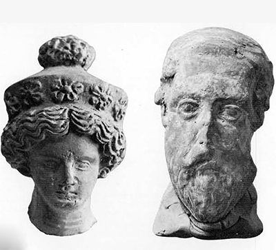
The first objects attributable to Sybaris came to light in the shape of an archaic head and other pieces of archaic sculpture found in otherwise purely Roman material excavated by U. Zanotti-Bianco in 1932 from a semicircular late Roman building located about two kilometers inland from the mouth of the Crati river.
In 1949 I made studies of the archaeological and historical evidence concerning the location of Sybaris, followed by geological and geographical reconnaissance in the plain. These studies led to the conclusion that Sybaris must lie on both sides of the present Crati, some two to four kilometers from its mouth and between the two drainage canals referred to above. Since the Sybaritic stratum was presumed to lie at a great depth below the surface, and since the ground water level lay only a meter or so from the surface, some method of archaeological prospecting other than the digging of test pits seemed advisable. The digging of artesian wells in the plain inspired me to adopt earth boring as a technique for the exploration of the chosen area. With the constant encouragement and advice of Ermanno Candido, a local engineer who in the course of reclaiming large areas for the cultivation of rice had become fascinated with the problem of Sybaris, I made five borings in the Casa Bianca area in 1950. In the fourth of these borings a ten-meter column of earth was extracted, revealing upon analysis, in stratigraphic order, Arrentine pottery and other artifacts of the Roman settlement, Hellenistic and Attic pottery of Thurii, and East Greek pottery of Sybaris, the latter datable to the early sixth century B.C.–the first evidence in situ of the city of Sybaris.
In 1952 and 1953, while a Fellow of the American Academy in Rome, I conducted two campaigns of boring, with financial support from the Bollingen Foundation and under the auspices of Dr. G. Iacopi, the Superintendent of Antiquities of Calabria. Stratigraphic borings were made in a pattern forming a gigantic X centered just north of the Bruscati bridge over the Crati and with arms over three kilometers long running parallel to and at right angles to the sea shore. The chief result of this effort was the repeated confirmation of the stratigraphy encountered before and the partial delimitation of the archaeological zone of Sybaris and Thurii. The borings also clearly demonstrated that much of the Greek layer lay below modern sea level, proof that the Calabrian coastline in this region has sunk several meters since 500 B.C. This fact explains why the plain gradually became swampy and uninhabitable.
In the nine-year interval that has elapsed, geo-physical methods have been developed for archaeological prospecting and have produced spectacular results in tracing buried walls, filled ditches, tombs, and other archaeological features buried at shallow depths. In Italy the Lerici Foundation of Milan, conspicuously successful in locating Etruscan tombs, conducted a brief campaign of prospecting in the plain of Sybaris in 1960. With electrical resistivity equipment about 150 meters of a long wall were traced, the top of which lay scarcely a meter below the surface.
It was thus quite logical for the University Museum, which had organized an Applied Science Center for Archaeology, and the Lerici Foundation to join forces in an attack on the problem of Sybaris. After a preliminary campaign in 1961 (see Expedition, Vol. 4, No. 3, Spring 1962), a second campaign was conducted in April, May, and June of 1962 under the general direction of C.M. Lerici and Froelich Rainey, Director of the University Museum, with the latter in charge of field operations. Dr. G. Foti, Superintendent of the Antiquities Department of Calabria, gave an official sanction and collaboration. The following were members of the University Museum section of the expedition during all or part of the period: Elizabeth K. Ralph of the Applied Science Center for Archaeology (geo-physical equipment), Ellen Kohler (archaeology), James Delmege (photography), John Dimick (surveying), and the author (archaeology and drilling). From the Lerici Foundation were the following: F. Brancaleoni, B. Pastore, and D. Gabrielli (geophysical equipment and drilling), Lucia Cavagnaro Vanoni (archaeology), and Marjolein de Vos (archaeology and drilling). The expedition was honored to have the advice and material aid of Enrico Mueller of Cassano, who efficiently handled many difficult technical and mechanical problems and supplied capable workers.
The general procedure fell into three successive phases: 1, Running lines of readings with the proton magnetometer equipment across various parts of the plain, and marking points at which anomalies occurred in readings of magnetism. 2, Testing the anomalies by drilling to virgin soil and analyzing the continuous soil samples for archaeological content and stratigraphy. 3, Digging test pits with a mechanical excavator at points where the drills confirmed the presence of potsherds of the period of Sybaris and of deep-lying walls.
The geophysical phase had a two-fold purpose, the finding of buried archaeological features and the testing of various types of instruments. Thus the plain of Sybaris became a gigantic laboratory in which the advantages and disadvantages of the several instruments operating under differing conditions were discovered. These instruments were designed to register the presence of buried material which differed from the surrounding soil in one characteristic or another: degree of magnetism, electrical resistivity, density, and so forth. Some of the instruments were designed to register also the depth of the buried feature below the surface.
Fresh from the laboratory was a prototype of an ultrasonic device weighing only twenty pounds, which was designed to register on a visual screen the depth from which sonic impulses had been reflected by an object of greater density than the surrounding soil. Although it proved to be insufficiently developed for field use, experiments showed that if it is possible to increase the intensity of the impulses without unduly increasing the weight of the instrument, the operator can make rapid visual observations with greater depth penetration than that possible in the use of proton magnetometers and electrical resistivity devices.
Another instrument tested in this campaign was the magnetic gradiometer, a relative of the proton magnetometer. This too was unsatisfactory because, basically, it is less sensitive than the magnetometer and also because this particular experimental instrument was inoperable when it was sent from the laboratory. A metal detector and a ditch locator were tried out, but neither showed promise for the particular conditions encountered here.
The two instruments which gave the best results this year as in 1961 were the proton magnetometer and the Geohm, a lightweight electrical resistivity device. Since the water table was encountered between one and one and a half meters below the surface, the Geohm had only limited use, for the water in the soil neutralized differences in resistivity. Therefore the bulk of the prospecting was done with the proton magnetometer, which registered anti-magnetic anomalies over non-magnetic stone objects buried in the unusually highly magnetic soil, and magnetic anomalies over heavy deposits of potsherds and brick walls (deposits and structures that, due to “firing,” were more magnetic than the soil).
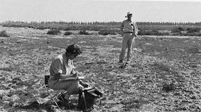
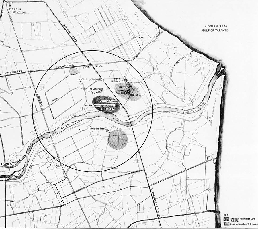
Operating the proton magnetometer with the capable assistance of Dino Gabrielli of the Lerici Foundation, Miss Ralph roved far and wide across the plain, from the Pollinara area in the west to the Casa Bianca area near the sea. The first profiles, each based on a series of readings along a straight line, were made with the intention of finding the total length of the late Roman wall which had been discovered in 1960 and partially traced in 1960 and 1961. It was followed for a distance of about eleven hundred meters without finding clear indications of either end. Numerous anomalies in readings, indicative of buried walls, rubble, and other archaeological material, were found in the Casa Bianca area and the Parco del Cavallo (where the archaic sculptural fragments had been found in a Roman structure). Profiles along both banks of the Crati produced no anomalies, suggesting that the Crati had flowed here even in antiquity. South of the Crati among many anomalies were several caused by an enormous mass of archaic sherds at a depth of four and a half to six and a half meters. In each area where an anomaly in readings was encountered, its position was marked by a stake so that future stratigraphic drilling could determine more accurately the cause of the anomaly.
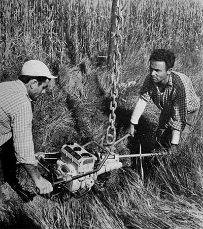
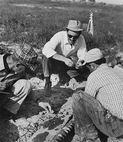
The second phase of operation was the above-mentioned testing of anomalies by boring. The aim of this work was to extract a continuous soil sample from the surface down to virgin soil below the archaeological layer, in the form of a cylinder or in the twists of a spiral auger. The archaeological material, consisting of fragments of pottery, bits of plaster, roof tile, brick, wood, bone, and metal, was picked or washed out of the soil sample, then bagged and tagged with an indication of depth, bore number, and date. It was thus possible to reconstruct accurately the stratigraphy of each bore, the thickness and depth of the Roman, Hellenistic, Attic, and Sybaritic layers. When obstacles such as walls were encountered, the depth was recorded and the drill displaced a short distance to bore anew. Without the boring, our information derived from the geophysical instruments told us little, except by inference. But the actual objects recovered from the bores allowed us to understand the meaning of the anomalous readings and to make further inferences.
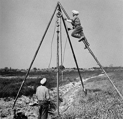
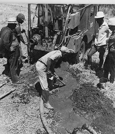
Used in the drilling operations were two types of equipment. A motor-driven helical auger was screwed into the ground, then removed by means of a light tripod and chain hoist. More rapid in operation, but less accurate for determining stratigraphy, was Jeep-mounted wash-boring equipment employing a rotating bit and circulating water to remove cuttings from the bore hole.
A total of over four hundred borings were made during the campaign, most of them with the purpose of checking the anomalies. It was found that strong anomalies were generally caused by burial walls, rubble and other debris of habitation, represented in the borings by solid obstacles which the drill could not pass through and by masses of brick, tile, rock, and plaster and concentrated potsherds in the bore samples.
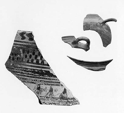
From most of the bores came fragments of pottery, and it was largely by means of these that we were able to plot the areas intensively occupied by the Romans, the Thurians, and the Sybarites. The archaic pottery of Sybaris, predominantly of East Greek origin or imitation, but including occasional fragments of accurately datable Corinthian ware, was found in several areas, notable Casa Bianca, Parco del Cavallo, Latughella, and south of the river in the Ministalla area. Sterile bores along the banks of the Crati confirmed the absence of anomalies in magnetometer readings.
 The final phase of operation was the digging of enormous test pits in order to check the validity of geophysical and drill findings. We hoped to supplement our anomalies and bags of small fragments by bringing to light actual structures and basketfuls of artifacts. As the conventional hand-digging of a test pit to a depth of seven or eight meters would entail the costly and time-consuming work of sheathing the sides of the pit with heavy planks and operating pumps for long periods , it was decided to dig rapidly with a large mechanical excavator. The machine, consisting of a cab mounted on caterpillar treads, had a long boom and a bucket or scoop suspended from wire cables. With this equipment the sterile overburden could be removed in a day, and walls partially cleared during the next day or two. Then would follow a judicious combination of scooping and hand-digging down to virgin soil. Vertical scarps were made by hand so that accurate stratigraphic studies could be made.
The first excavation, Test Pit A, was made in the Casa Bianca area on both sides of the famous long wall. It turned out to be a stone and concrete retaining wall, faced only on the south side and probably constructed in late Roman times. Of undetermined original height, the present remains had a height of over three meters, the top lying slightly more than a meter below the surface. As we dug deeper, we found that it had been constructed on the four remaining courses of a massive Greek wall over two meters thick and preserved to three courses of great square blocks measuring half a meter on a side surmounted by a fourth course (on the north face) of dressed rectangular blocks measuring half a meter by one or one and a half meters. The base of the Greek wall lay almost five and a half meters below the surface. Since the base lay on, not in, the stratum containing sherds of Sybaris, it seems likely that this Greek wall was built by the Thurians.
From Test Pit A, with the water level kept down by continuously operating pumps, came quantities of archaeological material, largely from Thurii, but the lowest part, from about five to six and a half meters below the surface, produced an abundance of Ionian pottery of the early sixth century and a small amount of Early Corinthian ware of the seventh century B.C.
Test Pit B was dug at the easterly end of the wall where other small walls joined it, as was already suggested by proton magnetometer anomalies.

As time was running short and work in Test Pit B was hampered by much Roman debris, attention was turned to Test Pit C, which had already been started a short distance north of A. Here we discovered the same stratigraphy as in A, with a small wall in the Thurian layer beneath which occurred sixth century pottery.
A final test pit, D, was dug in the Parco del Cavallo, where a highly magnetic anomaly had appeared, the opposite of the usually low magnetism indicated by walls. This proved to be caused by a Roman wall made in “opus reticulatum” and bricks with high magnetism, lying on a base of concrete originally faced with marble.
Summing up the results of this unusual campaign, we point first to the experimentation accomplished in methods of archaeological prospecting. The capabilities of several geophysical instruments and two types of boring equipment were demonstrated. The operation of all of these devices is relatively simple, but the interpretation of results may be quite misleading without a complete understanding of what happens under varying conditions of soil and constructions. In this season our experiments, checked by boring and excavation, taught us a great deal about this delicate matter of interpretation.
The use in succession of geophysical detector, drill, and excavator was shown to be an efficient and rapid combination of procedures for archaeological prospecting, particularly well suited for use on the plain of Sybaris.
Substantial progress in the delimiting of the archaeological zone of Sybaris and Thurii was made, and points for future excavation were plotted on the map where anomalies and bore-samples indicated deep-lying structures and archaic pottery. Vast areas of the plain were speedily eliminated as a result of negative evidence from magnetometer readings and bores. It is certain, however, that another season of prospecting will be necessary before we finally yield to the temptation of a large-scale excavation.