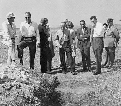
During the last quarter of 1961 an important and extraordinary archaeological survey was carried out in Italy. Its importance lies in the fact that for the first time new scientific instruments were used in a survey by an international group composed of representatives of the University Museum in Philadelphia and the Milan Engineering School. These new instruments are a product of revolutionary developments in atomic and electronic research which are so characteristic of our generation. The results obtained surpassed our most optimistic expectation and they demonstrated not only the steady progress in technical surveys but also the extraordinary efficiency of international cooperation in this field.
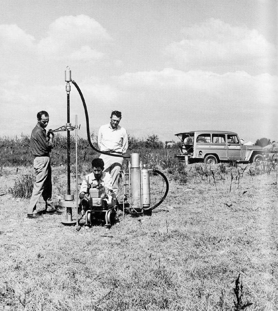
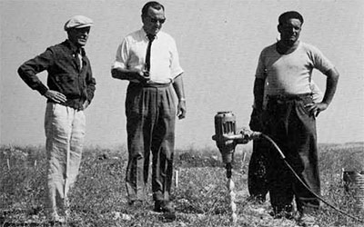
The team of the Milan Engineering School contributed to the campaign its survey equipment, including two typed of potentiometer with electronic volt meter, one electric boring drill, the photographic drill, and the periscope utilized for the exploration of Etruscan tombs. All these instruments were designed by the laboratory of the Lerici Foundation in the Milan Engineering School. The University Museum contributed the proton-magnetometer, a small German-built resistance apparatus, a seismic instrument, and a drill which is said to have been designed for probing the surface of the moon. Members of the joint expedition were Froelich Rainey, James Delmege, Richard Linington, all of the University Museum; and Carlo M. Lerici, Lucia Vanoni, and Franco Brancaleoni, of the Milan Engineering School and the Lerici Foundation. Experiments with the instruments for underground exploration were carried out in various archaeological areas, that is, in the Etruscan area north of Rome, and in Calabria in the south of Italy. The soil conditions and the purposes of the research differed in each area and thus gave greater value to the results obtained.
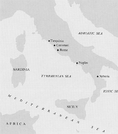
The ruins of the ancient city of Sybaris lie somewhere on the plain of Sybaris beneath some seven meters of alluvial soil formed by the deposits accumulated in more than twenty-five centuries by the rivers Crati and Coscile. The present coast at Sybaris now extends at least one kilometer farther out into the Ionian Sea than in the age of the city and the bed of the river Crati has been raised due to the recent works of land reclamation in that area, so that excavations all over this area made very difficult by the high level of the ground waters and the consequent need of drainage during excavation.
Sybaris is the almost legendary Greek city which was destroyed by the Crotoni in the sixth century B.C. Because of its fabeled luxury we still use the term “sybaritic,” reflecting the statement of Herodotus of the fifth century B.C. “From Italy came Smindyrides, the son of Hippocrates of Sybaris, who of all men on earth reached the highest point of luxury.”For at least a century, differs have searched for the ruins somewhere along the banks of the Crati.
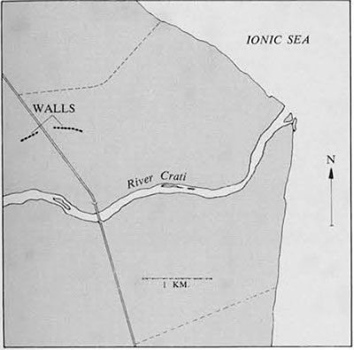
In the spring of 1961 the Lerici Foundation carried out a short experimental campaign on this plain utilizing the electronic instrument known as a potentiometer. With this instrument engineers of the Foundation discovered a buried wall which they were able to trace for about one hundred fifty meters. Superficial excavations tested the precise location of the wall as determined by the instrument. Other underground features were found at this time. It was impossible to establish their real dimension by extensive excavations because of the high level of underground waters. In any case, the principle of underground exploration by new electronic instruments was established by the Lerici Foundation in this preliminary campaign. Then, in October 1961, the combined crews of the two institutions began a second campaign on the plain of Sybaris with new instruments for such exploration. The most successful of these instruments was the proton-magnetometer, developed in Oxford specifically for archaeological uses. It is one of those technical applications growing out of our increasing knowledge 0f atomic physics which makes it possible to detect very slight changes in the magnetic field in the soil. At Sybaris it so happens that the ground, being volcanic, is magnetic, while the stone features sought underground are of limestone, and thus non-magnetic. By measuring abrupt changes in the magnetic intensity in the earth we were able to locate very quickly and easily the position of the buried wall and to trace it for nearly eight hundred meters across the plain. Excavations established the locations determined by the instruments and thus the crew, in a matter of a few days, was able to trace underground an archaeological feature for several hundred meters, a thing which would be impossible with the normal techniques of archaeology.
The function and significance of this long wall at Sybaris remains a mystery. Utilizing heavy excavation equipment, we were able to reach a depth of four meters along the wall in at least one section; but this did not reach the base of the wall and we are still uncertain as to its use or its significance. The difficulty of deep excavation here is due to the presence of ground waters along the Crati river, which made pumping necessary before deep level excavations could be carried out. In any case, we know that the upper part of the wall is of Roman age. How old the lower part may be we still do not know. Is it a harbor wall; a retaining wall for the Crati river; or the base of an aqueduct; and what connection, if any, does it have with ancient Sybaris od the sixth century before Christ? These are urgent questions which remain to be solved in the new campaign to be organized in 1962.
In addition to the long wall at Sybaris, instruments picked up indications of other complicated structures underground probably representing buildings, temples, or other stone structures different from the long wall. None of these could be excavated in the time at our disposal and remain for another campaign. The essential thing is that these new electronic instruments make possible a kind of archaeology hitherto unknown. They increase the scope of archaeological survey and make it possible to locate such a ruined city at Sybaris deeply buried on an alluvial plain where there are no indications of archaeological features on the surface.
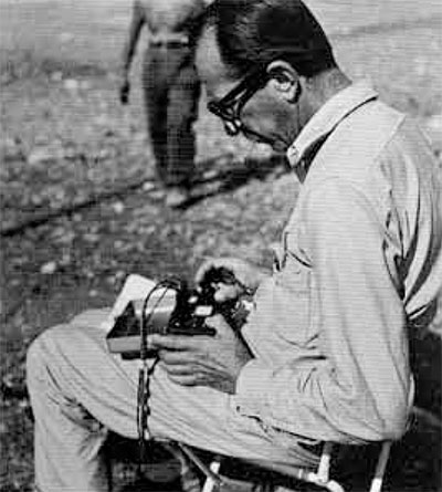
In the famous cemetery of the painted tombs at Tarquinia, the Lerici Foundation located more than thirty painted and several hundred unpainted tombs during the years from 1956 to 1961. These discoveries were made exclusively by the potentiometric method based upon the measurement of the soil resistivity–electrical soundings with instruments designed by the Lerici Foundation. Since a large part of this cemetery has not yet been explored and there are hundreds of tombs yet to be discovered, the combined expedition had the opportunity of experimenting here with the proton-magnetometer, the seismic equipment, and the small portable resistance apparatus. Our objective here in 1961 was to compare various methods of underground exploration at a well-known site. Conditions were ideal for our kind of electronic underground exploration. Here the soil is predominantly marine limestone, and the tombs are cut as chambers into this compact layer of limestone at depths varying from two to six meters below the surface. Ancient archaic tombs appear as low mounds on the surface of the ground in the cemetery, but the later Etruscan tombs are not recognizable from the surface. Entrances to the tombs were cut as steep ramps, trench-like down to the chamber of the tomb. Of course these entrances are also invisible on the surface since they are completely filled with earth and leveled by the action of the winds and centuries of plowing. It is these sloping entrances which are located by the Lerici Foundation engineers utilizing electrical resistance equipment. Electrical anomalies are caused by the cavities of the entrance passages which are now filled with earth. In other words, the electrical resistance or conductance of the earth-filled entrances contrasts with that of the surrounding sub-strata. Once the entrance is located then it is a simple matter to find the tomb itself.
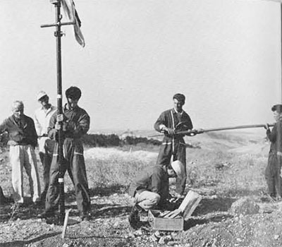

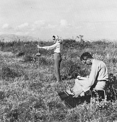
In September of 1961 our combined crews began work at Tarquinia by comparing three different methods of underground exploration–electrical, seismic, and magnetic. Our most important discovery was that the proton-magnetometer, measuring slight changes in the magnetic field, could locate the tombs themselves when a series of magnetic readings were taken on a grid pattern over a section of the cemetery. Magnetic recordings were made at one-meter intervals. A grid measuring 50 x 25 meters (1250 individual measurements) could be covered in less than four hours. Magnetic contour maps of these grids were charted and from these charts we could locate precisely the ancient Etruscan tombs. Then, with the Lerici Foundation drilling apparatus, we put down holes into the chamber of the tomb and inserted the periscope to see what the tombs contained. All of this was done without any excavation whatever. Not more than three or four tombs out of a hundred are decorated with wall painting. Almost all have been looted in antiquity or in more modern times. Thus with these new methods we can eliminate much tedious excavation and much time. With the proton-magnetometer, the location and excavation of tombs can be extraordinarily rapid and such methods make possible the exploration of large areas in a reasonably short time and thus preserve for the future those archaeological features which are most important. On an average, about one hundred magnetic readings or recordings can be made every fifteen minutes.
After a few weeks of this kind of experimentation, it became obvious that the proton-magnetometer was much more efficient in time and labor than the earlier methods of electronic survey. With this method, under normal operating conditions, we could locate and explore five or six Etruscan tombs in one day.
The cemetery of Bufolareccia at Cerveteri, unlike the Etruscan cemetery at Tarquinia, lies in a volcanic sedimentary ground known as tufa. Here too, the tomb features consist mainly of chamber tombs dug in the tufa to a depth varying from one and a half to five meters below the surface. Like those at Tarquinia, there is usually an invisible entrance trench. Considering the volcanic nature of this deposit, the fact that the chambers are smaller than those at Tarquinia, and that a great number of the tombs are filled with earth, water, or mud, it was very doubtful whether the proton-magnetometer could discover them. The Lerici Foundation, using the electrical sounding method, in the years from 1956 to 1961 had located about six hundred tombs in the area at Cerveteri. Our problem was to determine whether the proton-magnetometer would also operate on a site of this nature.

Again at this site, magnetic readings were taken over a rectangular area some fifty meters by fifty meters, with readings made at one-meter intervals. As at Tarquinia, a magnetic contour map was made utilizing these recordings on a grid pattern. When the contour map was completed it was apparent just where the Etruscan tombs lay, even though some of them were at considerable depth. The Lerici drill and periscope made it possible to explore the tombs without excavation. At Cerveteri, unlike Tarquinia, many of the tombs still contained pottery and other artifacts of great value, and some of the tombs found at Cerveteri by this method in 1961 were rich in Etruscan objects.
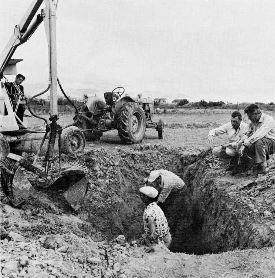
One of the problems in this kind of underground exploration with electronic and atomic instruments is to prove or test the anomalies discovered by such instruments. The Lerici Foundation staff has been using an auger drill powered by an electric motor to penetrate the subsoil in search of tombs or other features. In America, the Houston Tool Company of California had developed a high-speed drill said to be devised for moon probes, which actually is now utilized for various geological soundings and for geophysical prospecting. We thought that it would be ideal for archaeological probes to determine features located by our instruments. It is a light, transportable instrument, which drills a small hole and preserves the cuttings in a plastic container to indicate the strata penetrated by the drill. It is somewhat fragile, but does drill rapidly, and we have demonstrated that it is a very useful tool in archaeology, particularly to probe for the features discovered by these instruments.
The results of this international experiment in underground exploration provide a document of great scientific interest. The Lerici Foundation is now furnishing its survey teams with the proton-magnetometer to determine definitely the limits and possibilities of this method in the various sites in Italy.
The Milan Engineering School is very grateful to the University Museum of the University of Pennsylvania for the assistance given to this kind of technical experiment, and it wishes to have the opportunity in the future to develop this kind of research in Italy and elsewhere with the efficient cooperation of the experts from the University of Pennsylvania.