Once before, in the years 1905-1911, the University Museum conducted a series of excavations in Nubia on the occasion of the heightening of the dam at Aswan. The direction of the expedition was in the capable hands of the late Dr. David Randall-MacIver and of Leonard (later Sir Leonard) Woolley, who subsequently went on to lead the excavations at Ur of the Chaldees as a joint project of the University Museum and the British Museum. The handsome and informative volumes of the Eckley B. Coxe, Jr. Expedition to Nubia are the permanent record of Randall-MacIver’s and Woolley’s labors, which enriched the collections of the museum and make it the finest in this country in Nubian archaeology. The records of their excavations in the New Kingdom necropolis at Aniba were placed at the disposal of Professor Georg Steindorff for inclusion in the publication of his subsequent research at this site.
In 1961 the University Museum, this time in association with the Peabody Museum of Yale University, initiated a second series of excavations in view of the construction fo a new and much larger dam which, when it is finished, will place all the archaeological sites under water. The staff consisted of the author as director, Nicholas B. Millet of the American Research Center in Cairo as assistant director, James Delmege of Montreal and Philadelphia as photographer, Anthony B. Casendino and Jean Jacquet as architects, Edward L.B. Terrace of the Museum of Fine Arts of Boston and Mme. Helen Jacquet-Gordon as archaeological assistants, and Maher Saleeb as representative of the Antiquities Service. The expenses of the undertaking were borne in equal shares by the University Museum, through the Coxe Fund, and the Peabody Museum, through a grant made to it for this purpose by the Bollingen Foundation of New York (established by Mr. Paul Mellon). Through the cooperation of Dr. Hanns Stock of the Deutsches Archaologisches Institut of Cairo, the expedition used the German Institute’s boat and equipment. Dr. George Hughes of Chicago House, Luxor, graciously aided at many stages of the work, and through the cooperation of the Italian and Egyptian Fullbright commissions, we were able to have the valuable services of Mr. Casendino as architect. Among the many friends who aided us it is difficult to single out a few names without omitting others. Particularly we are indebted to H.E. Dr. Tharwat Okasha, Minister of Culture, Dr. Anwar Shukry, Director of the Antiquities Service, the American Ambassador and Mrs. Reinhardt, Mr. John Jermain Slocum, Cultural Officer at our Embassy, Herr Thiele of Hochtief A.G. (Aswan), and Mr. John Goelet of New York.
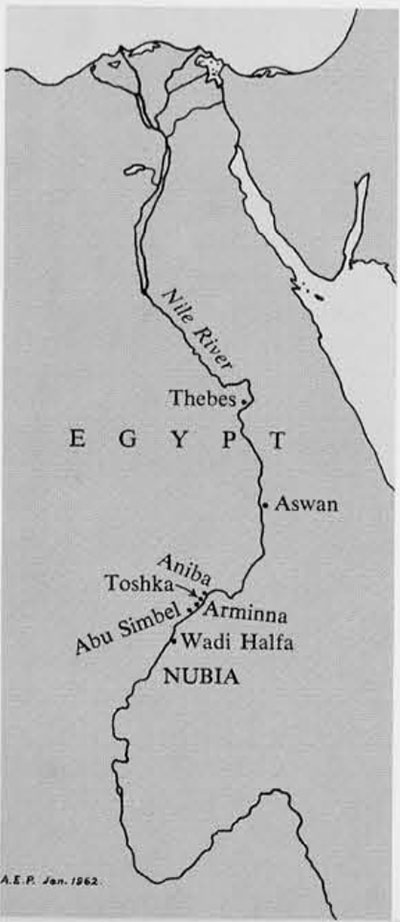
For our excavations we were assigned an area of about twenty miles along both banks of the river, beginning at a point north of Abu Simbel and extending northward to a line south of Aniba. Our concession comprises the adjacent districts of Toshkal in the north and Arminna in the south. The reasons for our interest in this area are several. In our survey for prospective sites in 1960 Dr. Rainey and I noted that the promising sites in the northern third of Nubia were already deep under water as a result of the construction of the existing dam. The middle third included the areas where Randall-MacIver and Woolley had excavated, and we did not wish to duplicate their work. The southern third, however, held promise of many places of interest to us; the only difficulty lay in selecting among many candidates.
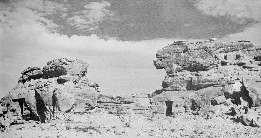
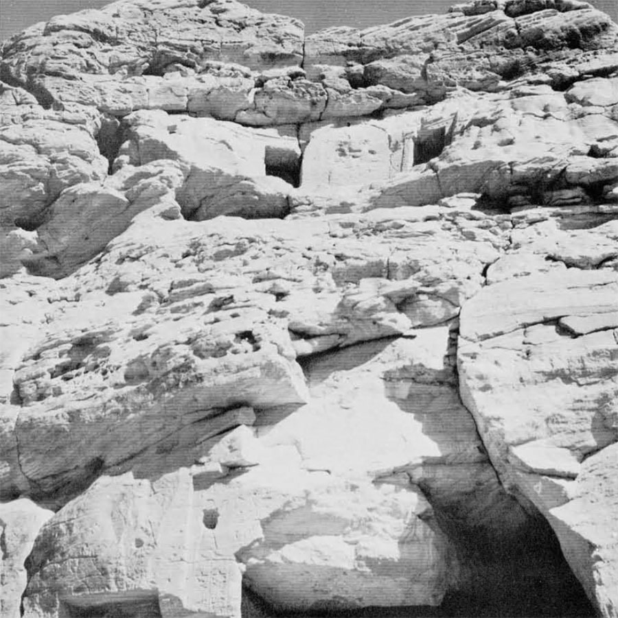
Toshka and Arminna seemed a logical solution. On the west bank Junker and later Emery had worked on a large cemetery of the C-group phase of Nubian archaeology, a period corresponding to the Middle Kingdom in Egypt (about 2000-1750 B.C.). Here also in the Old and Middle Kingdoms was the river terminus for a route to the diorite, amethyst, and carnelian quarries in the waterless desert. The discovery of these quarries and their inscriptions in the years before the Second War was a major event in Egyptology. On the opposite side of the river at Toshka East there were three tombs cut in an imposing rock formation which had never been systematically studied or excavated. Rock texts near this formation indicated that the place must have had special significance.
The problems raised by salvage excavations are indeed vexing. In common with the other expeditions to Nubia which have recently been organized we are faced with a most unusual situation. An archaeological expedition is usually organized to excavate a major site of prime potential in an area of the sponsoring institution’s interest, or else to seek out information about early man in areas where our knowledge is woefully inadequate. Given an unrestricted choice of sites in Egypt, one would scarcely select Nubia as rewarding for spectacular finds or for the more important business of filling in gaps in our prehistoric and historical record. The reason for this situation is two-fold. First, because of the building of the present dam and its later heightening, Egyptian Nubia has been the one area in Egypt which has received the benefit of systematic examination through a long series of archaeological surveys and expeditions. Second, the region has always been something of a cultural backwater and border zone; it has been on the periphery and never in the center of the major events in prehistory and history.
These last considerations, however, indicate one of the attractions of the region for research: as a zone between the political centers to the north and south the area exhibits the changes reflected in its domination first from one direction and then from the other, with the ever present pressures from the peoples of the deserts to the east and the west. The diversity characteristic of the area can be illustrated by the languages spoken today and in ancient times. Although the people of Toshka speak Arabic, they speak Nubian among themselves. The first person one is likely to see in landing at Toshka East, however, is a Bishari herdsman of the eastern desert; his native language is neither Arabic nor Nubian but Bishari. The first man one is likely to come upon at Toshka West speaks Kunuzi, the Nubian language of the north near Aswan. He belongs to a group of men who were resettled in Toshka when the waters covered their houses in the north. Now they will be faced with another relocation. Arabic, Nubian, Kunuzi, and Bishari are thus spoken by the people we meet daily. The situation in ancient times was probably not as complex at any one point in time. Yet in our excavations to date we have had to deal with inscriptions in Egyptuan (hieroglyphs), Meroitic (the language of the area in Hellenistic and Roman times), and Coptic, these languages being listed in the order of their time sequence and the frequency of the inscriptions, as well as in Greek.
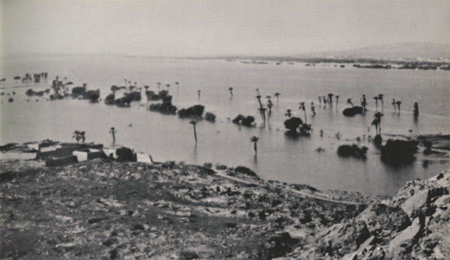
For our first season in this new series of excavations (Pennsylvania’s seventh season counting the 1905-1911 work), we chose to make a compromise between a survey of the area assigned to us and a detailed excavation of some of its features. Considering the extent of previous work in Nubia, we were rewarded by a a season which greatly surpassed our expectations. A brief description of our area may not be out of place at this point. At high water level the western bank of the river within our concession presents the appearance of a sandy beach rising, quite steeply in places, to the desert plateau. Little vegetation is visible for miles at a time. The many craggy sandstone hills and outcroppings in this desert of sand, an extension of the Sahara, are wonderfully strange to behold. Only in the north, at Toshka West, is there a village of any size. The villages in this part of Nubia consist of long bands of rectangular houses facing the river. The houses may form a chain five or six miles long and at times as little as fifty feet in width. In front of the houses is a sandy or rocky strip parallel to the river, and then a thin green strip of cultivation of varying width along the bank which sometimes vanishes completely. On the river’s edge are numerous thorn acacias and occasionally palm groves. In late summer and early winter when the dam at Asway (some 150 miles to the north) is open, the level of the river falls and relatively extensive fields emerge. Submerged temples become visible for this part of the year. Even at high water along the deserted sandy beaches there are occasional points where one can see a group of houses, a cattle-driven water wheel, some few plots of green, and a row of tall tamarisks. The eastern side of our concession at high water consists for most of its distance of a rocky shore without the sand dunes. At the places where cultivation exists on both banks there is always the problem of bringing the boat to land over the submerged fields and through the half covered palms. Often we have to give up the attempt and land miles to the north or south of the point of interest and walk back.
The several sites at which we worked this year exhibited a wide range in time and provided an extraordinary diversity in the finds.
The Rock Tombs at Toshka East
The distinguished Polish archaeologist, Professor Kazimierz Michalowski, visited Toshka East in 1958 and described his visit in a way which vividly recalls our own stay there. “The road led by a narrow path through a dense, partly submerged palm forest, amidst profuse, almost tropical flora. The millions of tiny flies and mosquitoes, buzzing round our heads, completed the sense of being in a humid forest of Central Africa. the forest came to a sudden end in front of broken gebel rocks, with the tropical jungle abruptly changing into an almost moon-like landscape.”
In one of these rock formations just back of the palm grobe three tombs had been cut during the New Kingdom. The modern history of their study, as traced through the Topographical Bibliography and our own researches, is indeed curious. They appear to have been first noted by a French architect and scholar, Jean-Nicholas Huyot, on February 21, 1819. Huyot had studied in the atelier of the painter David and had preceded Champollion to Egypt. In Huyot’s manuscript notes in the Bibliotheque Nationale in Paris are sketches of the plans of the three tombs with observations on certain important features. No attempt was made, however, to copy the texts. Huyot’s trip through Nubia was of prime significance, for his copies of the cartouches of Rameses II at Abu Simbel, were shown to Champollion and provided the latter with an important clue toward the decipherment of the hierogyphic script. Huyot himself was destined to design a structure which is more widely known than Abu Simbel itself, for he was entrusted with the plans for the completion of the Arc de Triomphe in Paris. Through the kindness of M. Henri Seyrig and M. Georges Posener we have been able to consult Huyot’s notes, which, until recently assigned to his authorship by Mme. Vandier, had been filed among the papers of another early traveller and associate of Champollion, Nestor L’Hote.
The second event in the recording of the tombs was an entry made on December 10, 1843, in the notebooks of the German expedition headed by Richard Lepisus. Although plans were not drawn and features previously noted by Huyot were not observed, the entry presents the first attempt to record the texts of the first tomb. It is of particular interest to us in that it records portions no longer preserved and includes points on which we have been able to improve. It omits pieces of the text which had fallen and which we subsequently discovered in the debris lying in front of the tomb.
The third, and until our own work, the last major step was a visit made by Arthur Weigall in 1905 in his capacity of Chief Inspector for the Antiquities Service. At the time of his visit neither the Huyot nor Lepsius notes were available to him. With regard to the text at the entrance to the first tomb Weigall remarked, “more of the inscription could be read in the afternoon when the sun strikes this wall, but the writer visited the place at dawn, and was unable to remain there more than an hour or so.” He provided a sketch plan of the tomb and that adjacent to it on the north (the middle tomb). He also was the first to note and copy a graffito between the second and third tombs. Part of it he translated as “chieftain of Miam, prince (heka) of Nefer,” not realizing that the last part was a proper name and should have been read as “the chieftain of Miam, Heka-nefer.” Had Weigall stayed until the afternoon he would have discovered that Heka-nefer’s name also appeared on the entrance to the south tomb. The plan of the second tomb was supplanted in 1935 by a sketch made by Monneret de Villard, the distinguished Italian scholar of mediaeval Nubia.
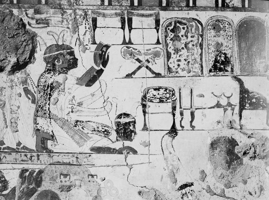
Now, far to the north at Thebes, in Egypt proper, a prince of Miam named Heka-nefer is represented in the tomb of Huy, the Viceroy of Nubia under King Tutankhamun (about 1352-1343 B.C.). Tutankhamun, Huym and Heka-nefer are all represented on the same wall of the tomb, with the latter being shown in a procession of tribute from the southlands. This includes the typical products of ancient Nubia: ivory tusks, leopard hides, gold rings, bags of gold dust, prized stones, Nubian oxen, and even a giraffe. At the end of the procession are manacled Nubian youths, evidently for conscription into the Egyptian army or the king’s service. Of the figures Heka-nefer alone is singled out by name.
Georg Steindorff in 1937 was apparently the first to recognize that the Heka-nefers of the Theban tomb and the Toshka texts copied by Lepsius and Weigall were in fact the same individual. Yet in spite of this evidence it is curious that the tomb at Toshka was not explicitly recognized as that of the same Heka-nefer until our own work this year. Even Steindorff regarded the Toshka chambers as a shrine or cenotaph and not as a tomb. In 1926 the editors of The Tomb of Huy were not aware of the Toshka connections of Heka-nefer. In 1941 in an extensive study of Nubian and Egyptian relations Save-Soderbergh cites the pertinent references but stops short of making the identification. Professor Michalowski in 1958 includes still further references but omits any mention of this prince. And in an excellent article in the UNESCO Courier in 1960 the location of the tomb had been lost sight of so completely that the suggestion was made that it is still to be discovered and probably lies on the other side of the river!
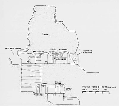
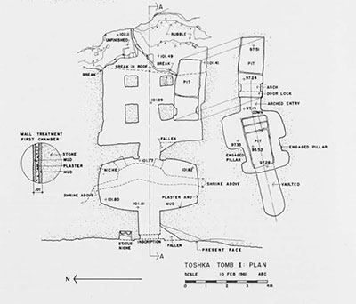
Fascinating as it has been for us to retrace the steps from Huyot’s discovery of the tombs in February of 1819 to our own work in February of 1961, a picture which is probably still incompletely pieced together, we must now turn to a description of the tombs, particularly the southernmost of the three, the tomb of the prince. Casendino’s plan and section, as inked by Der. Scutt, show the features in detail.
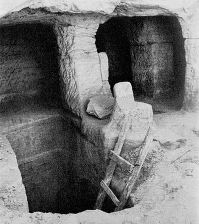
The tomb has many points of interest. To the left of the entrance is a damaged niche which contains the remains of two seated statues carved from the rock. Above the entrance near the top of the rock formation is a shrine in which is a stela with round top and, on either side, a rectangular stela, the whole cut back to form a niche. No traces of texts occur here. The facade in its original state was carved with figures of the prince on either side of the section above the doorway. In the center there was an offering table and probably a representation of the god Osiris. The texts above the entrance continued on the right and left of the doorway. With fallen rock all around and the presence of disconcerting fissures, one seldom felt completely safe while working inside the tomb. Among the fallen blocks we discovered parts of the text which had been in place in 1843 and even larger fragments which must have fallen prior to that date.
The interior of the tomb consists of a rectangular first chamber with markedly curved walls leading into a second chamber with four pillars. The first chamber provided us with a notable surprise, for Terrace and Millet detected some of its original wall paintings obscured by an overlying coat of mud plaster. Slight as these are, they clearly indicate the work of a painter of the Theban school and suggest that he had been commissioned and imported from Thebes by the prince. Indeed, the plan of the tomb with its rectangular first chamber and its second chamber with four pillars may even represent a deliberate attempt to copy the similar plan of the Victory’s tomb at Thebes.

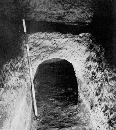
Our interest and attention soon became focused upon the pit in the second chamber, which obviously led to the burial apartments. From the start it was evident that it had been repeatedly plundered. Indeed, in 1819 it had been possible for Huyot to plan the underground chamber of the northernmost of the three tombs, and one assumes that all three burials had been robbed in ancient times. The villagers at Toshka were able to tell us something about the plan of the subterranean portion of the prince’s tomb, even though it was filled with rubble.
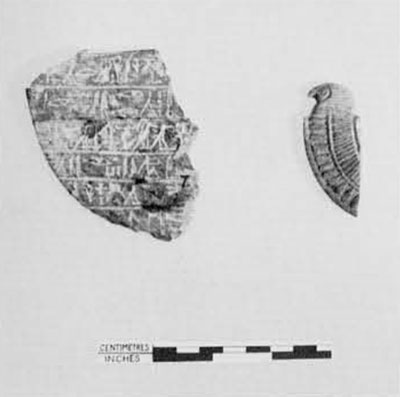
Briefly stated, the pit proved to have an opening at the bottom on the west to a chamber with crude, engaged pillars. The floor of this chamber was cut away, leaving only a ledge, to form another pit, and off this last a small niche was carved either for the burial or for the tomb equipment. It first seemed that nothing was left of the original equipment in the plunderer’s debris. The first objects to come to light were a quantity of potsherds from which Terrace was able to put together the major part of several vessels of New Kingdom type. In the debris of the pit the workmen recovered several shawabtis in varying states of preservation. Of these funerary statuettes one was of faience, the upper half of another of painted limestone, and three of a greyish green stone. The finest two of these last were inscribed with Heka-nefer’s name and chief title, Prince of Miam. In addition to the shawabtis the tomb yielded portions of a soft stone pectoral with floral designs and the heart scarab text, a piece of a stone collar terminal with a falcon’s head, a copper furniture terminal in the shape of a papyrus column capital, and fragments of an alabaster bowl.
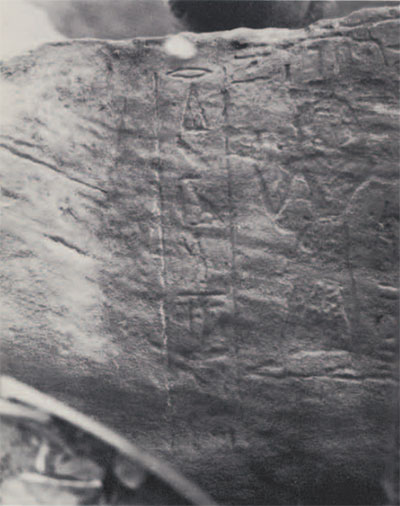
Not only did we locate the graffito of Heka-nefer described by Weigall but we discovered four additional ones at some distance to the south not previously observed. These provided two more titles. His official status is indicated by the title Prince of Miam, the district of Nubia which he ruled and administered. He was also chief river transport officer (hry hnw). Of particular value in assessing his relation to the royal court at Thebes are the other three titles. Foremost is “child of the nursery,” an indication that he had probably been brought up with the royal children at Thebes and there indoctrinated with loyalty to the Egyptian state. Second, he was a “bearer of the folding chair (or perhaps quiver) of the lord of the two lands,” a designation relating to his ceremonial position in the royal service. Third, he is called “king’s sandal” or “king’s sandalmaker,” a title which either stresses his subservience to the ruler or else suggests that Miam was a region in which a leather industry of note flourished.
One of the striking conclusions of our work on Heka-nefer is the contrast apparent between his representation at Thebes, where he is shown as a typical Nubian with dark skin, heavy lips, and southern costume, and the impression made by the tomb at Toshka from which one would surmise that he was an Egyptian official. The latter is copied from the model of the Tehban tombs. The figures of Heka-nefer on the facade and the shawabtis are typically Egyptian and do not betray the fact that he was a Nubian. Only his name, with the meaning “the good chief,” suggests this. Slightly over a hundred years before Heka-nefer’s time, in the reign of Tuthmose III and Hatshepsut, a Prince of Tehkhet named Djehuty-hotpe constructed a tomb some thirteen miles north of Wadi Halfa in the Sudan, not far south of Abu Simbel. In many ways he was an earlier counterpart of Heka-nefer. Not many principalities would have separated the borders of Miam and Tehkhet. Like Heka-nefer after him, the Prince of Tehkhet had the walls of his tomb painted in the tradition of the contemporary Egyptian tombs. There are some indications in the scenes, however, that the Nubian locale was at least indicated. The general impression to be gained from Djehuty-hotpe’s tomb with its hieroglyphic inscriptions is the same: the attempt made to follow the model of the Egyptian tombs at Thebes. The tombs of Heka-nefer at Toshka and Djehuty-hotpe at Debeira are the only painted tombs of the Eighteenth Dynasty found so far in Nubia. Therefore, one particularly regrets that the paintings at Toshka have not survived in better form.
The middle and northern tombs at Toshka were disappointing after the work on Heka-nefer’s tomb. the middle one was of interest architecturally and featured a pit with a long stairway leading to the plundered chamber. In Christian times crosses were incised in the first, pillared hall. The third (northern) tomb had a painted ceiling with geometrical designs and with faint traces of a central band of inscription no longer legible. The names of the owners of these tombs were not recovered, but one may belong to a Prince of Miam named Re-hotpe, whose name and title occur in a graffito south of the tombs, and the other to Re-hotpe’s father, Hatiuy.
The Ledge Shrine of Gebel Agg at Toshka East
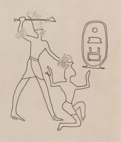
The northernmost point of our concession on the east bank is a sizable hall with two rounded humps known under the local name of Gebel Agg. Surrounding it completely except on the river side is a low, crudely built stone wall of unknown date, doubtful purpose, and questionable use in view of its insignificant height. On the river side a steep drop could have been utilized to render the hill defensible with a minimum of effort. Halfway up the southern slope is a partly natural, partly manmade ledge affording an unparalleled view to the south for some distance on both sides of the river. On the rear wall of the ledge various inscriptions have been carved above a crude man-made bench. The earliest graffito at the site of this lookout is a roughly carved scene with the details painted in red, yellow ochre, and white. A king wearing the white crown of Upper Egypt is represented holding a weapon aloft and about to dispatch a miserable Nubian whom he holds by the hair of his head. The pharaoh thus shown in this representation of a characteristic aspect of Egyptian foreign policy is identified by the cartouche as Sesostris III, the conqueror of Nubia in the Twelfth Dynasty, who was later considered as a deity particularly associated with Egyptian interests in Nubia. Although one might argue that the proportions of the figure and the nature of the weapon suggest a later date, the technique of incising and painting can be cited in favor of dating the scene in the late Middle Kingdom. I am inclined to regard the scene as the earliest of the graffiti at the ledge shrine and in fact the reason for the later texts appearing there. If my interpretation is correct, the ledge is in fact a rustic shrine with Sesostris III as the deus loci.
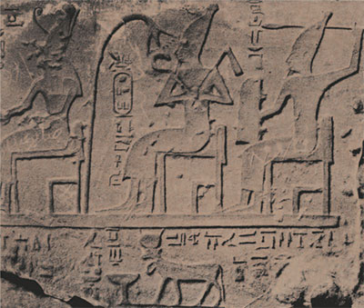
Although the scenes had been previously known, a satisfactory examination of the ledge shrine had never been made. The main scene is four feet long and a foot and a half high. On the right are three seated gods approached form the left by five standing worshippers. The deities are Horus, Lord of Miam, followed by the deified Sesostris III, and lastly the god of pestilence Reshep. Stelae of Reshep have been found in Nubia, but his place of origin was Palestine, whence his cult spread eastward to the Euphrates and northward to Anatolia, as well as southward to Egypt and Nubia. Weigall’s remarks capture some of the interest of the site and the scene. “There is an interest in this shrine which is as rare as it is pleasing, and it is to be hoped that it will be visited by the archaeologist and the scene properly copied. One sees here a native herdsman or farmer offering to an Egyptian and Asiatic war-god and to a deified hero, in a rude rock shrine on a hill-top; one sees his hunter son bringing as a sacrifice the gazelle which he has shot in the desert; and one reads of the herdsman of the sacred cattle, and the watchman whose care it was to collect the horns which formed part of the Nubian tribute. To this day one may still see the gazelles wandering over the rocks; and with this shrine before one, the imagination is able to recreate the pastoral scenes in which Nebsy and his sons lived.”

Below the main text, described above in Weigall’s words, is a scene of a worshipper with the label “made by the henchman Neb-enteru for his lord Kha-ku-re (Sessostris III).”
On repeated visits to the ledge for tracing the scenes and photographing them, tasks made difficult by the high winds and varying lights, we frequently chanced upon fragments of a sandstone stela and a sandstone offering basin on the slope of the hill below the ledge. The pieces of the basin gradually provided us with more and more of its text. It was inscribed for an individual named Messuwy and bore a cartouche which seems to have the traces of the prenomen of Seti I, Menmaat-Re. The writing of the stela also bears a cartouche, but the signs are too faint to be read with certainty; perhaps the king represented wearing the white crown is Sesostris III.
In front of the ledge at a slightly lower level was a thick deposit of pottery of the so-called pangrave types, red polished bowls with shiny black interior and a narrow black band on the top on the exterior, a coarser ware with incised designs, and a ware impressed to make it resemble a rough woven fabric. This debris did not belong to a plundered tomb but represented the discarded pottery of the watchman who used the lookout. The fragments of the stela and the offering bowl also came from this vicinity, and I suspect that they had once been set up in the ledge shrine and were then discarded. Further work is necessary to check these speculations.
The Schoolhouse Khor at Toshka East
To the south of the rock tombs is a khor, an old tributary bed into which at high water level the present river backs. On the high ground on the north is a village post office, from which there is a weekly collection of mail in each direction. On the high ground to the south is the village school. On rare occasions, perhaps a few times every hundred years, a major rain storm in the eastern desert causes flash floods to rush through these ancient water courses and wreak havoc with anything in their path. On the high ground to the north there is also a cemetery of the C-group period, the phase of Nubian archaeology corresponding to the Middle Kingdom of Egypt (about 2000-1750 B.C.). It appears to have been thoroughly plundered. We excavated a typical tomb and located others. Although we shall continue to examine the area, it is unlikely that it will reward us with any additional information about the C-group peoples.
On the south side of the khor in a crevice below the schoolhouse Weigall copied a number of rock texts in 1905. It was clear that the visible texts were quite near the ground level and that additional ones might be found by clearing away the sand and rubble. We set the workmen to this task while we were arranging to transport them to the other side of the river. To our delight they uncovered three graffiti of the same Heka-nefer whose tomb they had just completed excavating. The mayor of the village, noting our interest in these scenes and texts, called our attention to a fallen rock on the under side of which a few signs could be made out. Upon clearing away as much sand as we could without endangering our lives, we found that this also was Heka-nefer’s work. The line of inscription, about six feet long, provided us with new titles of the prince, and below it was a representation of the prince, his brother, and one of their boats. To copy and photograph the scene James Delmege had to use mirrors, thereby photographing the reflection.
There were other sites at Toshka East which I have not had space to discuss. To the reader who has followed our account thus far, it may now come as a surprise that we worked here for less than two weeks and that only a small fraction of our finds derive from the work on the east bank. The excavations on the west side of the river were the most rewarding. They will be described in a forthcoming number of Expedition.