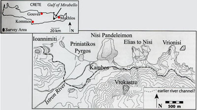
Priniatikos Pyrgos, a coastal settlement in eastern Crete, sits upon a limestone promontory in the center of a broad beach. Its location—at the nexus of cross-island routes and near rich coastal valleys with abundant water—makes its protected anchorage an ideal spot for a trading emporium. Discoveries here in the early 20th century indicated that the site had stratified archaeological deposits ranging from at least the Bronze Age (3rd and 2nd millennium BC) through to the Roman period (1st century BC–5th century AD). This suggests that it may have been the primary harbor along the west-central coast of the Gulf of Mirabello for thousands of years.
In 2002 we initiated the Istron Geoarchaeological Project to explore the Istron River Valley and the region around Priniatikos Pyrgos. Our aim is to understand the nature of this region, its environment, and the role this site played in its cultural development. Given its location and longevity, our research focuses on exploring Priniatikos Pyrgos to see what it might reveal concerning the cultural history of the region and its links with the Aegean over the last five millennia.
Exploring Through Remote Sensing
Initial work involved the use of remote sensing to determine the extent of the harbor settlement. To explore the site’s ancient topography, we drilled cores at intervals near the coast and excavated trenches with a mechanical backhoe. Remote sensing—which works best with shallow subsurface features—indicated probable Greek or Roman architecture extending south away from the coast and east along the coast. In the area known as the Kambos (about 250 m to the east) we recorded massive walls under a modern soccer field. On either side of the field our cores and trenches produced abundant Bronze Age pottery at the depth of these walls. Deeper still, we found Neolithic (4th millennium BC) pottery directly above the water table, suggesting that a large Neolithic coastal settlement lies under the Bronze Age site in the Kambos.

Our remote sensing results also indicated well-preserved architecture, possibly stratified in two phases, in Area G on the western side of Priniatikos Pyrgos. We also found a large, iron-smelting slag heap on the promontory’s west slopes, where furnaces could have utilized the northwest sea winds. In the center of the promontory, Area A, remote sensing also identified possible ceramic kilns or smelting furnaces near the slag heap. Other evidence for pyrotechnical (fire-based) industries at Priniatikos Pyrgos included a possible ceramic kiln that was seen eroding into the sea along the site’s western edge (Kiln 1).
These preliminary results suggest that Priniatikos Pyrgos was probably part of a much larger settlement that included the Kambos and Nisi Pandeleimon areas to the east. This evidence increases the likelihood that this site was the primary harbor in this region of the gulf. Our results also indicate that Priniatikos Pyrgos was a center of craft specialization for both ceramic and, later, iron production. In fact, the settlement’s genesis and longevity may have been related to its proximity and access to resources, such as the iron ore found within the Gulf’s unique geology. Consisting of diorite and granite, the region’s igneous rock is known as granodiorite. Besides providing a source of iron, it also was used to make tools in the past and as a temper to be added to clay during ceramic production. These regional resources for craft production in ceramics, stone, and metal, and its topographical situation, facing prevailing sea winds, provided the genesis for long-term industrial activity on Priniatikos Pyrgos.
Excavating Industrial Activity
After a second small kiln was exposed by wave erosion on the northwestern slopes of the promontory in 2004 (Kiln 2), Metaxia Tsipopoulou and Barbara Hayden initiated a rescue excavation in 2005. Our aim was to reveal the scope of industrial activity in the harbor settlement and to identify how regional resources were utilized to produce goods, such as ceramics and iron, which in turn could be traded throughout Crete and the wider Aegean world.
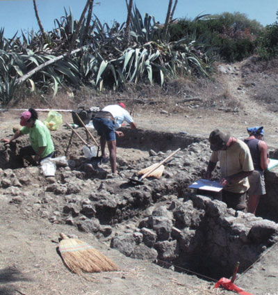
We excavated trenches in three locations: Areas H and G (H1000, G1000) were explored to reveal the two partially exposed ceramic kilns, while Area A (A1000) was investigated to recover the kilns or smelting furnaces identified by our remote sensing. In general we found well-preserved architectural remains and pottery dating from the early 3rd millennium BC through to the Byzantine and Venetian (10th–17th centuries AD) periods.
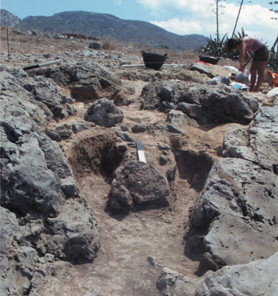
In Area H1000 we exposed a ‘channel’ or flue kiln (1 x 1.5 m) built into a bedrock crevice (Kiln 2). This kiln had a small western firing chamber and two channels made of mud and cobbles, extending east from its firing chamber and separated from each other by a low wall. Stone slabs were often used to bridge these channels; these supported the unfired pottery so that heat and smoke could circulate through the channels and then exit through a hole in the kiln’s dome. Although these slabs were not found in place, we did find two mud surfaces (6-8 cm thick) in the channels, and between them, a layer of burned earth whose west side was exposed to the sea winds and water. This burned soil contained Early and Middle Minoan sherds and animal bone that might have washed into the kiln after its use. The exact chronology of the kiln has not been established, but in terms of shape and size, one close parallel comes from the nearby Minoan harbor town of Mochlos, in the eastern Gulf of Mirabello. The Mochlos kiln belongs to the Late Minoan period (ca. 1750–1550 BC).
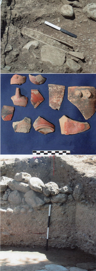
Although trenches H2000 and H3000 (to the east and south) are not yet completely excavated, fragmentary and rather flimsy rubble walls found in H3000 may be evidence of a workshop area. This function is also suggested by abundant worked obsidian, groundstone tools, marine shells, iron slag, mold-made lead rivets, and fragments of bronze and glass found in this trench. Here we also found a few intact Late Minoan cups near and slightly above a long clay water channel. This channel, or drain, has a flat base and four handles and was found on a white-yellow prepared clay surface spread over a layer of beach pebbles. Similar ‘floors’ have been observed in other trenches (see below); associated pottery suggests these belong to the Bronze Age and the Greek periods.
Interestingly, while the cups and water channel are Late Minoan, much of the pottery found in fill overlying H3000 comes from the Early Minoan period. For example, Vasilike Ware predominates in a wide variety of forms. This high-quality, handmade pottery has a mottled surface with shades that vary from orange to red to red-brown to black—colors that were produced by manipulating the kiln’s internal atmosphere from oxydizing to reducing during their firing. This ceramic type is the hallmark of the Early Minoan IIB period and is widely distributed throughout eastern Crete. Among the Vasilike Ware, several clay fabrics were identified, including one containing pieces of the local black-and-white granodiorite. This may indicate that Priniatikos Pyrgos was one of several centers producing Vasilike Ware vases in the mid-3rd millennium BC. Since the distribution of vases with granodiorite temper is archaeologically traceable, in the future we should be able to reconstruct ancient trade routes based on this clay fabric.
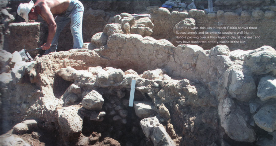
In Area G—30 m south on the lower western slope—we excavated a trench (G1000) around a large kiln eroding out of the steep slope (Kiln 1). This trench’s eastern edge revealed a deep cross-section of the site’s archaeological stratigraphy, showing walls and archaeological layers that document most of the site’s cultural history. The first layer below the surface contained everything from modern garbage to Minoan and historic period (Greek and Ottoman) sherds, bits of iron and bronze artifacts, loom weights, glass, a small greenstone lid, burned clay, and groundstone tools. Below this layer, a harder yellow-brown, claylike sediment (which may derive from mud-brick building material or roofing clay) contained carbon, small pieces of white lime plaster, patches of burned clay, and Minoan pottery. At the base of this layer we found more possible floors—thin layers of beach pebbles and yellow-white clay, although these layers were not continuous across the trench.
Below these ‘floors’ on the south side of the trench, we discovered part of a Minoan green schist paving with a kernos—a circle of small depressions for cult food offerings—incised on one of its stones. On the north side of the trench we recovered burned clay, groundstone tools, stone weights, and a possible potter’s wheel, and in the trench’s eastern profile we found a small clay boat above two worn limestone pavements—the lower of which was at approximately the same level as the green schist paving to the south. These finds again suggest craft activities, including ceramic production related to the large kiln.
In the center of trench G1000, between the pavements, we exposed a large ceramic kiln with three mud-lined channels/ flues, each separated by thin rubble walls, extending west toward the sea. Although erosion has destroyed this kiln’s western firing chamber, the kiln’s long southern exterior wall shows that it measured over 3 m east to west. On its east side, small stones carefully packed over a thick clay platform may identify where the pottery was fired. This type of Minoan kiln dates to the Neopalatial period—the early part of the Late Bronze Age (ca. 1700–1550 BC), and parallels are found at several other Cretan sites (e.g. the large and well-known one at Kommos).
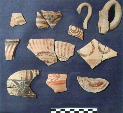
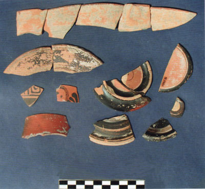
The two kilns uncovered at Priniatikos Pyrgos indicate that it was a pottery production center and coastal distribution point for regional ceramics during the Minoan period. Like other Minoan coastal sites (e.g. Kommos, Gouves, and Mochlos), Priniatikos Pyrgos produced vases for export or as containers to ship regional produce such as wine, honey, or oil. This production continued well into the historic period as indicated by Roman wasters (extremely vitrified ceramic sherds) found at the site. In the future, we hope to use the unique ‘signature’ provided by the granodiorite temper in Priniatikos Pyrgos’s pottery to trace their distribution throughout eastern Crete and beyond and to reconstruct both the prehistoric and historic trade networks.
Historic Period Activity
The 2005 excavations on the promontory also revealed later aspects of the settlement’s history during the Greek, Roman, Byzantine, Venetian, and Ottoman periods. For example, trench G2000 initially exposed a paved path (calderimi) that probably dates to the Ottoman period. Below this walkway we then found the walls (but no floors) of one or more Roman buildings that may have been simple houses. Beneath these, in turn, we discovered a few more fragmentary walls in association with fine Greek pottery from the 6th–4th centuries BC, and at 1.5 m below the surface in the southwest part of the trench we encountered a large north-south rubble-built wall (G2035) associated with a plaster floor and Minoan pottery. Later settlers built over the prehistoric structures of their Bronze Age predecessors—the possible homes of the Minoan craftsmen.
The most interesting and unexpected of these finds were the fine Greek sherds of imported black glazed and red-figure vases that were especially abundant in an ash deposit in the southeast part of the trench. Neither Edith Hall’s earlier excavations nor our own surface surveys had recovered abundant Greek pottery. These Athenian ceramic imports will provide insights concerning economic and historical ties between Crete and the Greek mainland during a critical phase in the development of Greek civilization.
Future Possibilities
Another trench (A1000), located near the center of the promontory, revealed a broad, well-worn limestone pavement which probably formed part of a courtyard or possibly a road. Flanked on its west by older walls, we found potsherds that seem to date the pavement to the Late Roman, or Byzantine, period (ca. 5th–8th centuries AD). Just to the northeast of this trench, the apse of a ruined building is visible on the hill’s crest. Local tradition holds that this was a Christian chapel. Was it, and does the paving in trench A1000 lead to this structure? Only future excavation can say.
In the northwest corner of the trench we found a few small cobble-built circular structures that might be small shaft furnaces for smelting iron. This seems likely given the presence of slag, some of which is fused to the structures’ internal clay lining. Further evidence for metallurgical activity can be seen on the surface to the north and west of trench A1000, waiting to be explored.
Our excavations at Priniatikos Pyrgos have just begun. Over the next few years we will continue to investigate the nature and duration of regional craft production at the site and the use of the local environment and its resources. Edith Hall’s pioneering work in Crete and the Vrokastro Survey provide both the background and framework for this new work. Eventually we should be able to document the harbor settlement’s long history and identify its trade networks across the southern Aegean and how these changed over time.
Hall, Edith H. Excavations in Eastern Crete, Vrokastro. Philadelphia, PA: University of Pennsylvania Museum, 1914.
Hayden, Barbara J. “The Coastal Settlement of Priniatikos Pyrgos: Archaeological Evidence, Topography, and Environment.” In Meletemata II. Aegaeum 20, edited by P. P. Betancourt, V. Karageorghis, R. Laffineur, and W.-D. Niemeier, pp. 352–55. Liége, Belgium: University of Liége, 1999.
Shaw, Joseph W., A. Van de Moortel, Peter M. Day, and V. Kilikoglou. A LM IA Ceramic Kiln in South-Central Crete, Function and Pottery Production. Princeton, NJ: Princeton University Press, 2001.
Soles, Joseph C., and Costas Davaras. Mochlos IA. Period III. Neopalatial Settlement on the Coast: The Artisans’ Quarter and the Farmhouse at Chalinomouri. The Sites. Philadelphia, PA: Institute for Aegean Prehistory, 2003.
Vallianou, Despoina. “The ‘Potters’ Quarter in LM III Gouves.” In TEXNH II. Craftsmen and Craftsmanship in the Aegean Bronze Age. Aegaeum 16, edited by R. Laffineur and P. P. Betancourt, pp. 333–43. Liége, Belgium: University of Liége, 1997.