When the Roman army defeated the allied forces of the Greeks near Corinth in 146 BC, this marked the end of the life of the Greek city. The male citizens were killed and the women, children, and slaves were sold into slavery. The city itself was partially destroyed and it ceased to exist as a political entity. Over a century later, in 44 BC, Julius Caesar established the Roman colony of Colonia Laus Iulia Corinthiensis on the location of the former Greek city.
Researching the transformation of Corinth from a Greek city into a Roman colony and tracing the physical manifestations of that change are at the heart of the Corinth Computer Project. During ten summer seasons of fieldwork (1988-1997). we have had several objectives: to study the city planning during the Roman period; to evaluate the accuracy of the Roman surveyor, the agrimensor. and his surveying instrument, the groma; and to create a new, highly accurate, computer-generated map of the ancient city which can discriminate between—and thereby allow study of—the successive phases of the city’s development.
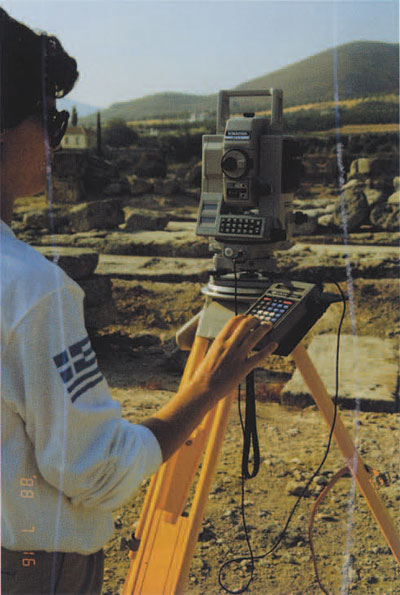
Working with undergraduate and graduate students from the University of Pennsylvania. we set out to uncover the detailed planning of the Roman colony using an electronic total station, Auto-CAD, and engineering and mapping programs. Our work was carried out under the auspices of the American School of Classical Studies, Corinth Excavations (Dr. Charles K. Williams II, Director). By 1997 we had accurately surveyed every roadway and above-ground monument in the city and had created the framework for a new map of Roman Corinth. Our work continued during each academic year in the Mediterranean Section of the University of Pennsylvania Museum, where, assisted by numerous students, we digitized 16 1:2000-scale topographical maps representing the 35 square kilometers surrounding the ancient city, and created actual-state drawings of all the excavated buildings and monuments of the city.
Since 1988 the project has utilized, in addition to the computerized surveying, a number of modern scientific methods, including digital cartography, GIS, and remote sensing. Through the combination of these techniques it has been possible literally to discover the original plans that the Roman surveyors brought with them for the design of the Caesarian colony of Corinth, its urban as well as its rural organization.
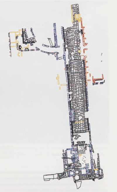
From our electronic total station survey, we completed a highly accurate map of the ancient city that included the location and orientation of roads, build¬ings, structures, walls, and monuments. We were then able to add to this base map features identified from low-level and high-level aerial photographs, low-level balloon photographs, and satellite images. Each of these sources of data needed to be geo-rectified to eliminate distortion and to make the photographs as accurate as possible with respect to the maps.
The scope of the project has grown enormously since 1988. Our immediate objective then was to study the planning of the roads and buildings in and around the forum at the center of the Roman colony. We now have in place a computerized map, created by means of 66 1:500o rectified topographical maps together with aerial photographs and satellite images, of most of the ancient Corinthia, an area that is close to 750 square kilometers.
A totally unexpected result of our study of the Corinthia was the discovery of physical vestiges of a second Roman colony, Colonia lulia Flavia Augusta Corinthiensis, founded by the Emperor Vespasian in the AD 70s. Previously, this colony was known only from numismatic and epigraphi¬cal evidence and had been thought to have been of titular importance only, but the results of our fieldwork have shown that the colony had a physi¬cal presence in the urban and rural landscape.
David Gilman Romano
Senior Research Scientist, Mediterranean Section Director, Corinth Computer Project