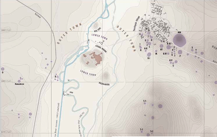
Gordion, in central Turkey, is the largest and longest-running of the Penn Museum’s many excavation projects. An ancient site of great historical significance, Gordion was occupied for 5,000 years from the Early Bronze Age (ca. 3000 BCE) through to modern times. Its high point was in the Iron Age (the early first millennium BCE) when it was the capital of the kingdom of Phrygia. Penn’s Gordion project began in 1950 and has run continuously to the present day. In six decades of research there have already been two major series of excavations, 1950–1973, directed by Rodney Young, and 1988–2006, directed by Mary Voigt. A third series, begun in the summer of 2013, is being directed by C. Brian Rose. As a result of this enormous excavation drive, a large part of the Citadel Mound has been investigated together with around 40 elite burial mounds, as well as select areas of the city’s suburbs, outer fortifications, and lower class cemeteries.
The spatial relationships inherent in archaeological evidence—structures, deposits, features, artifacts, the remains of the dead—are fundamental to analysis and interpretation. Accurate mapping is therefore essential for good archaeological practice. In order to properly represent spatial layouts belonging to one specific time period and sequences of layouts through time, the remains must first be linked to a reliable system of planimetric (horizontal) and altimetric (vertical) coordinates. The precision with which coordinates are recorded will depend on the mapping technology available at the time, and on the requirements of the post-recording analyses involved.
Archaeological excavation is by its nature a destructive process, because to investigate earlier underlying material one must first remove the later overlying evidence. It is therefore critical that the recording is accurately completed as the work proceeds. Unlike non-destructive types of archaeological investigation (e.g. field survey or geophysical prospection), it will not be possible to check the majority of the actual remains later on, because they will no longer exist, at least not in situ.
Of course, in the real world not everything goes according to plan. Mapping is a complex task and it is not unusual for mistakes to be made which can remain unnoticed for years. Inaccuracies, however, are unforgiving, and will ultimately emerge to cause problems when attempting to integrate the spatial data for research purposes. These problems are magnified as the scale and complexity of archaeological datasets increase, and can become serious obstacles to comprehension and presentation, inhibiting the pace and quality of analysis and publication.
Unfortunately, the excavated remains from Gordion were never accurately referenced to a reliable site-wide coordinate system. The planimetric and altimetric referencing was seriously compromised in the very first excavation season in 1950 through a series of surveying and tracing errors. Most of the mapping work in successive seasons was based on this initial, faulty survey, and, over time, errors spread and inaccuracy became endemic to the Gordion mapping corpus. Although it became apparent years later that there was a problem with the referencing, the issues were never fully understood and the attempted remedies proved not only unsuccessful but also contributed further complexities to the problem (for a detailed account, see Pizzorno and Darbyshire 2012).
By 2008, when we initiated the Digital Gordion Mapping Project, most of the original maps and plans—showing excavation trenches, architecture, and other remains—could not be reliably integrated and the real locations and spatial relationships of the evidence were only approximately known. Of course, the Gordion excavation project has, in the past, continued to publish a limited corpus of maps and plans, which over six decades has served the interim purpose of conveying the site’s spatial attributes. But it has not been possible to produce the kinds of spatial representations that are essential for the comprehensive, detailed, and definitive analyses that still need to be completed for Gordion, such as accurate site maps showing all the excavated areas, accurate plans of remains from a single period, phase plans showing sequences of remains through time, or reconstructions of the architecture and spatial layouts.
To resolve this situation we needed to unify the Gordion mapping data by accurately referencing them to a single, reliable system of planimetric and altimetric coordinates. Utilizing a custom-built Geographic Information System (GIS), we began the process of referencing the cartography to a worldstandard coordinate system, Universal Transverse Mercator (UTM).
The first step was to scan over 2,000 maps and plans, the core of Gordion’s mapping corpus, so that they could be imported into the GIS.
Once the drawings were imported, we could begin the arduous task of referencing them (i.e. assigning them accurate coordinates). In the case of those remains still in situ on site, obtaining accurate coordinates was simply a matter of resurveying them, which we accomplished in 2008, 2010, and 2013. However, the bulk of the mapped archaeological evidence and excavation trenches at Gordion no longer existed and hence, for these, resurvey was not an option.
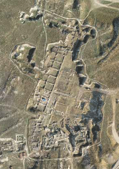
To deal with this situation we first created a system of “snapshots,” using aerial photographs and satellite images taken at different times over the last 60 years. These images, once they had been referenced in the GIS, provided spatial cues for accurately aligning the plans of long-gone trenches and excavated structures included in the original photographs. As a basis for the referencing we initially used a QuickBird satellite image (rectified in partnership with NASA). However, in 2010 we dramatically enhanced the accuracy of the system by using a series of balloon photographs taken that year, which we referenced using thousands of control points surveyed on-site using a high precision dGPS (differential Global Positioning System) unit.
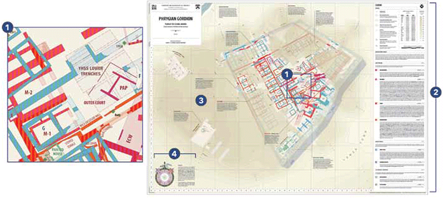
We then integrated the still unreferenced maps and plans by looking for correspondences between them and the data already in the GIS, namely architectural elements, trench outlines, old survey markers, or topographical features. With the original plans referenced, we could then move on to vectorizing their contents. This involves tracing the features depicted in each plan, in order to transform them into discrete elements which can be easily recombined and manipulated however we require.
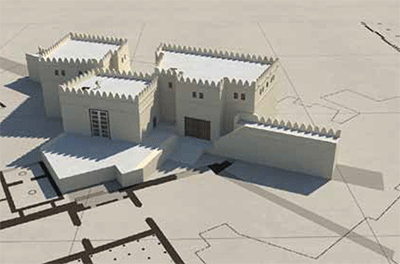
Since the GIS integrates all the data, we can select whichever components we wish in order to create an endless variety of new maps and plans, tailored according to the research issues in hand. At the same time, the power conferred by digital technology gives us enormous creative flexibility in graphic design, allowing us to present Gordion’s spatial data in innovative and attractive formats. To highlight these points, the accompanying illustrations show some recent examples of our work, in the form of maps, plans, and three-dimensional reconstructions. All of these creations require not only accurate digital data but also detailed archaeological research to resolve the many archaeological issues and problems that inevitably emerge, and so the process of constructing them is always a catalyst for new research.
Under our supervision, the bulk of the GIS work has been carried out by Penn graduate and undergraduate students, funded by two grants from the University Research Foundation in 2009–2010 and 2012–2013. This has provided the students with an opportunity to acquire cutting-edge skills as part of a comprehensive research experience that trains them to solve problems associated with a real and complex dataset.
For Further Reading
Darbyshire, Gareth, and Gabriel H. Pizzorno. “Building Digital Gordion: Coping with the Past in the 21st Century.” Expedition 51.2 (2009):23-30.
Pizzorno, Gabriel H., and Gareth Darbyshire. “Mapping Gordion.” In The Archaeology of Phrygian Gordion, Royal City of Midas, edited by C. Brian Rose, pp.23-38.
Philadelphia: University of Pennsylvania Museum, 2012.