Not many of us are lucky enough to be able to conduct “expeditions” from our own doorstep—although I have a friend who upset his wife badly by spending several weeks excavating, not unproductively, under the fireplace in the living room of their mediaeval farmhouse. My brother and I, however, were among the fortunate few, and for nearly ten years in the 1930’s used to walk out for fresh air, exercise and what we could find the mile or so from our home at North Ferriby in East Yorkshire to the bank of the Humber estuary.
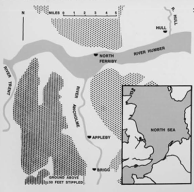
At high tide there was a clay and sand cliff to be studied, at the top of which we tracked down traces of what proved to be an early 1st century A.D. pre-Roman native settlement of the local tribe, the Parisi. At low tide, and when silting conditions were favorable, there was a choice between the pebble-strewn surface of an eroded platform of glacial Boulder Clay with a wide variety of fossils derived from rocks ranging from the Devonian to the Cretaceous, and in the opposite direction, preserved in shallow depressions in the Boulder Clay, a series of post-glacial deposits ranging upwards from a forest peat through what appeared to be a sequence of mainly estuarine clays of varying texture and content. These in turn were capped by more recent river silts which came and went according to the vagaries of tide and weather.
We began a more or less systematic program of observation of the peat and clays in about 1932 when a shift in the deep water channel in the estuary had cleared a long-standing accumulation of later silt. Over a period of several years we collected, amongst other things, an interesting and varied fauna of fresh-water mollusks from what had evidently been a swampy pool in the woodland which had formed the peat. This was ascribed on comparative faunal and climatic evidence to a date in the first half of the 2nd millennium B.C., or the earliest period of the local Bronze Age in England. Insect and plant remains in the peat, bones and antlers in both the peat and estuarine clays further whetted our interest; but for a long time human artifacts evaded our eyes and trowels. By the middle thirties, however, we had found one fine, black flint borer, and an increasing number of very soft decayed poles with ends showing axe-marks. There were traces too of trackways in the clay, made of stakes roughly interlaced with transverse poles, all quite light structures, the wood no more than an inch or two in diameter.
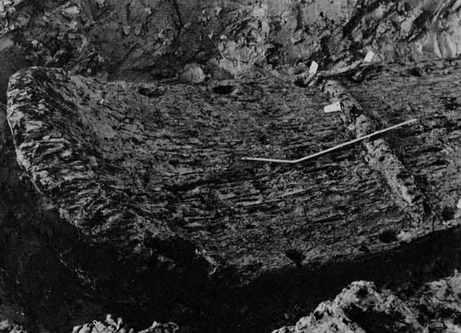
Then on a winter foray in late 1937, I came across the ends of three great planks laid alongside each other and just projecting from the clay. I called to my brother a few yards away that I had found a “Viking Ship.” He made sceptical noises; but came, looked and was soon convinced. Together we cleared the clay from a few feet to reveal that the planks lay edge to edge, were stitched together with withy bindings, the seams luted with moss and covered with wooden slats. Furthermore, there was a form of tongue-andgroove or “rabbet” joint between the planks. We had found a boat though plainly not a Viking one. A technique of separating “buttery” blue clay from nearly black wood buried in it at uncertain depths, the wood being of the consistency of hard, Cheddar cheese, had yet to be perfected. The first day’s photographs demonstrated all too clearly the need for improvement in the art of cleaning the remains to a state fit for recording and to do so without damage; on our second dig we did better than on the first.
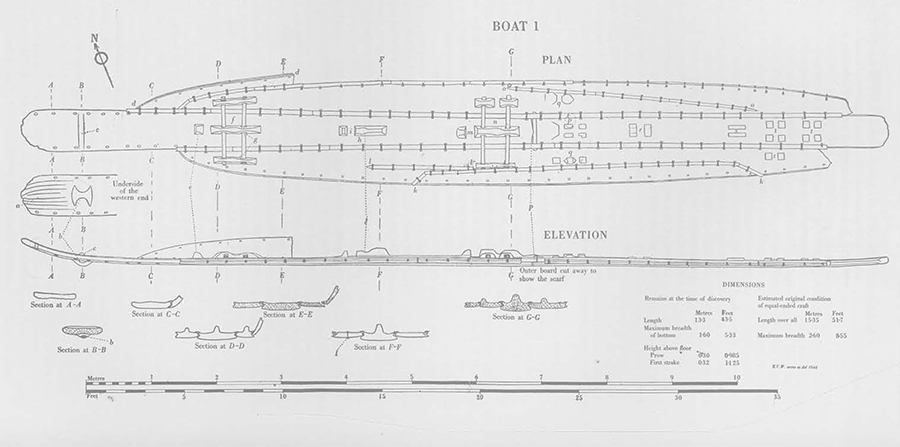
Our early enquiries of the late James Hornell, the acknowledged British expert on primitive boat construction, and others suggested that the only parallels for the more unusual details of construction were modern ones from the Indian Ocean and other places in the Tropics. We decided therefore to investigate the find further as a prelude perhaps to recovery. Up to September 1938, first between the two of us and finally with a total team of six, we carried out three separate digs, the extent of which was limited on each occasion by the fact that the site was uncovered for a maximum of five hours at spring tides and somewhat less at neaps. During this period the area chosen had to be excavated down to the surface of the wood, which was then cleaned sufficiently for measuring, drawing and photography. Each hole was then refilled to preserve the boat from damage. The first of the three digs exposed the western end opposite to that first discovered, giving a length of 13.3 meters for the part surviving. The other two revealed much of the superficial detail of two stretches amidships. In all, we were able to conclude that we had much of the bottom structure of a boat, the sides and ends of which were missing. It was of massive construction, the planks of oak (Quercus) being up to 65 cm. wide and over 13 cm. thick in places, stitched together at approximately 30 cm. intervals with bindings of cracked and twisted yew branches (Taxus).
During the winter of 1938-39, we decided to lift the measured length from the exposed eastern end which was showing signs of being endangered by the continuing erosion of the shelf in which the boat was embedded. The pieces would also provide material for study of methods of preservation. As the year 1939 progressed it became apparent that war was impending, and that there was little that could be done but wait and hope. My brother and I eventually departed for the army, and it became a matter then of seizing stray opportunities for observation and recording of any features exposed by natural erosion. Some further pieces in danger were removed in the hope that storage in a cool moist place on land was a safer prospect than the risk of being carried away by the river,
During one such visit in late 1940 I found the end of another very large plank some 60 meters to the west of the first. It was clearly part of a second boat and, as shown by a series of exploratory digs at intervals between 1940 and 1942 whenever home leave permitted, it proved to be an isolated and incomplete keel-plank of the same type as in the first boat although with significant differences of detail. Records were made of more than half of the find and the limits determined, all excavations again being refilled.
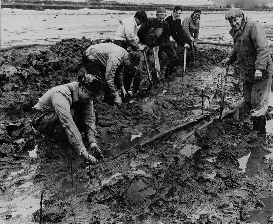
I was eventually demobilized in mid-1946 and decided on a program of recording what was left of both finds, which had suffered further damage in the intervening four years, especially the exposed eastern end of No. 1. With a small team of dedicated local helpers, a nearly complete record was achieved of the outline of the surviving part of No. 1 and much new detail exposed. At the same time I tried to secure the resources necessary to attempt a complete recovery. The effort was eventually successful and, by the technical standards of the day and with the limited resources available in immediate post-war Britain, a major undertaking was mounted in September and October 1946.
Our best hopes of a clean recovery of No. 1 nearly ended in disaster but no material was lost. No. 2 was manhandled out after cutting into suitable pieces. All the remains were transferred to the National Maritime Museum at Greenwich for cleaning, detailed recording and eventual conservation. It must be remembered that the handling of degraded wet wood of great age had always been the conservationist’s nightmare, and in 1946 such materials as Polyethylene Glycol had not been invented. Nor had polythene bags and sheeting which today provide such a convenient and secure method of wrapping perishable relics to ensure retention of moisture. Let it be admitted frankly that the attempt to stabilize the remains was largely a failure. What was gained was an accurate and complete picture of both finds and a detailed knowledge of how they were constructed and of the materials used. Parallel reports were published in two suitable national journals and I turned my attention to earning a living in industry. From indirect evidence of varying reliability I had speculated that the age of the boats might be about 250 B.C.
Although I continued to live nearby I must confess to having relaxed my watch on the bank during the following sixteen years. I did pay occasional visits, however, and in one area, not far from the site of No, 1, I found a regular supply of small parts evidently from a boat of the same type, but which at the time I assumed to have belonged to and drifted away from No. 1 as it lay abandoned in the mud in antiquity. In 1955 I gathered samples of these for possible radiocarbon dating (“invented” about 1950). A determination was eventually obtained in 1959 and, as will be explained in the passage on the age of the boats, its early date was a cause of much excitement. Again the matter rested, but in early 1963 I spent several weeks on an extensive business visit to India, Pakistan and Ceylon during which I was able to feast my eyes on the immense variety of very primitive boats still constructed by traditional methods in those parts. This and some “travel-reading” on the prehistory of India stimulated a renewed endeavor to further research and, when I returned home to the end of an unusually severe winter and the ensuing thaw, the conditions were ripe for more discovery.
The urge came on me in the middle of a Sunday in mid-March, and I carted my wife and two youngest children down to the river hank to find the tide perfect and the clay much better exposed than for a number of years. With my son Roderick I headed for the area where small finds had been made and suddenly spotted, almost under Roderick’s feet, an alignment of ends of yew bindings. This could only indicate the presence of a plank immediately beneath the clay, so I called to Roderick, “Don’t move; you are standing on a boat!” A brief investigation showed that there were indeed one or more typical oaken planks, and the probable outline was staked out with metal rods, a quantity of which by pure chance were lying about near the water’s edge. This was a precaution (as it proved, a very necessary one) against the site being obscured by a return of the silt which had made observation difficult in the late ’50’s and early ’60’s. Within a month the human and material resources had been marshalled, the piece extracted and the way prepared for modern conservation treatment, and the extraction of much new evidence by the methods which had become available since the activities of 1946.
The fieldwork—or should it be called “mudwork”—which had yielded the three major finds over a period of twenty-six years had also produced several lesser discoveries: a bronze knife, some pottery, a baked clay sinker and various wooden objects. The last included a nearly complete paddle-blade and the shank of another, most of a “tingle” or patch for repairing a boat and a large, trimmed fork of oak interpreted as a side-member of the frame of a windlass of a type which can be paralleled in Finland in historic times.
Here then was the material evidence and to it could later be added a substantial body of dating evidence, independent of any inferences which might be drawn from cultural or other parallels.
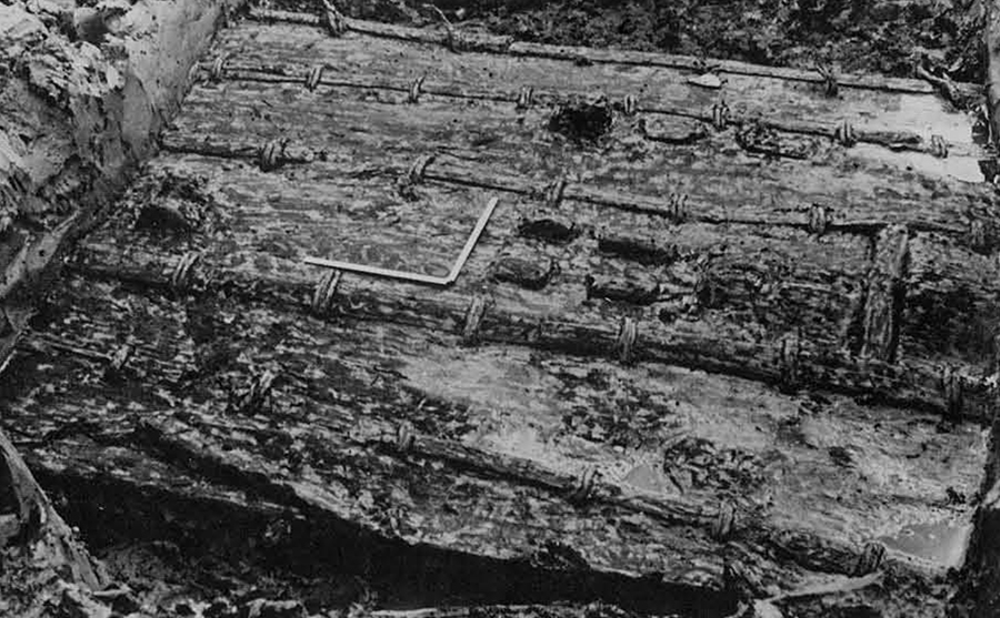
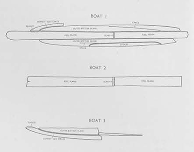
The boat-remains consisted in the case of No. 1 of most of the bottom structure with a small part of the first strake on one side preserved; of much of a keel-plank in No. 2; and of about half a garboard strake and the adjoining first strake of the side in No. 3. The main method of attaching the planks to each other was by stitching with bindings of yew. In addition, the bottom was braced by a system of transverse battens passing through cleats left standing on the surface of the planks when they were dubbed out of the solid log. I call them planks but they were more slabs than planks. Much ingenuity was displayed in the methods used for jointing the edges of the planks, altogether four different styles being identifiable, adopted consistently down to the smallest detail in each of the three examples.
Much of this ingenuity was evidently designed to protect the stitches from abrasion. Grounding would otherwise simply have wiped projecting stitches off the bottom. In practice the only stitches exposed on the underside were those used to repair cracks, all others being either buried inside the seams or countersunk in grooves. There were a number of blocks and projections left standing on the planks, apart from the cleats, or remains thereof, used to secure the system of cross-battens. Some pairs formed slots which have the appearance of being designed to locate either timbers laid across or spars rising vertically from the bottom. The purpose of any of them, however, must remain conjectural until more complete examples are found. The bottom was undoubtedly flat with a gentle rise at the better preserved end where the keel-plank was cut out of its log to produce as high an upturn as could be cut from the available tree. Under the forefoot was a beautifully carved cleat with widely flaring “wings” which I have interpreted as contrived to secure a circumferential lashing ’round the end, the wings again designed to protect the rope or other material. The comparable part was missing at the other end and, on the presumption that the boats were equal-ended, the length of the bottom can be estimated as approximately 151/2 meters. The breadth of the bottom was 1.60 meters. The precise angle between sides and bottom was preserved in Nos. 1 and 3, which gives a useful lead to the original beam; but the overall length of a complete boat is more difficult to deduce, since it is largely dependent on the method of “closing the ends” which, in the absence of the parts in question, is necessarily still speculative.
I have made several attempts to arrive at rational hypotheses for the nature and appearance of the missing parts. The cut or broken bindings on the outer edge of the first side-strake indicate that there must have been at least one other and, if that were of the same width as the two examples found, this would have produced a boat which would not only have floated, but in the enclosed waters of estuaries or rivers would also have been able to carry some cargo as well as enough crew to paddle a boat of the size and weight. If higher sides were required, three strakes each side is by no means an impossibility. I have worked out the geometry of these two hypotheses by making a small balsa-wood model. This still leaves the ends open unless the height of the end of the keel-plank were raised either by bending or by the attachment of a board or similar fitment. Owing to the thickness of the plank and the degree of local deformation necessary, I have in recent years ruled out the possibility of bending. Our boatbuilders seem rather to have been wedded to the idea of chopping and shaping mass timber to arrive at the forms required in their massive planking.
A further hypothesis for closing the ends is based on observation of the modern Portuguese fishing boats which also have flat bottoms upturned at the ends. In these, the side-strakes mate with their opposite numbers on the other side beyond the tapered point of the keel-plank. There is a very rigid frame just short of either end; but no use is made of stem or stern posts. Something of the same sort would provide a highly satisfactory solution to the North Ferriby problem, and I have again worked out the necessary geometry on my trusty balsa model and given it a level gunwale-line. It could well be that for inland waterways no more height at bow or stern would be needed; but if some more elaborate “ends” were wanted the addition of embellishments would not be difficult. Some sort of thwarts or cross beams at gunwale level would have been a necessity and I have postulated these at stations marked by the presence of certain of the slots on the keel-plank.
If all these hypotheses and conjectures are put together and touched up with an imaginative pen we get a craft which would have floated, moved under the urge of paddles and carried some cargo. She might even have had one or more short masts to carry sails (of leather if the Gauls of Caesar’s time are a guide). I’ve named this frolic of the imagination the “Skylark,” but despite the name there is much solid thought and research behind her appearance. One thing is sure, and that is that she would have been horribly leaky and required constant bailing.
What were the conditions when the boats were in use? We have one incomplete boat and pieces of two others, together with traces of the sort of bank-furniture which might be expected at a place from which they were worked. There were clear indications too of deliberate dismantlement in all three examples. Boat 3 in particular had a regular bed of cut alder poles laid beneath it. All this suggests a fairly permanent use of the site which, in modern parlance, might be called the northern terminal of an ancient Humber ferry service. For cargo the most likely candidate is live cattle.
To get an idea of who might have used them brings in the question of dating. We have had serious problems over radiocarbon determinations because most of the material has all unwittingly been subjected to preservative treatment which renders it useless for this dating technique. Enough clean material has, however, been found to give us a range of radiocarbon dates which is mutually consistent and also ties in with the dating of other similar deposits in the areas. The oldest date is that for parts of No. 2, determined by radiocarbon as within the span, 1596-1483 B.C. (two runs). After calibration by the Suess method, this gives a date in calendar years of about 1800 B.C. One of the young alder poles under Boat 3 gave c. 1350 B.C. in calendar years, and the possibly suspect small pieces tested in 1959 gave c. 800 B.C.
The oldest• relics are thus a thousand or more years older than any other planked boats ever found in Europe, and outdated in terms of antiquity only by the Pharaoh Cheops’ “sunships” from the rock-cut crypt before his pyramid. Our archaeological context in East Yorkshire is that of the local Early to Middle Bronze Age, and it is indicative that the only measurable axe-scar (on Boat 2) is of a size which matches most closely the earliest type of bronze axe found in the area, the so-called “Flat” axe which is wider in the blade than any of the later types. There is evidence from burials and casual finds of metal objects of widespread occupation of the country around the Humber basin at the appropriate time. From the dating evidence it would appear that the bank was used for boats and their upkeep, repair and probably building over a period of several centuries from the middle of the 2nd millennium B.C. by bronze-using people. There is no reason to suppose that these were any but the local inhabitants.
The search for parallels soon revealed that another specimen of the same class had been found in a brickyard at Brigg in Lincolnshire in 1885. This was a bottom structure only, with no trace but the cut or broken fastenings to indicate the existence of sides. She was referred to in the meagre published records as a “Raft,” being completely flat. She was stitched—in a style different from that used at North Ferriby- and the bottom was stiffened by battens passing through cleats, as at Ferriby but spaced out differently. She had five planks each 46 feet (12.2 meters) long and was all of oak. Her date is not yet precisely known, but may be determinable as fragments have been preserved in local museums. From such indications as have been derived from evidence of other finds nearby, it is possible that the Raft is younger by several centuries than the Boats from North Ferriby.
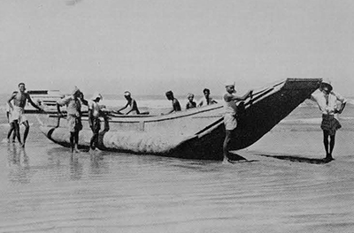
There are no other ancient examples of the type known to me, but modern or historic parallels for almost every detail of construction in the Ferriby/Brigg series can be drawn from the coasts of the Indian Ocean, from the South Pacific, from Central Africa and from the rivers of Siberia. One that is startlingly close in concept as well as method is a type of large fishing boat still to be seen near Colombo in Sri Lanka (Ceylon) and apparently known as a Mahadalpuram, notable for its flat bottom braced with cross timbers, upturned ends (equal at bow and stern), steep sides with thwarts and, to correct an obvious problem in boats of the class, a pair of dugout logs along either chine to give fore and aft stiffness. I could illlustrate several others with pictures, but the message is much the same.
For written parallels I should like to start with Lionel Casson’s fascinating reinterpretations of classical authors. Odysseus’ raft which he made to escape from Ogygia was plainly sewn. So too were the Greeks’ ships beached before Tray. Casson cites other references including one from Vergil, and the conclusion can only be that there was a tradition surviving in the Mediterranean into Imperial Roman times, based on underlying memories of sewn boats which must have preceded the mortice-and-tenon method of joining planks which became the standard in classical Greek and Roman times. More recently there is this from The Travels of Marco Polo:
Their ships are very bad, because they are not fastened with iron nails but stitched together with thread made of coconut husks. They soak the husk till it assumes the texture of horsehair: then they make it into threads and stitch their ships. It is not spoilt by the salt water, but lasts remarkably well. The ships have one mast, one sail and one rudder and are not decked; when they have loaded them they cover the cargo with skins, and on top of these they put the horses which they ship to India for sale. They have no iron for nails; so they employ wooden pegs and stitch with thread. This makes it a risky undertaking to sail in these ships, And you can take my word that many of them sink, because the Indian Ocean is often very stormy.
Perhaps even nearer the mark is an early 19th century record of the boat-making practices of a tribe called the Schitiki of the Kolyma River region of Siberia. One Captain James Burney in his Chronological History of North Eastern Voyages of Discovery published in 1819 quoted another traveller called Martin Sauer as follows:
The planks were sewed together with twisted osiers and fastened to the timbers only by leather straps in lieu of nails or pegs. The interstices were stuffed with moss and seams were covered with laths to prevent the moss being washed out. Notwithstanding the slightness of their construction, these boats were decked. This then has been my personal “expedition,” one that has already lasted over thirty-five years and is still continuing at the desk, in the library and laboratory and on the mud. We so badly need another specimen with the sides and ends preserved!
Southern Iraq, ancient Sumer and Akkad, is a land of contrasts. Rapid modernization has brought tractors, new crops, and industrial factories. But certain agricultural and irrigation practices, construction techniques, and many other details take one back thousands of years. Change amidst stability, or stability despite change, may be said to characterize not only today, but millennia of Mesopotamian history.
Settlement patterns and land use have been shown by archaeological surface survey to have been tied to shifting watercourses, problems of salinization, depletion of land, and movements of population. Remains of villages, towns and cities lie alongside half-buried ancient canals in the middle of the desert. Some urban centers were important enough to survive longer than most. One such site was Nippur, which came into existence some time prior to 4000 B.C. and was not abandoned until about A.D. 1000.
The history of the Nippur region during the past one hundred and twenty years shows how extreme and precipitate changes in local conditions can be.
Around 1850, various British visitors reported that they were obliged to use boats to reach Nippur. The area for miles on all sides [sic] sion. Among the tablets were contracts dated to the 34th and 35th years of Hammurabi, and one dated to the 13th year of Samsuiluna. We thus have about a twenty year bracket (1756-1736 B.C.) for the dating of the house. Also found among the tablets was a literary text in Sumerian.
Below the Old Babylonian level are older, Isin-Larsa, houses. The series of whole and fragmentary pots plus the sherds from WB should help to discriminate Isin-Larsa from Old Babylonian types. This is a range of pottery that is as yet inadequately distinguished.
Probably the greatest importance for future work is the knowledge that the WB area gives excellent opportunities for reaching early levels with little overburden. Our Isin-Larsa levels are about nine meters above plain level. Strata such as those of the Early Dynastic Period, that elsewhere have been found under meters of later debris, or below plain level, may at this spot be found relatively easily.
The final operation for this season was a small pit, SQ, sunk in a low area northwest of the ziggurat in the eastern part of the site. This excavation was carried out by Dr. Peter Mehringer, an earth scientist from Washington State University, in order to sample strata that may give a pollen and faunal record of climate at Nippur over the past few thousand years. Carl Haines, the former director of Nippur, who was with us as a special consultant, remembered that when he made soundings in this locality in 1951-52, he observed a blackish layer about a meter below plain level. He thought that this might be evidence of an ancient swamp. Mehringer found this and another stratum that he thinks were swamp sediments. His analysis and report will appear at a future date.
Looking at the season as a discrete unit of research, we can point to several notable accomplishments. In our main area, WA, we discovered what seems to be a major temple, although we must now try to determine its relation to its surroundings. In the strati-graphic pit, WA 50c, we have, I think, demonstrated conclusively the use of plano-convex mud bricks in the Akkadian Period. Also, we have from this cut a large, well stratified collection of potsherds, including glazed specimens, that will help to set up a better ceramic chronology. The changes in glazes may cause us to reassess our understanding of glazing, especially when detailed chemical and microscopic studies are made. The private house area, WB, has likewise furnished good ceramic criteria from floor levels dated by tablets to distinguish the important Isin-Larsa/Babylonian sequence.
The season must also be viewed as a link with past work at the site, and as the first part of a new program of research. We will continue to work in the trenches opened this year, trying to answer the questions raised. We intend to expand, especially in private house areas, and sample other parts of the West Mound and the plain level around it. Sherds on the plain indicate possible locations of early material without late overburden. In conjunction with such soundings, attempts will be made to trace more of the city wall.
In terms of method, we hope to continue combining old techniques of excavation with new ones, trying to bring in scholars and students from anthropology, paleobotany, and other fields whenever possible. For a site as complex and gigantic as Nippur, we need as much help from various disciplines as we can obtain. Digging merely for objects or for history is no longer justifiable. Piecing together cultural evidence, establishing the historical relevance of an object, a building, or a city, and trying to relate these to environmental or other factors as elements in a larger process are the task of archaeology today. For Mesopotamia, elaborate research designs may be possible. However, it is my opinion that until a firm ceramic sequence is established, such research must be questionable. The main task for the next few years must be the setting up of that sequence, with an eye to future cultural and historical studies. It is our intention at Nippur to be open to new ideas, and try new methods, but to focus on the basic work of good recording and pursuit of a reliable sequence. It may not be as exciting as other programs, but it will be more important