A few miles inland of the vast tidal flats of Novia Scotia’s Minas Basin lies a wasted field of red sand, surrounded by recent stands of alder and poplar, and shadowed by the dense forests of fir and spruce that march northward up the slopes of the Cobequid hills. Here, through the summers of 1963 and 1964, the Robert S. Peabody Foundation for Archaeology, the National Museum of Canada, and the Novia Scotia Museum joined forces in the excavation of one of the most important “early man” sites in North America–the Debert site.
As is the case with most such paleo-Indian sites, the discovery of the Debert material was quite accidental. During World War II, Canada’s Department of National Defense established a military training and staging area near Truro, Nova Scotia. The inevitable bulldozers charged about, and a relatively flat field of some eight acres appeared on the shoulder of a height of land. Eventually, artifacts were noticed on the scraped sandy soil, and over a period of years a rather extensive surface collection was amassed.
But it was not until the early 1960’s that the existence of fluted projectile points in this collection came to the attention of the R.S. Peabody Foundation and the National Museum of Canada. In October of 1962, Douglas S. Byers and Richard S. McNeish, representing those respective institutions, located the site area and made several test excavations. June of 1963 saw the beginning of full-scale excavations of the old field at Camp Debert.

“Early man,” “early hunter,” or “paleo-Indian,” by whatever term we call him, was the first-comer to the Americas, and a mere infant in terms of his archaeological acceptance. The gradual establishment of an evolutionary scheme for man in the Old World naturally provoked attempts to find parallel developments in the New World. But the resounding failure of these endeavors sponsored an archaeological fiction dictating that man had arrived, presumably carrying full-blown cultures on his back, sometime after 2000 B.C. It was not until the late 1920’s, with the discovery of artifacts in association with extinct bison in late Pleistocene deposits near Folsom, New Mexico, that New World man was conceded more than a modest antiquity.
During the years immediately following the Folsom discovery, the American West was subjected to an archaeological scouring that made the Easter Morning egg-hunts on the White House lawn seem quite tame. A remarkable array of tools and information have been brought to light in the years since the Folsom excavations of 11927 and 1928, and the problem of organization and evaluation of materials increases at a startling rate. At this moment, paleo-Indian is assumed by definition to be the first human occupant of the New World, and his cultural development appears to have run through at least two major phases; the question of how many more such phases can be encompasses by the paleo-Indian continuum is a prime source of argument among New World archaeologists.
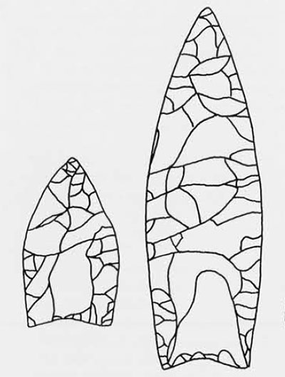
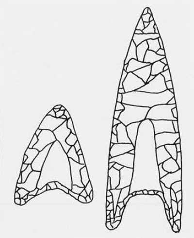
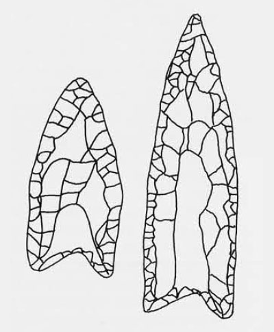
The fact that even two such phases had existed appeared with the excavations of the gravel pits of Blackwater Draw near Clovis, New Mexico, beginning in 1933. In a layer of diatomaceous soils were found the burned bones of extinct bison, and with them a collection of projectile points and tools quite like those found in the original Folsom excavations. But beneath this Folsom level, and separated from it by several layers of sterile sand, was a bed of grey speckled sand which produced not only the bones of extinct elephant and horse, but also a quite different tool assemblage now known as the “Clovis” or “Llano” complex. The Clovis hallmark is a long lanceolate projectile point with nearly parallel or slightly convex sides and having a flute or groove running up each face from the base. The base itself is slightly indented, and the basal portions of the edges are ground in order to round them somewhat. A fairly heavy point, it ranges in length from perhaps two to five inches, but is usually somewhat more than three inches long. Although the rough form of the point is achieved through percussion flaking, the final finishing edge and thinning of the point are done by pressure flaking.
Of the two horizons, the later Folsom seems to be the more limited in both time and geographic range. Generally associated with now-extinct bison, Folsom artifacts have been found predominantly in the high plains of the eastern slopes of the Rocky Mountains in a band running from northwestern New Mexico through Colorado and Wyoming to Montana and southern Idaho. Radiocarbon dates and the geologic stratigraphy place the Folsom horizon roughly in the 9000 to 7500 B.C. range.
The Clovis horizon is another matter altogether. The Clovis artifacts of Blackwater Draw have been duplicated, or nearly so, from southern Arizona to central Texas, with a possible excursion into Mexico. And the geologic-radiocarbon estimate of the Clovis time-span is perhaps 11500 to 9500 B.C. From this point on, however, the Clovis assemblage seems to have developed an unlimited number of first and second cousins, for variations on the Clovis theme have been found in South and Central America, Canada, and throughout the continental United States. Aside from the occasional isolated point, clusters of finds have appeared in the East throughout the Ohio and Tennessee drainages, and marked assemblages of Clovis-like paleo-Indian material have been found in Alabama, North Carolina, southeastern Virginia, the Shoop site in eastern Pennsylvania, the Reagan site in Vermont, and the Bull Brook site near Ipswich, Massachusetts.
In most of these sites, the projectile points differ slightly in outline from the classic Clovis form of the Southwest; but the technique of manufacture and the very existence of fluting, lacking in the later Archaic stages, help mark these assemblages as paleo-Indian. Both the Shoop and the Reagan sites consisted entirely of surface finds, and the stratigraphy at Bull Brook had been so thoroughly disturbed by natural forces that it was impossible to reconstruct any true picture of paleo-Indian occupation in the Northeast. Scattered charcoal flecks at Bull Brook gave a radiocarbon-dated range of 8000 to 6600 B.C. But none of these sites permitted speculation as to when the first hunters reached the Northeast, where they came from or by what route, where they went, or what the climate and countryside were like while they were here. It was assumed only that the paleo-Indian hunted this area sometime after the last of the continental ice sheets had retreated into northern Canada. What was needed was another site in northeastern North America…
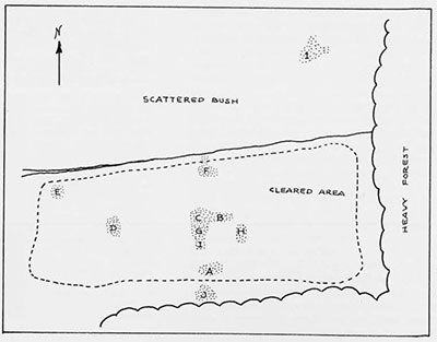
Clear a dense spruce-fir forest from a gently sloping hill, scrape off the top layer of sandy soil, and turn loose the Nova Scotian wind for twenty years; a party of about a dozen people began looking for paleo-Indian in this waste in June of 1963. Stands of alder and poplar and a scrubby heath skirted the open area which was dotted with humps of sand held in place by clusters of blueberry bushes; between these berried hummocks were broad expanses of red wind-scoured sand which shifted slightly with every breeze–usually into one’s shoes and down the back.
The digging party was small, but marvelously congenial. Doublas Byers directed the project, while George MacDonald from Yale University served as crew foreman. George’s wife, Joanne, divided her time between digging and the thankless job of remembering everything everyone else had forgotten; her constant padding about earned her eventually the most tattered and disreputable sneakers in all of Nova Scotia. Roger and Brenda Powers had come east from Idaho diggings to see if eastern archaeology was really true. Six Nova Scotian students filled out the roster, and, of course, the writer who was getting his archaeological feet wet.
Quarters for the crew were varied. The military made available a few beds for the younger single men at Camp Debert, while the rest of the party obtained quarters in Truro, a few miles to the east. The camp-based crew had all meals with the Army, the others ate noon meals there and found the balance of their edibles in Truro. Camp Debert made laboratory space for us on the base, and, bless them, granted evening privileges at the NCO beer-mess.
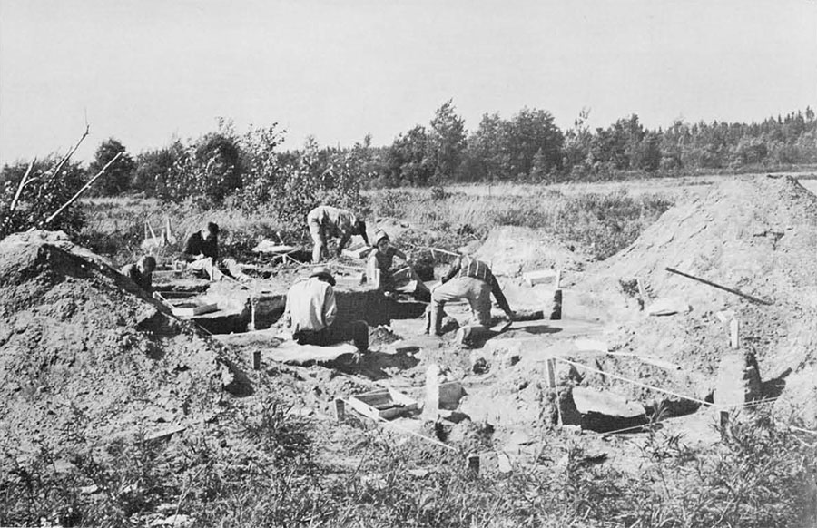
A plane-table map of the site was made and stakes set out for a hundred-foot reference grid. The field was then searched for surface artifacts, their positions plotted, concentrations noted, and excavations commenced in “A” section, midway along the southern edge of the cleared area. At this time the stratigraphy of the site was unknown and all work was done with trowels. Artifacts turned up almost immediately in “A,” but first attempts to correlate artifact position with soil horizons were in vain. A fifty-foot trench was then shoveled across the edge of the section, running into a low dune-like rise at the southern edge of the field, and gave the first indications of the amount of disturbance involved. Post-war blow sand had sifted across the site and become trapped in the brushy cover there, concealing the splendidly-colored and rather hopeless layers of bulldozer-dragged soils. Below the line cut by the bulldozer blade, we found a zone of white leached sand of varying thickness which topped the red-brown sands of the B horizon. This red sand appeared deceitfully homogeneous until we discovered the remnants of “tree-throw” in this layer, and began to speculate upon the possible number of trees once rooted in this level and blown over by storms, thereby mixing the nearest artifacts. Excavation by trowel now became mandatory in order to recapture the original stratigraphy.

The first few weeks improved our education on another natural factor of the site: bugs. Those lovely, tall, green, cool forests to the east of the site harbored the most voracious mosquitoes in North America. And the low scrub on the fringe of the site produced not only pretty little flowers and blueberries but hordes of black flies as well–all of them hungry. All in all, we found the area populated by no-see-ums, black flies, mosquitoes, deer flies, horse flies, and a creature of terrifying proportions known as the “moose fly”; there were, of course apocryphal tales of a “mastadon fly.” Our kits of trowels, rules, and plumb bobs soon bulged with an assortment of sprays and lotions to repel the attackers, and with various ointments to soothe the punctured hide. A frenzied flailing of the arms in the midst of conversation was commonplace, and the more adept learned to kill the invader with a smart blow of the trowel without too serious bruising.
The outlines of “A” section artifact distribution were soon defined, and part of the crew moved uphill to begin excavating “B”, another concentration a few hundred feet north of “A”. “B” presented us with our first view of “bedded sands,” layers of finely laminated sands lying below the red B horizon and atop the glacial till, with never an artifact. Its pattern resembled somewhat that of watered silk, and the question of its deposition, by wind or water, was not resolved until the 1964 season.
Roger Powers set to work in an area just west of “B” to reopen and enlarge one of the 1962 test pits, and uncovered the first projectile point fragment of the season–paleo-Indian paydirt! Equally memorable was the morning Roger grubbed about to pull out what first appeared to be a round black rock and found himself holding a smoke bomb by the business end. He was decidedly uncomfortable holding it, but afraid to let it go, and I must admit the rest of the crew acted as though Roger had a bad case of B.C. The Army came to the rescue, informed us that it was now defunct, and that we might find more since the field had been used as a practice and demonstration area during the war. Indeed, we did find more, and rather casually accumulated a small pile of them by the end of the season.
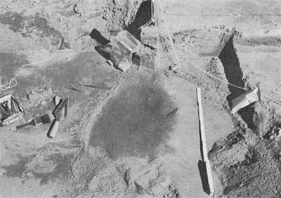
“A” section then produced the first hearth, Feature 3, with more than seventy artifacts and several hundred chips both in and around it, and the charcoal was carefully collected for radiocarbon dating. Almost immediately Feature 4 hearth appeared twenty feet southeast of Feature 3, and the whole area was stripped to hearth level to reveal the two spots of charcoal-stained sand, each tucked into the southeastern side of bumps in the till and bedded sands.
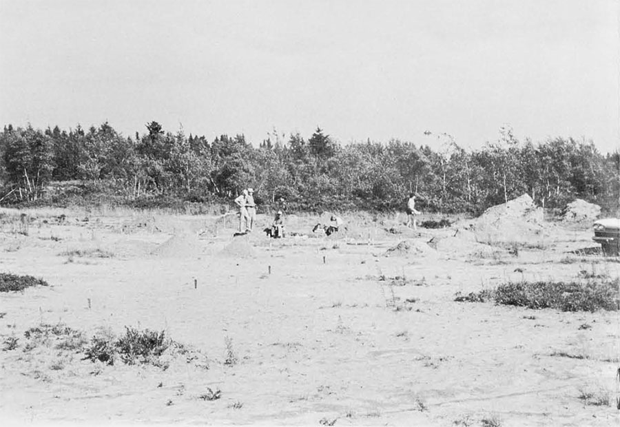
Roger Powers was sent off with plane table and stadia rod to make a countour map of the entire area. Padding along in his footsteps were a small crew of diggers sinking test pits in a sandy hillside to the north of the field, designated Section “1”.
The last week of the 1963 season centered around “D” section, well to the west of the previously excavated areas. Here a collection of artifacts in remarkable numbers and a chip count of more than a thousand led to the opening of an area perhaps thirty by twenty feet, and several artifact- and charcoal-filled pits appeared. True to form, time was running out, but the crew were able to salvage enough charcoal for dating purposes and the vast majority of the artifacts. The exposed area was then covered with large sheets of plastic film, and the whole area refilled with dirt, to be re-opened in the 1964 season.
The following winter saw a preliminary analysis of the artifacts, a grant of funds from the National Science Foundation for the next season, and several dates from the University of Pennsylvania radiocarbon laboratory on the charcoals from the hearths excavated in 1963. The preliminary dates placed the Debert occupation at fully a thousand years earlier than the Bull Brook site, and equalling late Clovis or early Folsom dates in the western United States. Armed with these remarkable dates, and now knowing what to expect in the way of artifacts, we had as our main objectives in the 1964 season to enlarge the artifact collection for a more valid statistical study, define the limits of the site, obtain more charcoal to confirm the preliminary radiocarbon dates, and to work out the ecologic and geologic history of the site.
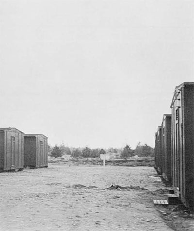
For the 1964 season, the National Museum of Canada and the Department of National Defense refurbished five small barracks for our use: two of them were divided into small apartments for married couples; one of them into to sizeable dormitories for the single students; one was used as a laboratory; and one as a kitchen-dining hall with wash rooms at the end. Quite plush they were, too, replete with sinks, electricity, stoves, beds, cookie cutters, hot water, blankets–all the endless variety of oddments needed to feed and house a crew of thirty. A skeleton crew arrived about the third week of June to put the house in order before the arrival of the students at the end of the month. We spent our time building drawing boards, work benches, kitchen shelves, benches for the dining hall, and constructing on the site what was undoubtedly the finest privy in Novia Scotia.
The digging crew of the second season included students from Nova Scotia, the University of Toronto, the University of Maine, Dartmouth College, and Yale University. George and Joanne MacDonald returned as crew foreman and chief picker-upper, and the Powers were back, having entered graduate school at Wisconsin. Douglas Byers brought his wife, Dorothy, along as chief-of-commissary and to help the Nova Scotian cooks. A digging day was rather full, what with breakfast at seven o’clock, digging from eight to half-past twelve, half an hour for lunch, and then digging again until half-past five. The evenings were reserved for lab work, sometimes far into the small hours, and occasional desperate trips into Truro to the laundromat. Saturday afternoons and Sundays saw the more energetic trotting off to Antigonish for the Highland Games, to Halifax to shop, to Parrsboro to collect rocks, or to Tatamagouche for no reason at all other than the rather splendid name.
Feature 7 in “D” section was re-opened in short order, the plastic film removed, and a summer-long program of meticulous excavation began to trace the extent and origins of the pits. Eventually it was discovered that although there had been occupation o the sands immediately above the till here, two later tree-throws had formed the pits and disturbed much of the original stratigraphy. A series of squares opened on the perimeter of Feature 7 produced the first complete excavated point, but also indicated the sharply confined character of Feature 7.
“C” section was re-opened near the first of the smoke bomb episodes of 1963, and excavations continued there for about two weeks. A small concentration was discovered in the far northwestern corner of the field, and “F” section on the north edge of the area occupied a large part of the crew for eight weeks. “G” section near the middle of the field eventually produced the largest exposure of bedded sands and some time was spent there in plotting the patterns of grain-sorting in an effort to determine the direction of the prevailing winds of the time.
With so large an area to explore, we built wooden frames which supported screened boxes on chains. With two people shaking this screen and one person shoveling dirt into it, we could carve quick trenches through unexplored areas, and define the limits of new sections in much less time than was required in troweling. The girls informed us that screen duty was great for the shoulder muscles and quite tummy-slimming. One such trench revealed a patch of charcoal, and shoveling was stopped immediately in favor of more careful excavation. We discovered a small hearth settled in the middle of a gully in the till. This gully, irreverently termed the “snake roast,” was perhaps a foot wide, a foot deep, and ran erratically for some thirty feet. It lacked all the requisite features of normal water drainage, and a five-foot pit dug laboriously into the till revealed no frost-action origin for the “snake roast.” We still don’t know quite what to make of it.
From late July through much of August the countryside swarmed with blueberry pickers. Afraid some unsuspecting soul might fall into one of our pits, or inadvertently break down some critical sidewall, we erected a number of signs reading: “VACCINIUM ENDEMIC. Unless properly protected, enter at your own risk.” Many of the blueberry pickers read the signs, turned about, and went elsewhere, despite the fact that the sign merely stated, in botanical Latin, that blueberries grew there.
The last section opened was “J”, south of the field in a veritable jungle of scrub heath and poplar. “J” produced a large collection of artifacts, and the closing bit of story-book drama for the Debert site. Most of the crew left the Saturday of Labor Day week-end, leaving a skeleton crew to polish off the last odds and ends and to close down the camp. One final hearth remained to be excavated in “J”, and four of us approached it rather casually on Labor Day morning. We reached the bottom of the deepest and perhaps the richest single hearth of the Debert site just as darkness fell that evening. The bulldozer arrived on schedule at seven o’clock the following morning to back-fill, and once again the Debert site was just a scruffy-looking field.
And now the second phase of the Debert Archaeological Project has begun–the analyses, all of which will take many months before completion. Our resident geologist this past summer, Harold Borns of the University of Maine, is working out the data he has obtained on raised beaches to determine the relative positions of sea levels and glacial fronts in the area. Peat bogs were cored, and pollen analyses will be made to determine the vegetation history of the area since the last ice sheet rode over the Debert side. Sedimentation studies hopefully will confirm our suspicions that the bedded sands were wind-blown, and perhaps give us an idea of the climate at Debert eleven thousand years ago. Samples of charred and decayed roots and of charcoal from the hearths have been sent off for species identification to supplement the pollen analyses. Hearth charcoals and cores from the peat bogs of the area must be dated at the radiocarbon laboratory. And the long, tedious analysis of the artifacts has begun. Unhappily, there are no faunal analyses to be made, for no bones were recovered; so acid is the soil of the spruce-fir forest cover that all bones have long since been dissolved.
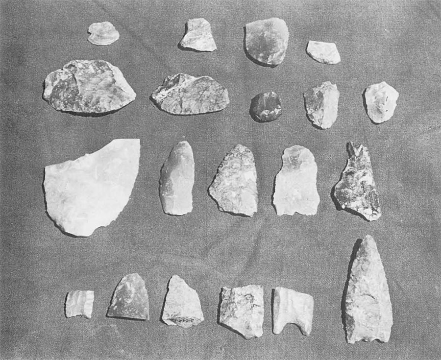
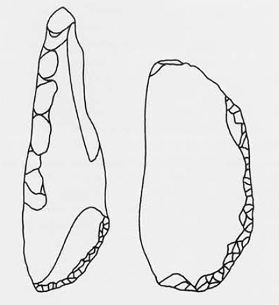
But we can speculate a bit about the artifacts. The greater portion of artifacts from the Debert site were scrapers, both end scrapers and side scrapers. The former appear to be much like end scrapers from other paleo-Indian sites, both eastern and western–some snub-nosed, some broad-nosed, some flat-backed, some of them with ridges or keel-backed, and some evidently tanged for hafting. Many of the large side scrapers appear to have been made on large, relatively thin flakes, whereas those from the Bull Brook site seem to be longer, thicker bodied, and intended for hafting. The “eared” scraper from Bull Brook was found at Debert. This is an end scraper with tiny, beautifully worked spurs or points on either edge of the scraper. Another form of graver-tipped scraper was found at the Reagan site in Vermont, and other forms at the Shoop site in Pennsylvania. These gravers were also found as single tools, rather than multipurpose, sometimes with as many as five tiny worked spines around the edge on one face only.
Wedges were quite prevalent at Debert, although little data is available to indicate their appearance in other northeastern sites. These are sturdy flakes, worked from both ends to form sharp edges on opposite sides, and used presumably as wedges to split bone and wood. Their sharp wedging edges show heavy concentrated battering at the points of contact.
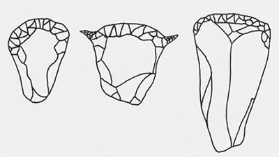
Projectile points turned up in a wide variety of forms. One crudely made point was less than one and a half inches long, yet fluted nonetheless. And its opposite number, the work of a master craftsman, is about five inches long. One or two of the points bore a strong resemblance to those of the classic southwestern Clovis, and some to those of the Bull Brook site. In general, the Debert points seem to have a smoother and more gently curved outline than do the Bull Brook points which are fundamentally triangular, or show a slight break from triangular to parallel sides midway along the edge. While some of the Debert points have only slightly indented bases, a number of them have very deep indentations, producing an odd “eared” effect not common in the Northeast. There is almost no indication of the heavily flared base of the “Cumberland” group of the Tennessee Valley, and little resemblance to the points of the Reagan site. Generalizations on the basis of projectile points are hazardous at best, however, for each point depended upon the individual stone, the man making it, and the fact that no man will make two points exactly alike. So we must wait for a complete analysis of all the material, and then we shall know a bit more about the early hunters, thanks to Debert, the earliest site in the Northeast. And, of course, what will be needed is another paleo-Indian site in the Northeast.