During the winter of 1961-62, Admiral Th. Voutsaras, President of the Federation Hellenique…des Activities Subaquatiques, received reports of a group of ancient columns lying on the sea bed off Cape Spitha, the northernmost point of Sapienza Island, about a mile from the small port of Methone on the southwestern Peloponnesus. Amphoras and amphora sherds were also reported to have been found by several net fishermen in the area.
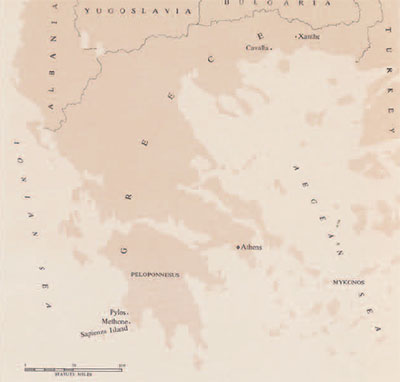
The windswept corner of Greece is situated on what has long been a major shipping route. For centuries, passing mariners have tried to escape the fierce and sudden storms of the Ionian Sea by rounding the “corner” and sailing through the channel between Sapienza Island and the mainland into the sanctuary of the harbor; the small, blinking light now on Cape Spitha warns modern ships of the dangers which accompanied this maneuver. And Methone was more than an occasional refuge; its strategic location was prized by contending nations. First settled in Mycenaean times, its long and violent history included a succession of sieges, bombardments, and occupations. During the Middle Ages, its period of greatest prominence, Methone became an important port of call for the Venetian navy.
Today, Methone’s historic remains have almost completely disappeared except for the layers of architectural elements built into the walls of the great Byzantine-Venetian-Turkish castle which dominates the village. But one of the traces of unidentified and forgotten buildings which survives in the castle is the large fragment of an Oriental pink granite column, 3.67 meters high, standing in front of the keep; it is part of a monument set up by a Venetian admiral, Francesco Bembo, in about 1494. The column may well have come from an early Christian basilica of which no other trace remains above ground. The reports reaching Athens last winter of a shipwreck of columns and of numerous amphoras plainly suggested that the waters of Methone still hold historically important debris from may forgotten catastrophes.
Admiral Voutsaras obtained the necessary permissions for a survey team to investigate the Methone region under the supervision of the Hellenic Federation. A small but diversified group of specialists was assembled by one of us (Throckmorton), who served as technical director of the survey and its photographer. The six man team consisted of four experienced divers (Nikos Kartelias, a Greek ex-navy diver who represented the Federation; Roger Wallihan, an American who provided essential engineering skills; and the authors); a trained draftsman (Pierre Goumain, a French architectural student at the University of Paris); and a skilled mechanic (Michaelis Baltinos, a Greek citizen on leave from his job as a commercial jet pilot in Brazil). The expedition was financed through the University Museum by grants from the Littauer Foundation and from individuals. During August and September, this international and largely volunteer team (only Mr. Kartelias received a salary) conducted the first survey of an underwater archaeological site ever made in Greece.
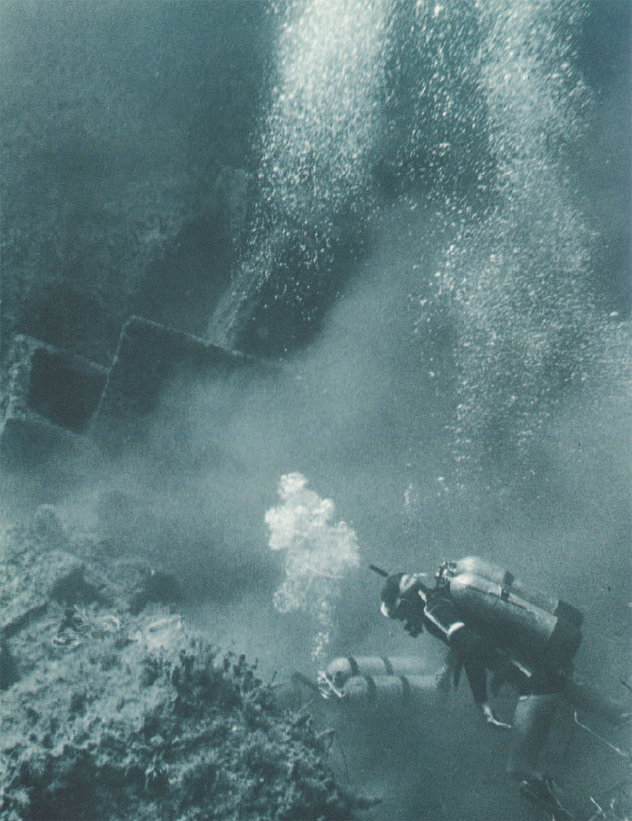
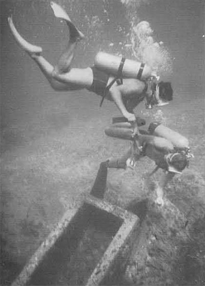
Upon arriving at Methone, we established our headquarters in a lean-to beside the crumbling and picturesque walls of the castle, and then contacted local fishermen. Before the end of the day we found ourselves swimming among heaps of columns in thirty feet of water off Cape Spitha. There was no question about their coming from a shipwreck; they were scattered over a twenty by thirty meter area which at its nearest point was ten meters from the cape and more than forty meters at the outside edge of the mass. We saw no evidence of any building having been erected on the rocky point nearby. In one place, the column pieces lay close together and were apparently in about the same position as they had been when stacked on the deck of the unfortunate ship that had carried them. Other pieces had evidently been rolled by heavy seas until they became wedged between outcroppings of rock.
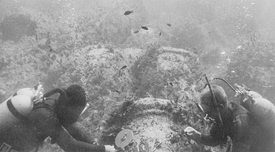
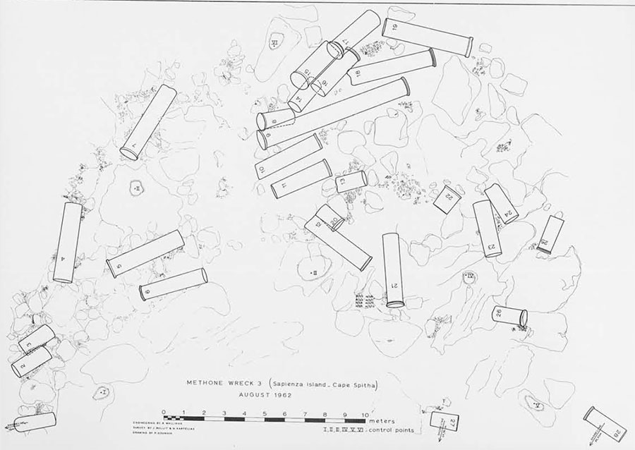
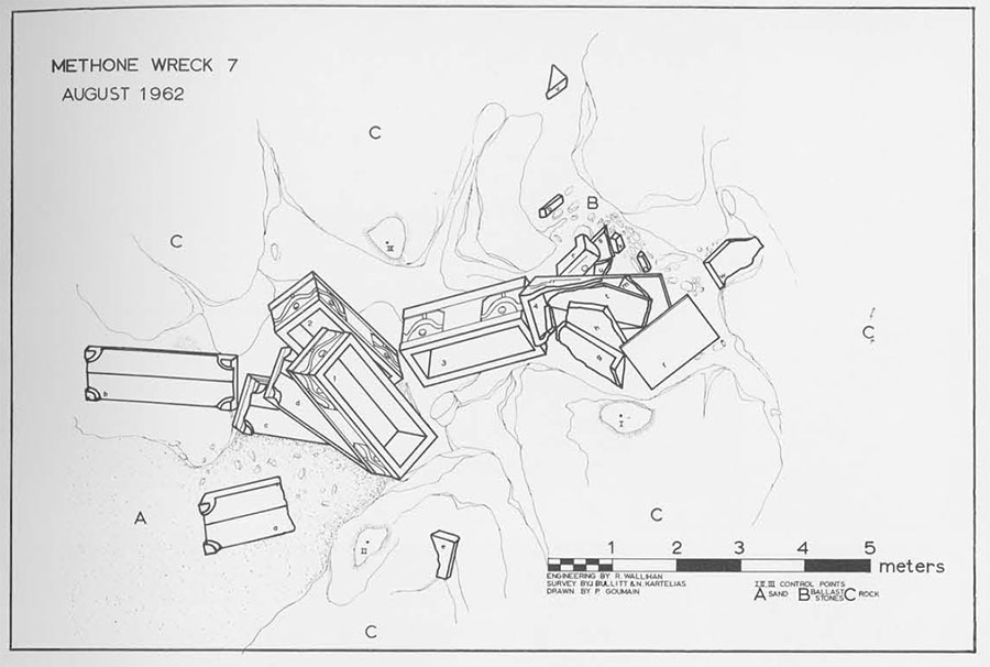
We initially counted nineteen fragments and one complete column but in subsequent dives we discovered eight more pieces hidden beneath a heavy growth of seaweed and hardly distinguishable from the neighboring rocks. We decided that the only practicable way of recording and studying the site was by drawing a carefully measured plan. The area was too large to be encompassed by a single photograph, and, because of distortion under water, a mosaic photograph would have been inaccurate. There were peculiarities in the length and shapes of the columns which could be understood only by studying a plan based on precise measurements.
But to make a plan of so large an area amidst limited visibility and heavy interference from current and surge presented us with a novel and challenging problem. Our time and funds were limited; we were not equipped with surveying instruments specifically adapted to underwater work; and we had no precedents to guide us. Because of the area’s extent we could not use a drafting frame like the one built at Yassi Ada in Turkey by George Bass.
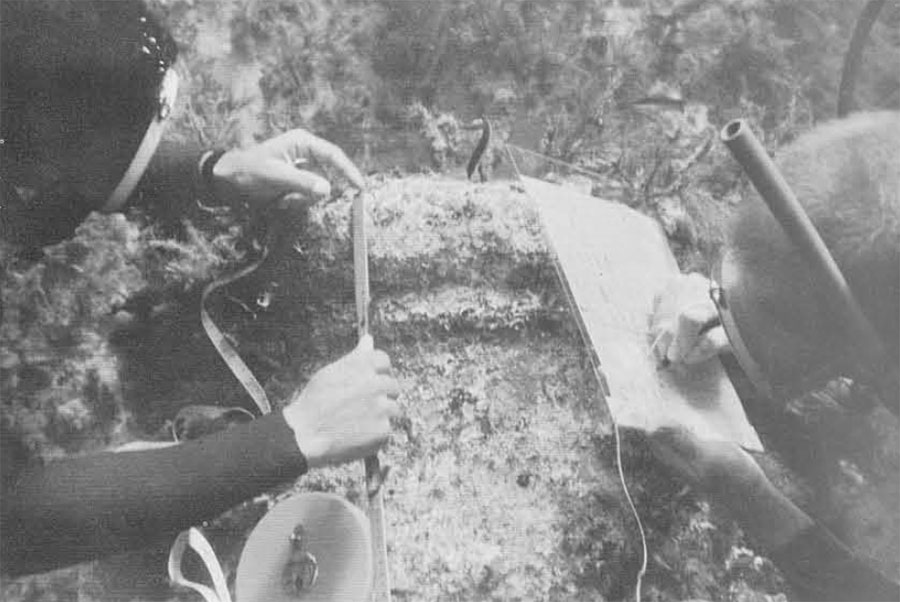
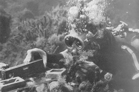
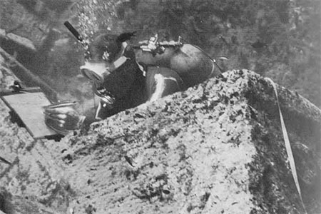
We considered various possibilities. Finally, our surveyor, Mr. Wallihan, a professional civil engineer on leave from the U.S. Army Corps of Engineers, decided that a tape survey of the kind sometimes undertaken on land would be a practical solution and would yield an accuracy comparable to that of land surveys. We improvised the necessary instruments from a carpenter’s level purchased at the village hardware store, a sheet of plexiglass, half a dozen lead diving weights, and a roll of plastic measuring tape. We cleaned the sea growth from the top of each column and fastened a numbered tag to it. Having selected six control points from the surrounding rocks we then triangulated each end of the columns from these points and carefully measured the length and diameter of each column. As a check upon our accuracy, an overlay photograph consisting of more than one hundred vertical photographs was shot and assembled. We recorded over fourteen hundred measurements before we were satisfied with the accuracy of our survey; Mr. Goumain then completed the final drawing.
Before we finished the survey of the column wreck we discovered six more scattered column fragments some sixty meters to the south of the main site. We found these to be of the same diameter and of the same kind of granite as the columns in the main group. Unquestionably, they belonged to the same cargo, but the pieces are small and so far removed from the central mass that we did not include them on our plan.
When we compared the samples of granite we had chipped off the broken edges of several of the columns with the granite of the Bembo monument we found them to be the same; the measurements were also similar. Geologists inform us that granite of this kind does not exist naturally anywhere in the Peloponnesus and that it probably does not come from Greece at all but from near Aswan, Egypt. If it is Greek granite, it can only come from Xanthe or Cavalla in the north, or form the island of Mykonos, a long way from Methone.
Study of the plan indicates that the columns are from a ruined building and are not part of a shipment from a quarry to a building site. All of the columns but one are broken. The unbroken column, no. 9, is eight meters long and weighs over fifteen metric tons. Column no. 1 and several others have rounded ends as if they had been used as bollards on a pier. All of the broken columns have irregular breaks and were probably broken when a building fell or was torn down. It is tempting to suppose that they broke when they rolled to the bottom as the ship disintegrated, but a close examination of the measurements shows this to have been impossible. The fragments cannot be fitted together.
For example, the fragments lying beside column no. 9 seem to belong together. No. 17, with its double astragal, is certainly the upper end of a column like no. 9, and it seems at first glance to fit onto no. 19 which, with its single astragal, must be the bottom half of a column. Their combined lengths, however, measure only 7.50 meters, some 50 centimeters short of the length of no. 9. All of the other “obvious” reconstructions fall in the same way. It is unlikely that a group of columns having approximately the same diameter should vary so much in length. Accordingly, it seems certain that these fragments are parts of sixteen, and possibly more, columns and that the missing parts were not in the same cargo as the group we have surveyed.
The measurements make it possible to calculate the weight of the cargo and to give an interesting indication of the carrying capacity of the ship. The main group weighs 122.95 metric tons, and the combined weight of the columns in both groups is 131.50 metric tons. This is well within the carrying capacity of a large modern caique from 30 to 40 meters long, a ship slightly larger than the amphora carrier now being excavated by George Bass at Yassi Ada.
It is unfortunate that, unlike the wreck at Yassi Ada, nothing of the ship’s hull remains. The wooden parts of the hull must have been smashed and washed away by wave action soon after the ship sank. All that remains of other cargo are a few potsherds which have been washed into clefts of the rocks among which the columns lie. A series of handles from about ten identical jars was raised. They are late Roman in character and are similar to pottery found in a wreck carrying a similar cargo of architectural elements discovered and investigated by Piero Gargallo and Gerhard Kapitan in Sicily. A careful search with metal detectors in the wreck area might reveal additional material with which to date the wreck more exactly and perhaps solve the mystery of who was freighting a cargo of pink granite columns, where they came from, and what was their destination.
The column wreck was only one of many ships that ended their careers on the rocks of Cape Spitha. Our fishermen friends told us of other locations along the east coast of Sapienza where one might find the cargoes of ships which had struck the Cape in a north wind, been damaged, and then foundered farther down the coast. A mile south of the Cape, trawler captain Lucas Masarello had found many amphoras in his nets after trawling over a muddy bottom, 30 meters deep and several hundred meters off shore. His report interested us because wrecks on a muddy bottom at that depth are usually well preserved. We dove at the place indicated and found scattered jars and what seemed to be ballast stones which probably came from a ship that has disappeared under the mud. The jars are mediaeval. When we had raised two jars and were convinced they were of the same date, we left the site because we lacked the equipment necessary for locating the wreck under its protecting blanket of mud. A mediaeval wreck could be of great interest since none has been recorded.
A search down the west coast of the island brought to light dozens of amphora necks, the earliest dating from the third century B.C., several of the Roman period, and many of late Roman or Byzantine times. A wreck which might be worth investigating in the future is badly broken up in shallow water and is probably Hellenistic or earlier. But our most interesting discovery at Methone was made when diver Kartelias went fishing one evening south of the column wreck site and found a heap of granite garland sarcophagi several hundred yards offshore.
There are four of them heaped in a gully in the rocky bottom. One is badly broken, perhaps by the shock as the ship struck, but all of its constituent pieces appear to be tougher. Their lids lie under them in a heap except for one broken lid half of which lies a few feet away from the main mass. A small pile of waterworn stones from some distant river bed fills the upper part of the gully. These ballast stones, typical of shipwreck sites, are good evidence that the sarcophagi are from a wrecked ship of which the timbers have been eaten by seaworms and destroyed by wave action. Mixed with the ballast stones are fragments of broken pottery and the roof tiles which are almost always associated with Roman Period shipwreck sites. A Roman glass unguent jar which can be assigned to the second or third century A.D. dates the wreck.
The sarcophagi are evidently unfinished, as the garlands are only roughed out. On each side, between the two garland designs, an unmarked space appears intended for an inscription, but none is inscribed. It is known that sarcophagi were often roughed out and shipped off to be finished at their destination, but this is the first find of the actual wreck of a ship carrying such cargo.
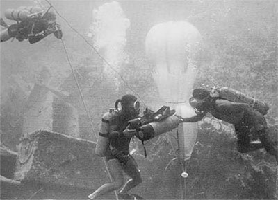
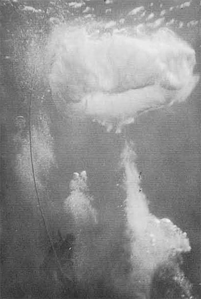
The sarcophagi were drawn in place following the same procedures we had used on the column wreck. When the drawing was finished we attempted to lift the half lid, which lay in the sand at the deepest end of the wreck, in the hope of finding more dating material or fragments of the hull preserved in the sand underneath. We calculated that the piece of granite weighed about one ton; our largest lifting device, a plastic balloon which could be inflated with air underwater from a diver’s mouthpiece or an extra air bottle, was designed to lift only five hundred pounds. But when we had attached this deflated balloon to the lid and began to fill it with air the lid slowly and ponderously rose with one end resting on the bottom. In the hope of adding the few additional pounds of lift that were needed in order to move the lid quite out of the way we squirted into the balloon a little extra air. The strain was too great for the “shroud lines” of the balloon; they broke all at once with an earsplitting shock. The balloon soared to the surface and its airy contents swiftly expanded into an awesome, mushroom shaped cloud of silver bubbles. Fortunately, no one was hurt either by the lid, which fell off to one side, or by the balloon which might have carried an unwary diver so rapidly to the surface as to rupture his lungs. Unfortunately, the sand on which the lid had rested revealed no further materials.
In addition to making the two surveys and examining the mediaeval and Hellenistic sites, the expedition searched several other underwater areas near Methone. Hundreds of amphoras and other pottery of various dates, but mostly Roman and Byzantine, were found in the harbor where we also discovered traces of the Turkish ships sunk by Admiral Miauris during the Greek revolution of 1825, In the channel between Megalo Sakuli Island and the mainland, two miles north of Methone, we found what appears to have been a Roman fleet anchorage of the first and second centuries B.C. Just before leaving Sapienza Island for the last time, we found what could be material from the H.M.S. Columbine, a 22-gun British warship which went ashore on Sapienza in the early nineteenth century.
All materials raised were drawn, photographed, and then deposited in the museum at Pylos.