- Tomb of the wealthy woman or queen as found. Bronze bowls with strainer and juglet at upper left; bronze tripod at top center; ivory cosmetic bottle to the right of the head; electrum breastplates and toggle pins at the right of the neck; beads lie at the left shoulder.
- Bronze bowl with smaller bowl, strainer and juglet as they were found fused together in the woman’s tomb.
- Bronze tripod with remnant of a dish riveted to the three prongs at the top. Below the rim at the top are holes which once held pendants.
- Carnelian beads found in the woman’s tomb.
- The large cauldron of hammered bronze as found in the woman’s tomb.
- (top) A bronze sword, one-and-a-half feet long, found in the bitumen tomb of a warrior. (left) A decorated cosmetic palette of stone. Eyepaint was ground in center depression with a pestle. (right) Cloth of the 12th century B.C. preserved in the bitumen in which the bones of the warrior were encased.
- A cosmetic box of ivory with sliding lid (top) and two ivory bottles (below) which probably once contained perfumed oil.
- Loom weights of clay as found in the line where they fell from the horizontal beam of the loom.
- (top) Two electrum toggle pins decorated with a herringbone design and other incisions. (left) Two electrum breastplates fused together. Two links of the chain by which they were suspended from the neck can be seen at the top. (right) Gold beads which served as spacers for the carnelian beads.
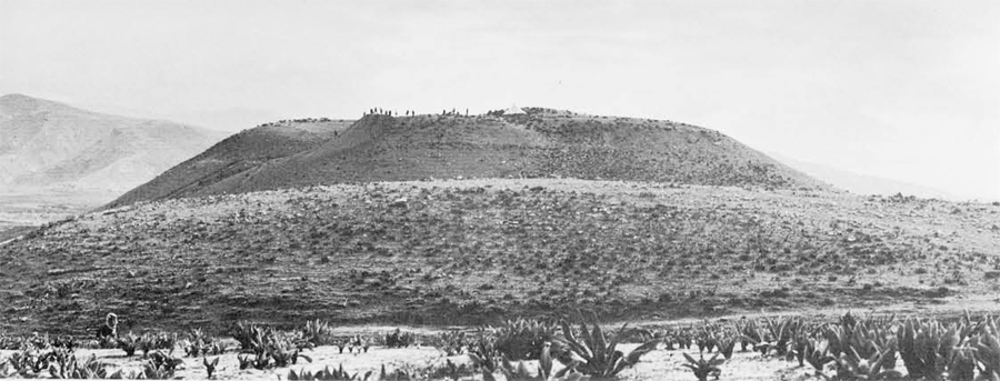
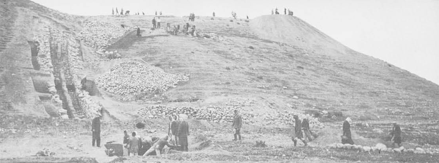
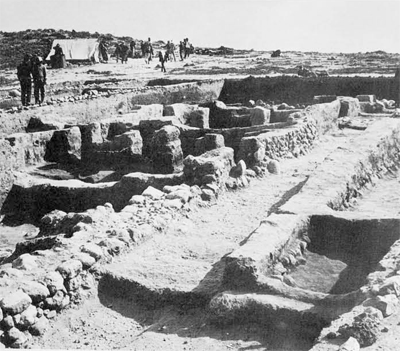
The cutting of the first trench into any large antiquity site is bound to be significant, especially if the mound lies in an area which is unknown archaeologically. Our first two months of digging at the virgin site of Tell es-Sa’idiyeh were not only productive of valuable information about the culture and history of the little-known Jordan Valley but they produced two major surprises: a monumental stairway from the city to the spring and the richest tomb yet discovered in Palestine. Shortly after Christmas I arrived in Jerusalem with the intention of beginning work at Tell es-Sa’idiyeh on January 1, 1964. Although most of the arrangements, such as obtaining a license from the government, arranging for a survey of the mound, the loan of equipment, and collecting a staff, had been made by correspondence, there remained the problem of finding lodging for a staff of twelve. Happily this last important arrangement was made quickly with the help of Asia G. Halaby, our cataloguer, who discovered a camp at Wadi el-Yabis, only ten miles from Telles-Sa’idiyeh, that had been recently vacated by the Italian engineers of the East Ghor Canal project. We drove immediately to the camp, where Mr. A. L. Zawati, the manager, made available for us such amenities as furnished bedrooms, an electric generator, hot and cold water, a dining room, and an excellent cook. With such a convenient and comfortable base of operations other arrangements could be worked out quickly. Father John E. Huesman, S.J., with the experience gleaned during two campaigns at el-Jib and assisted by Thomas L. McClellan, took over the job of procuring supplies. Laborers were recruited from the Arab village of Kureiyma, a mile to the east of the tell. Gustav A. Materna, our architect, with the help of Terry Ball, staked out five-meter plots according to grid lines on the contour map made by Subhi Muhtadi before our arrival. Usually the Department of Antiquities of Jordan supplies an inspector, who in addition to his official duties acts as a field supervisor. This season, however, Dr. Awni Dajani, director of the Department, when he heard of our shortage of personnel, generously sent not only the official inspector, Moawiyah M. Ibrahim, but also three members of the Department staff: Ahmed Shistawi, Hassan Mamlouk, and Khair Nimer Yassin. In addition to these members of the staff we had the help of Jacques Lagarce, of the French School of Archaeology, and of Robert H. Smith, who was with us for the second month. Work began promptly on January 1st as we had planned. The labor force of 60 with which we began grew quickly to 130 men. Two clues led to the discovery of the secret tunnel just below the surface of the north slope of the tell. One was a copious spring gushing out of the ground about 100 yards from the base of the mound, which must have been the principal source of water for the walled city in each period of its life. The other was a segment of two stone walls faintly visible on the surface of the north slope of the tell, which we guessed might belong to a passageway from the city to the spring. To test our guess we cut a trench across the line of the two parallel walls about half way down the slope. We learned after only a few days of digging that they were in fact the sides of a well-built stairway which measured about six feet in width. To follow these steps in the direction of the spring required little planning but a considerable amount of labor. By hiring as many additional men as we could possibly supervise in this section and working them six days a week, we succeeded in clearing 84 steps by the end of the season on February 29th. It remains to be seen how many steps there are and where they end.
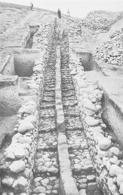
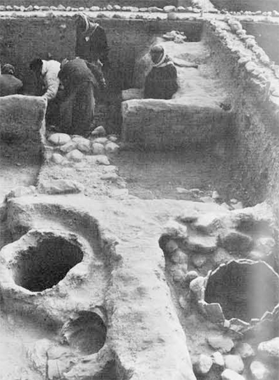
The most distinctive feature of the stairway with stone walls and paved steps is a mud-brick wall in the middle which divides it into two equal passageways. This wall served a double purpose: it supported the wooden beams of the roof of the tunnel and separated the flow of traffic up and down the stairs. One side–we are not yet certain which side it was-was for use in descending to the spring; by the steps of the other side, women with jars of water on their heads could walk up and be certain that their balance would not be upset by the traffic moving in the opposite direction.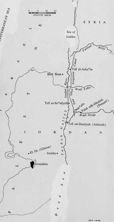 By making several deep probes into the hill outside the two walls of the stairs we were able to learn how the stairway had been built and to get evidence for the date of its construction. A deep trench had first been cut into the north slope of the tell; the sides of this trench were then lined with stones to form the walls of the tunnel and the steps were built into the floor of the trench. In the upper reaches of the stairs the treads are narrow, but toward the bottom the steps become a series of platforms measuring from four to five feet deep. The entire structure was roofed over with wooden beams supported by a central mud- brick wall. Reed and mud completed the roof for the tunnel, so that the entire passageway to the spring was camouflaged. An enemy would not only have had to discover the line of the secret tunnel to the vital water supply but would have had to cut through the roof in order to destroy access to it. The building of this defensive measure was contemporary with or later than the latest pottery that had washed down the sides of the tell and had become imbedded in the debris through which the ditch for the tunnel had been cut. Since the pottery sequence found in our test pits outside the walls of the stairway came to an abrupt end about 1200 B.C., and since the pottery washed down with the debris that filled the tunnel itself was not later than about 900 B.C., we judge that the tunnel was built and used within the span from 1200 to 900 B.C., or within the Iron I Age. The city for which the secret tunnel afforded a measure of security lies on top of the higher of the two levels of Tell es-Sa’idiyeh. The walled area covered approximately five acres. During two months of work we excavated only about one-twentieth of this area downward through two strata. The later (uppermost) stratum was preserved only to the extent of a few walls and circular pits for the storage of grain, some of which remained in crevices. Below this city level there were the remains of a half dozen houses and two streets of the fortified city that stood on the mound in the 10th century B.C. Thanks to a general conflagration, floors, streets, ovens, and charred beams which had supported the mud roof laid over reeds had been sealed by a thick layer of ash when the city was destroyed. The most interesting feature of this well-preserved city of the 10th century is the clear evidence for careful city planning. Two straight streets were uncovered, one parallel to the other. Along the east side of the western street are three houses almost identical in size and general plan. Each has a large front room, containing columns to support the roof, and a smaller room at the back. In one house the columns had been of wood; in the other two they are of mud brick. Although the houses were obviously a part of a general city plan, differences in the details of decoration and repair suggest private ownership. For example, the owner of one house had faced the mud-brick wall along the street with pebbles to protect its vulnerable surface from the hazards of city traffic. His neighbor had obviously not bothered to take similar precautions.
To the west of these houses there was a large cooking area in which there were five ovens for baking bread. Broken cooking pots, sheep bones, and a deep layer of wood ash made certain the identification of this sector of the city as a kind of communal kitchen. One of the buildings with columns seems to have been used for weaving. Seventy-two loom weights were found on the floor; some of them lay in the straight line in which they had fallen from the threads which had been attached to a horizontal beam. Other documentation for the daily life of the 10th century B.C. was recovered in artifacts such as fibulae, cosmetic palettes, bowls, pilgrim flasks, cooking pots, figurines, spindle whorls, and storage jars for wine, oil, and grain.
Although we did not penetrate generally the floors of this housing area on the top of the mound, we did discover in a trial trench at the north of the tell remains of the Iron I, Late Bronze, and Early Bronze periods in thirteen feet of the debris. It was obvious from this trench that the Bronze Age cities had been the largest in area and that the walled area had become progressively smaller in the course of time. The discovery of the Iron I Age cemetery was made by chance. One of the major objectives of the first season had been the cutting of a test pit into the lower level, or bench, of the tell. Since the surface was strewn with pottery of the Early Bronze Age, we were anxious to determine what the city of this period was like and what settlements there had been prior to the beginning of the Early Bronze period at about 3000 B.C. This project came to a halt suddenly when we discovered that in this very area there had been an extensive cemetery in the Late Bronze and Iron I periods. Fifteen tombs were excavated during the season, but two proved to be noteworthy, one because of a completely unique burial practice, the other because of the extraordinary wealth of its owner.
The strange burial was apparently that of a warrior, since the grave goods included a long bronze sword, along with the more usual pottery jars and bronze vessels. The sword is a cubit in length (one and a half feet), decorated on both sides of its blade and equipped with a handle of cast bronze and a pommel of bronze. The form is hitherto unknown in Palestine, but is documented by a very good example from Ras Shamra in the north of Syria. After the flesh had disintegrated from the bones they had been wrapped in cloth and covered with bitumen. The jars found in the tomb suggest a date somewhere around 1200 B.C. for this unusual burial practice. The woman’s tomb was built of mud brick and contained grave goods of ivory, pottery, gold, electrum, and carnelian. The poorly preserved skeleton was found lying with its head to the west and the feet to the east-the usual orientation of the burials within the cemetery. She had worn strings of carnelian, ivory, and gold beads-573 were recovered and counted. When the beads found near the neck of the skeleton were restrung the string measured over eleven feet in length. Adhering to a vertebra of her neck was a portion of a chain of electrum which had supported two plates of the same metal decorated with a her- ringbone design. Her dress had been held together by two electrum toggle pins, also decorated with the herringbone pattern.
The grave goods in the tomb were varied and displayed rare skill in workmanship. In addition to five pottery vessels, which are tentatively dated to about 1200 B.C., there were three ivory cos- metic containers, an ivory dish decorated with rosettes and a bull’s head, and an ivory spoon in the form of a human body fitted with a carved head in the round which was inserted in a socket of the spoon. These cosmetic containers had been arranged neatly around the head and shoulders of the body. The most distinctive contents of the tomb are seven examples of bronze work. The largest is a cauldron of hammered bronze with two handles riveted to the body. A tripod of Cypriote design supported a bowl riveted to the stand. The best preserved were a group, all of cast bronze: within a large bowl with two handles firmly attached by twelve rivets were a smaller bowl, a strainer with handle, and a juglet. Light had been provided in the tomb by a bronze lamp, a bowl pinched at the rim to make a nozzle for holding the wick. The site of Tell es-Sa’idiyeh has been tentatively identified by Nelson Glueck with the biblical Zarethan. One of the traditions preserved in the Bible about this city is that found in I Kings 7:45-46: “Now the pots, the shovels, and the basins, all these vessels in the house of the Lord, which Hiram made for King Solomon, were of burnished bronze. In the plain of the Jordan the king cast them, in the clay ground between Succoth and Zarethan.” The presence of so much cast bronze in the 12th century tombs at Tell es-Saidiyeh provides an added argument for the identification proposed by Glueck. More important than the actual wealth of these two tombs-the woman’s tomb is by far the richest burial yet found in Palestine-is the evidence for the cosmopolitan character of the culture of the city. The various artifacts point to lines of trade extending all the way to Syria and Cyprus and possibly to Egypt in the south.


