Navigational Chart
67-11-1
From: Ebon | Marshall Islands
Curatorial Section: Oceanian
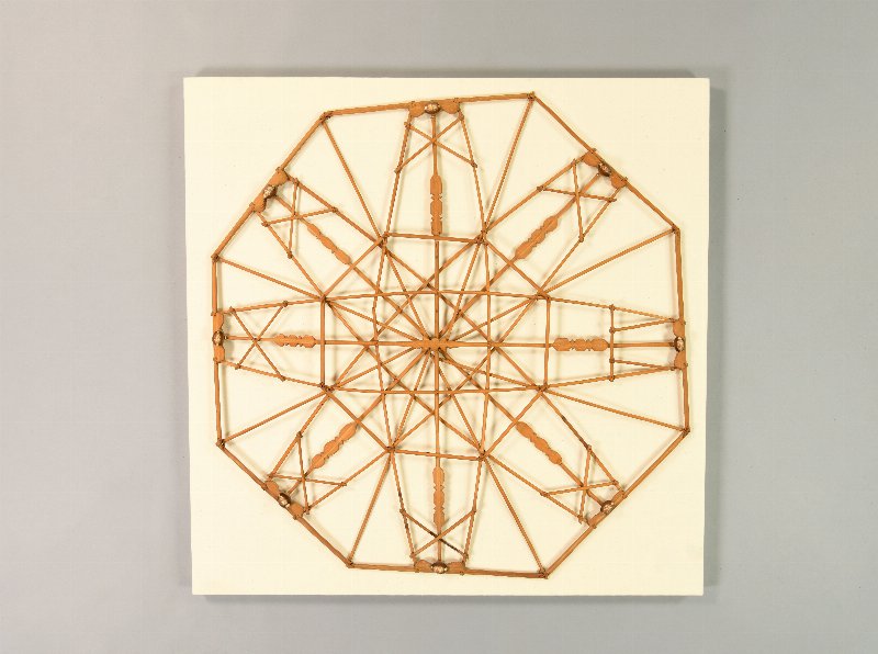

| Native Name | Mattang |
| Object Number | 67-11-1 |
| Current Location | Collections Storage |
| Provenience | Ebon | Marshall Islands |
| Date Made | Before 1958 |
| Section | Oceanian |
| Materials | Wood | Shell |
| Description | For generations, sailors in the Marshall Islands have observed patterns of ocean swells after they are deflected around islands in the group as navigational guides for confirming the location of islands that are out of sight over the horizon. For teaching aids to use when instructing apprentice navigators they have devised two kinds of wooden “stick charts.” One type (meddo) includes representations not only of ocean swells but also the islands of the Marshalls chain. The Museum has a fine old chart of this type, collected by Robert Louis Stevenson in 1890 (P3297). The other type (mattang) is a schematic, generalized representation of ocean swells as they are affected by encounters with islands. This chart, created by a Marshallese navigator in 1958, is a mattang, in which refracted swell patterns are represented by four pairs of opposed curved sticks. |
| Length | 92 cm |
| Width | 89 cm |
| Credit Line | Purchased from William Davenport, 1967 |
Report problems and issues to digitalmedia@pennmuseum.org.