Search Collections
- Object[489]
- no[489]
- american[489]
- adams mills[1]
- albany county[4]
- albany region[4]
- allegheny county (pennsylvania)[1]
- arenac county[1]
- assamoosic[1]
- auglaize county[1]
- barnes mound[1]
- berks county[10]
- bethlehem (pennsylvania)[1]
- big timber creek[1]
- blackwater swamp[1]
- brownsville[18]
- bucks county[6]
- burlington county[1]
- cedar bay[6]
- charlestown township[1]
- chattanooga[1]
- chester county[3]
- chickies[1]
- chillicothe[11]
- cincinnati[1]
- diamond (ohio)[13]
- duke (north carolina)[2]
- east orland[11]
- east saginaw[1]
- east tennessee[15]
- eastern pennsylvania[5]
- eastern united states[2]
- evansville[1]
- evesham township[1]
- ewing and bragdon site[23]
- farm of william holocher[4]
- fayette county (pennsylvania)[18]
- fort duquesne[1]
- french creek[1]
- frenchman's bay[23]
- german swamp[1]
- gloucester county[1]
- hamilton county[1]
- hamilton county (ohio)[1]
- hancock county (maine)[34]
- hans hoch's fields[2]
- huron county[1]
- illinois[3]
- indiana[9]
- jersey county[1]
- kentucky[3]
- kimberton region[1]
- knox county (tennessee)[1]
- knoxville[1]
- lancaster[1]
- lancaster county (pennsylvania)[5]
- larger van meter mound[1]
- lebanon[1]
- lehigh county[5]
- lehigh river[1]
- locust grove[2]
- macoupin county[1]
- maine[34]
- marlton[1]
- marseilles[1]
- marshall county[48]
- marshall county (west virginia)[35]
- maryland[1]
- massac county[1]
- meigs county (ohio)[2]
- mercer county[4]
- miami county (ohio)[11]
- michigan[9]
- monongahela river[18]
- monroe county (pennsylvania)[1]
- morrisville[4]
- mount de chantal convent[5]
- near wheeling[3]
- new jersey[16]
- new york[4]
- north carolina[2]
- ohio[157]
- ohio county[48]
- ohio county (west virginia)[40]
- ohio river valley[11]
- palmyra township[13]
- pennsylvania[119]
- pike county (ohio)[2]
- port washington[6]
- portage county[34]
- pricetown[9]
- richland county[2]
- ross county[14]
- shelby[2]
- smith county[6]
- sullivan county (indiana)[7]
- tennessee[17]
- trenton[4]
- united states of america[432]
- unites states of america[34]
- west virginia[88]
- wheeling[40]
- wisconsin[7]
- late archaic[11]
- maritime archaic[11]
- moorehead phase[11]
- algonguin[1]
- red paint people[11]
- 10 1/2" deep below 6 1/2" of ploughed area[1]
- 11" deep, 8" down in cr. shell[1]
- 11" from b.[1]
- 13 1/2" deep, in cr. shell and fire dirt;[1]
- 13" down in 16" band of shell over fire pit[1]
- 14" deep, heap 28" deep; 25" from c, 27" from 3[1]
- 14" from 7, 15" from c.[1]
- 15 1/2 from 7[1]
- 15" deep in cr. shell[1]
- 16 1/2" deep on top of ash and beach gravel and fine shell 5" deep[1]
- 16 1/2" from c, 19" from 1.[1]
- 16" from 3, 33 1/2" from c.[1]
- 17" deep in humus, beach gravel and fire dirt and shell, on top of basic clay[1]
- 17" deep, under ploughed area[1]
- 17" from d, 2" from 6[1]
- 18 1/4" from c.[1]
- 2 1/2" from 2[1]
- 2" from b, 13" from 4[1]
- 20" from c, 4 1/4" from 4[1]
- 21" down in 16" band of shell over fire pit[1]
- 22" deep in 1" of beach pebble below 2" of black ash at bottom of heap[1]
- 22" deep, under 17" of cr. shell, and 1" of b. gravel, in 1 1/2" of fine cr. shell and fire dirt[1]
- 22" from b, 6" from 6[1]
- 23" from c, 2 1/2" from 3.[1]
- 24" deep in bottom of cr. shell extending from top[1]
- 24" deep in whole and cr. shell 28" deep[1]
- 25" deep lying in fire dirt of hearth, beside hearth stone under 2" of pebble[1]
- 27 1/2" deep in 1 3/4" of beach gravel.[1]
- 27" deep below 2" stratum of beach gravel, in bl. fire dirt[1]
- 27" deep, heap 32" deep here over band of cr. shell[1]
- 3" deep over fire dirt 3 3/4" deep; 7" from 2, 14" from a.[1]
- 4 1/2" from b[1]
- 5 3/4" deep in bottom layer of beach gravel and shell[1]
- 5" from 3, 30" from b[1]
- 6" deep in whole and cr. shell; 1" from c. 16 1/2" from 1[1]
- 8" from 7[1]
- `3" deep. 2" down in 16" of whole and cr. shell; 17" from b, 6" from 10[1]
- above fire dirt and beach gravel, heap 31" deep;[1]
- flying moose lodge boys camp (est. 1921)[11]
- from brandywine (laubach) camp-site.[2]
- from roadside gutter[1]
- from rock shelter[1]
- heap 28 1/2" deep[1]
- heap 28"[1]
- jim armstrong farm[1]
- just above humus; 11" from 14, 26 1/2" from c.[1]
- on 15, 23" from b[1]
- on c line, 5 1/2" from 3.[1]
- on line o, 21" from 15.[1]
- rowland's farm[1]
- shores of delaware river at morrisville, pa., and trenton, n.j.[4]
- surface find[5]
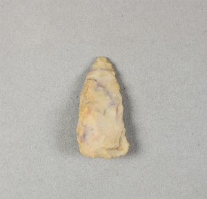
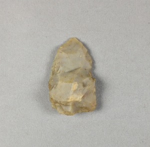
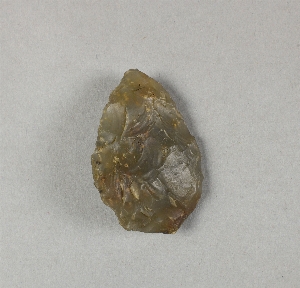
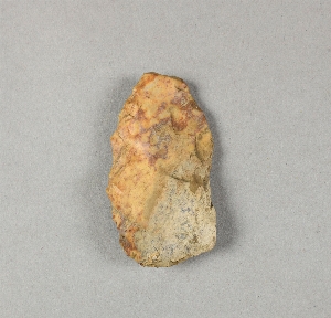
- chipped[232]
- actual citation[14]
1 - 30 of 489 Records
1 - 30 of 489 Records