Search Collections
- Object[4,045]
- no[4,045]
- american[4,045]
- adze[23]
- adze blade[36]
- adze fragment[6]
- adze head[6]
- animal bone[14]
- antler[13]
- arrow[6]
- arrowhead[46]
- articulation[45]
- awl[229]
- awl point[13]
- bar[7]
- barb[11]
- barbed head[34]
- bead[82]
- bear bone[18]
- bear tooth[8]
- bird bone[26]
- blade[209]
- blade fragment[27]
- boat[9]
- bone[95]
- bone fragment[15]
- boulder chip[8]
- buckle[6]
- caribou bone[10]
- chip[41]
- chisel[27]
- copper fragment[10]
- dart head[52]
- dart point[12]
- drill[22]
- drill point[17]
- fish hook[59]
- flake[105]
- flint flaker[17]
- fragment[12]
- game stick[11]
- grinding stone[7]
- grooved stone[11]
- hammerstone[34]
- harpoon head[44]
- ice pick[6]
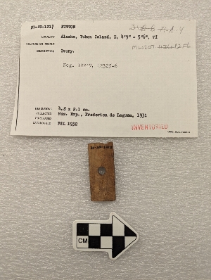
- ivory[6]
- knife[60]
- knife blade[10]
- labret[39]
- lamp[42]
- lance blade[33]
- lance point[6]
- mask part[10]
- matting[10]
- mirror[12]
- model[13]
- needle[77]
- nose pin[7]
- notched stone[41]
- object[41]
- paint stone[19]
- pebble[14]
- peg[14]
- pendant[39]
- pestle[6]
- pin[185]
- planing adze[7]
- planing adze blade[30]
- point[311]
- pottery fragment[35]
- pottery fragments[15]
- pumice[11]
- rib[16]
- ring[43]
- rod[21]
- rubbing tool[74]
- saw[36]
- scraper[65]
- scraper blade[13]
- shaft[11]
- sherd[16]
- sinker[228]
- slab[26]
- slate[21]
- slate fragment[39]
- socket piece[16]
- splinter[7]
- splitting adze[59]
- spoon[7]
- stone[68]
- throwing stone[15]
- tool[11]
- toy[18]
- tube[42]
- ulo[14]
- ulu blade[101]
- ulu blade fragment[10]
- ulu fragment[9]
- wedge[54]
- whale bone[9]
- whetstone[103]
- worked bone[12]
- adam's place[9]
- admiralty island[3]
- alaska[4,024]
- alaska college[3]
- anderson bay[7]
- angiartunit[4]
- angiluk[4]
- anvik[28]
- anvik point[30]
- anvik river[36]
- aurora (alaska)[14]
- aurora spit[13]
- axlatuliq[8]
- bainbridge island[4]
- bonasila[47]
- boswell bay[3]
- cape starichkof[4]
- chenega island[18]
- chenega village[5]
- chiktaruik[5]
- chilkoot lake[3]
- china poot bay[3]
- cook inlet[827]
- copper river[3]
- cordova[20]
- cottonwood creek (alaska)[5]
- cottonwood creek (alaska)[313]
- crescent river[6]
- daxatkanada[24]
- daxatkanada fort[346]
- diyaguna'et[23]
- east beach[5]
- eleven-mile village[7]
- ellamar[5]
- esther passage[10]
- evans island[3]
- ewan bay[10]
- fish creek[6]
- fish creek indian reserve[6]
- fox farm[118]
- frank fox's place[91]
- ghost creek[5]
- halibut cove[134]
- hawkins cut-off[8]
- hawkins island[454]
- hinchinbrook island[22]
- hologochaket[8]
- holy cross[96]
- indian island[4]
- innoko river[9]
- ishmailoff island[133]
- kachemak bay[706]
- kaiyuh slough[85]
- kaltag[5]
- kashim[17]
- kasitana bay[5]
- kateel[24]
- kenai[5]
- khotol river[85]
- kimiklik village[10]
- knakatnuk village[4]
- knight island[49]
- kootznahoo inlet[387]
- koyukuk river[25]
- kustatan/west foreland[7]
- long bay[5]
- lost river[23]
- lower yukon river valley[279]
- middle yukon valley[42]
- montague island[25]
- mummy island[8]
- north america[324]
- nunakchuk[8]
- nunivak island[11]
- old fish camp[66]
- old town[15]
- paddy bay[10]
- palu:tat[84]
- palugvik village[447]
- passage island[12]
- pillsbury point[29]
- port graham[35]
- prince william sound[584]
- qatlexelye[5]
- qeyagwik[8]
- qngaqesle island[10]
- refuge island[5]
- rock shelter[4]
- sheep bay[8]
- smith's fox farm[16]
- stockdale harbor[26]
- tanana (alaska)[11]
- tanana mission[10]
- tutka bay[5]
- united states of america[3,994]
- west beach[23]
- wunqra[11]
- yakutat bay[74]
- yukon island[1,934]
- yukon willow creek[11]
- athapaskan[18]
- chugach[53]
- chugach eskimo[5]
- denbigh flint complex[1]
- eskimo[1,062]
- eyak[12]
- hoonah[1]
- indian[19]
- inuit[16]
- kachemak bay[1]
- kachemak bay culture ii[1]
- kachemak bay culture iii[730]
- kachemak bay culture sub-iii[259]
- kachemak bay iii[1]
- kenai[1]
- knatana[7]
- kodiak[3]
- kuchin[1]
- lower yukon[2]
- modern indian[52]
- post russian[2]
- pre russian[1]
- prehistoric[1]
- prehistoric eskimo[1,983]
- prehistoric indian[50]
- prehistoric tlingit[3]
- prince william[3]
- taka tlingit[2]
- tanaina[10]
- tanana[2]
- tlingit[6]
- yakutat (culture)[42]
- yukon[26]
- arctic culture area[4,045]
- 1 k 11', under grinding stone and log in house corner, ii[13]
- 1st site on right lagoon[11]
- 2 d, 1' 6" - 2', vii or viii[9]
- 2 f 5' 6", iv -- all found within 6 inches of each other in dark, hearthy earth[12]
- 2 h[24]
- 2 j[21]
- 2' 6" - 3' 3"[13]
- 2nd site on right lagoon[10]
- 3 h[94]
- 3 j[46]
- 3 j, 1'3"-1'9"[8]
- 3 k[12]
- 3 x 5'[9]
- 3' - 3'6"[13]
- 3' 9" - 4' 4"[8]
- 3'3" - 3'9"[14]
- 3'6" - 4'[17]
- 3'9" - 4'3"[21]
- 4 h[62]
- 4 h, surface of old midden[8]
- 4 j[54]
- 4 j, 1'3" - 1'10"[8]
- 4 j, surface - 9"[9]
- 4 k[51]
- 4 k, 3'3" - 3'9"[43]
- 4' - 4'6"[20]
- 4'3" - 4'9"[14]
- 4'6" - 5'[9]
- 4'9" - 5'3"[19]
- 5 h[88]
- 5 j[56]
- 5 j, 10' 6" - 11', layer 1[15]
- 5 j, 11' 6" - 12', layer 1[8]
- 5 j, 12' 6" - 13', layer 1[8]
- 5 j, 13' - 13' 9", layer 1, bottom of midden[9]
- 5 k[28]
- 5 k, 12' - 12' 6", layer 1[8]
- 5' - 5'6"[16]
- 5'3" - 5'9"[11]
- 5'6" - 6'[20]
- 6' - 6'6"[11]
- 6'3" - 6'9"[16]
- 6'6" - 7'[54]
- 6'9" - 7'3"[11]
- 7' - 7'6"[19]
- 7'3" - 7'9"[15]
- 7'6" - 8'[13]
- 8' - 8'6"[16]
- 8'3" - 8'9"[9]
- 9' 6" - 10'[12]
- a, surface to 6", ix[9]
- a2e 6-12"[9]
- beach[48]
- beach.[11]
- c, 2' 3" - 2' 9", ix[13]
- c2e 12-18"[9]
- c2e 6-12"[13]
- cave in[11]
- d near surface[11]
- d2e 6-12"[10]
- f, 6' 6" - 7' 3", iii[12]
- h, 7' 3" - 7' 9", iii[9]
- house 12[29]
- house 33[13]
- house 6[10]
- house 8[22]
- j[11]
- j, 2'-2'6"[11]
- l, 3' - 3'6"[12]
- layer 5 a[11]
- layer 5 b[12]
- layer 5-a[27]
- layer 5-c[12]
- layer 5a[61]
- layer 5a?[9]
- layer 6[97]
- layer 6 (5a?)[9]
- layer 6 or 5-b?[9]
- layer 6 or 5-c[12]
- layer 6 or 5c[10]
- layer 6 or 7[35]
- layer 6?[30]
- layer 7[111]
- layer 7 or 8[12]
- layer 7 or 9[12]
- layer 7?[19]
- layer 8[93]
- layer 8, 7? or 6[17]
- layer 8?[16]
- layer 9[53]
- layer 9?[30]
- layers 8 and 9[10]
- m, 4' - 4' 6", layer 3 or 4[10]
- mound b, upper 10' in layer of fire-cracked rocks[10]
- on floor of house?[23]
- pit 3[9]
- point west of entrance to halibut cove[40]
- slope of terrace #2, at house #1[10]
- surface - 2' 6"[17]
- tailings[29]
- adze[3]
- agate[1]
- andesite[12]
- animal bone[36]
- animal skin[1]
- animal tooth[3]
- antler[295]
- argillite[1]
- augite granite[1]
- bark[4]
- basalt[39]
- bear bone[36]
- bear gutskin[1]
- bear tooth[14]
- beaver tooth[3]
- birch bark[9]
- birchbark[1]
- bird bone[273]
- black oil shale[3]
- bone[1,085]
- boulder (stone)[1]
- brass[1]
- canine tooth[1]
- caribou antler[1]
- caribou bone[24]
- caribou skin[1]
- ceramic[67]
- chalcedony[2]
- chert[57]
- china[1]
- clam shell[1]
- clay[11]
- claystone[9]
- coal[3]
- concretion[1]
- copper[27]
- cormorant bone[8]
- cotton[4]
- crane bone[1]
- deer bone[1]
- dentalium shell[1]
- diabase[7]
- diorite[9]
- dog bone[7]
- dolorite[31]
- eagle bone[1]
- feather[10]
- felsite[9]
- felspar porphyry[1]
- fish bone[42]
- flint[16]
- fur[4]
- glass[2]
- granite[5]
- grass[10]
- graywacke[9]
- greenstone[107]
- gypsum[4]
- hair[7]
- hematite[5]
- iron[10]
- ivory[79]
- jasper[19]
- lava stone[39]
- limestone[13]
- mammal bone[5]
- marble (stone)[19]
- metal[3]
- micaceous slatey schist[2]
- moose bone[3]
- mussel shell[2]
- obsidian[3]
- ochre[11]
- oil shale[2]
- paint[13]
- phyllite[2]
- pumice[11]
- quartz[10]
- quartzite[2]
- red shale[30]
- sandstone[138]
- schist[24]
- sea otter tooth[3]
- seal bone[36]
- seal tooth[3]
- shale[104]
- shell[12]
- sinew[13]
- skin[4]
- slate[645]
- soot[10]
- steatite[2]
- steel[3]
- stone[562]
- syenite[2]
- tooth[10]
- ulu[2]
- whale bone[59]
- wood[124]
- wythe[6]
1 - 32 of 4,045 Records
1 - 32 of 4,045 Records