(Mr. Giddings, who is associated with the University Museum during his year’s leave of absence from the University of Alaska faculty, describes the results of two field seasons of archaeological excavation on a rocky cape of the north Bering Sea coast. This project was sponsored by the Arctic Institute of North America, in cooperation with the Office of Naval Research. Students and graduates of the University of Alaska assisted in the research.)
The steep-walled, storm-beaten shores of Cape Denbigh, a basaltic peninsula jutting into the north Bering Sea, seem now in retrospect a logical place on which to look for camp sites of Early Man. During the summer of 1948, however, on our first motorboat trip beneath the bird cliffs of the cape, we thought only of investigating legendary villages known to the Eskimos of Shaktoolik.
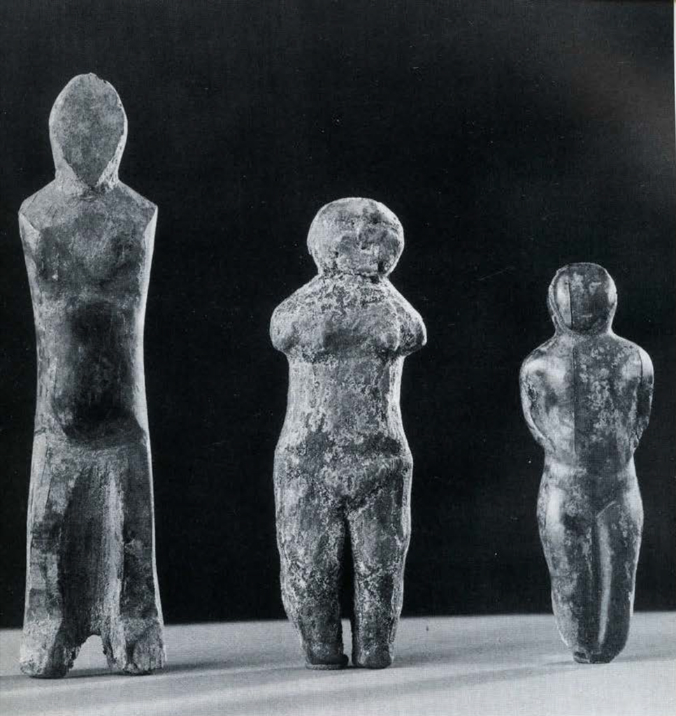
Museum Object Numbers: 56-28-1285
Image Number: 40501
The stories about those villages contain as many elements of the unreal as of the real. One tells of the daughter of the “chief,” or strong man, of a village known as Nukleet who had given birth to a male child. This child grew so big by the end of its first year that it one day devoured its mother, precipitating a panicky migration which left the village forever abandoned. The second legend deals with the incidents in the rise to power of a dwarf not more than two feet call, who held together two rival factions of a second village, called Iyatayet. This village also fell into ruins when its people moved away to the north. Both of these legends had been recorded through a multiplicity of episodes by Simon J. Newcomb, who had gone so far as to make sure that the sites actually existed at the places indicated by the stories. Mr. and Mrs. Newcomb, both graduates of the University of Alaska, where they had studied anthropology, were the teachers and government representatives at the Eskimo village of Shaktoolik during the years 1947 and 1948. They realized that the two sites, located in an area which had thus far escaped intensive archaeological investigation, might be important in in the piecing together of Eskimo prehistory.
On the strength of these reports from the Newcombs, our plans for an archaeological survey of the Norton Sound region were focussed on Cape Denbigh. The choice proved a very fortunate one, in that two years of excavation have taken us through most of the previously known Eskimo culture phases, and into a bottom layer that seems to have been laid down by some of the earliest migrants to cross the Bering Strait into the New World.

The first major archaeological excavation north of the Aleutian Islands was that made in 1917 at the Birnirk Site, near Point Barrow. This was carried out by W. B. Van Valin for the University Museum. Dr. J. Alden Mason, in describing the Birnirk material some years later, showed a direct relation between the Point Barrow developments and those of the early Thule Culture of north Canada and Greenland. Since the discovery of Birnirk, our knowledge of cultural developments along the Arctic Ocean and Bering Sea coasts has become well documented through the work of several archaeologists representing as many different institutions. Some of these are Henry B. Collins, Jr., of the Smithsonian Institution; Frederica de Laguna, of the University Museum; Diamond Jenness, of the Canadian National Museum; Otto Wm. Geist, of the University of Alaska; and Froelich G. Rainey, who then represented the University of Alaska and the American Museum of Natural History. The work of these pioneers in a relatively new field has shown that coastal people of the Arctic have been for perhaps two millennia completely at home under severe climatic conditions. It has also shown that their cultures have gradually lost the elaborate artistic forms characteristic of the earliest horizons.
Then, in 1939, a discovery was made at Point Hope that gave new impetus to Alaska archaeology. The uncovering that summer of the now famous Ipiutak site of houses and elaborate burials gave evidence that the American side of the Bering Strait had drawn heavily from the mainstreams of Asiatic culture in the time when the Maya were creating their large temples in Middle America. Since that time, all of us who work in the field have coordinated our efforts as closely as possible.
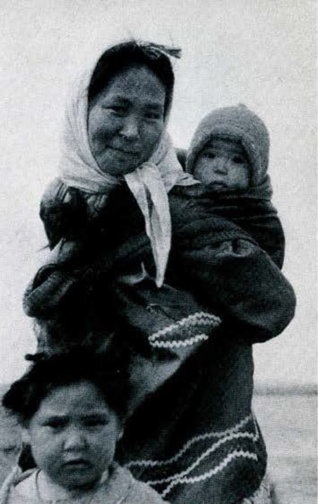
Image Number: 48702
The long-range plan under which the University of Alas ka has been cooperating with other institutions in archaeological research really began with that summer of 1939, when Dr. Rainey invited Helge Larsen, Curator in the Danish National Museum, to join him in a field season at Point Hope. I was included as a third member of the party. Since then, my own work has been directed to tree-ring dating and the archaeology of inland Eskimos of the Kobuk River, and most lately to sites in the north Bering Sea.
At Cape Denbigh, our principal aim in 1948 was to find out whether or not suitable sites for dating by the tree-ring method existed south of Seward Peninsula. My wife and year-old boy and I flew to Shaktoolik early in June, where we visited with the Newcombs and talked with the natives of the village. Lewis Nakarak, a Malemute-speaking Eskimo, took Mr. Newcomb and me in his boat the fifteen miles to the cape. Nukleet proved to be a rounded slope from forty to seventy feet above sea level, fronted by steep cliffs. The mound is covered by a heavy growth of bunch grass, in contrast to surrounding thickets of alder and poplar. House pits were nearly all leveled off, but test cuts down to the top of frost showed that the site was rich in pottery and organic leavings of the last occupants. What lay within the frozen ground could be determined only by slowly thawing and removing the contents of the mound.
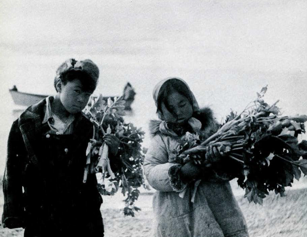
Image Number: 48703
Investigation of the other site took us seven miles to the north side of the cape, past cliffs three hundred feet high. The narrow ledges of these cliffs were crowded with swarms of nesting birds-murres, puffins and gulls. Small beaches appeared at intervals, but we saw no suitable place for a village to be built until we came to the little bay which Nakarak called Iyatayet. In contrast to Nukleet, this site boasted a small but permanent stream. The steep slopes on both sides of the mouth of the stream were covered by the characteristic coat of bunch grass which marks long-abandoned habitation sites. Elsewhere the slopes held a low jungle of alder and willow.
We found it difficult to sample Iyatayet so early in June. The solid tussocks out of which the new crop of bunch grass had not yet begun to grow were still frozen at center. In our tests at the grass roots, however, we noted that chips of flint often appeared. We had found none of these at Nukleet. This fact was to become more significant later in the summer.
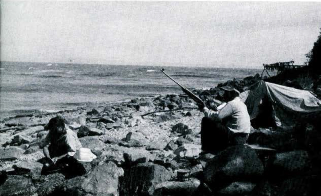
We decided on Nukleet as the more promising site upon which to take the time required for the slow thaw of a planned excavation. When camp was finally established on the narrow, rocky beach below the site we felt we had created a village of our own. Our four Eskimo helpers had brought their families, and tents blossomed on every flat part of the beach above high tide line. Fish racks were erected. Whitefish were plentiful, and the salmon season was not far away. Nukleet is a good sealing place, and the small white whales, or beluga, often forage just off the point. Before long, seal meat and whale skin were drying on the racks. Mrs. Nakarak and her friends showed my wife where to find the various edible wild plants-wild rhubarb and onions, sour greens, and a number of leaves and herbs that substitute well for spinach and lettuce. The berries ripened later in the summer.
We laid out four test areas, two of them forming a six-foot wide trench extending 180 feet from the upper edge of the mound to the cliff edge. Once stripped and cleaned to the cop of frost, these cuts could be taken down at the rate of daily chaw. Depending upon the sunshine and the nature of the deposit, this thaw varied from two to six inches a day.
By mid-July we had a picture of the people whose houses and refuse heaps made up Nukleet. Their houses had been rectangular and partly subterranean, with long entrance tunnels. The people had been primarily sealers and fishers, in the Eskimo tradition; yet they had been distinctive from other coast-dwelling Eskimos in having certain inland traits. Counts of animal bones in refuse heaps showed that they hunted caribou extensively. They also used birch bark vessels and beaver-tooth knives. Their pottery was typical coarse-tempered, very thick gray ware. Preservation of organic materials in this permanently frozen deposit was such that house timbers, antler objects, wooden arrow shafts, bone needles, grass mats, and even bits of skin clothing came out looking quite as fresh as though they had been discarded only a few days before. Miniature animal heads carved in ivory still had bits of quill decoration in small bored holes. Surprisingly, however, we had yet to find at Nukleet any of the flint chips like those from the tests at Iyatayet.

When we had reached a maximum depth of seven feet in one spot, and had begun to scrape bedrock in others, it became obvious that the flint at Iyatayet represented some development that we had not found at Nukleet. Consequently, we moved camp temporarily to the more remote site and began a series of test cuts.
The Eskimos were not averse to a move since the puffin and murre eggs which they had been gathering from the cliffs were now mostly hatched out. My wife was delighted also at the prospect of a stream of clear water in camp, so that all drinking and laundry water would not have to be carried down in buckets from tundra pools on top of the cliff. The women busied themselves at the new site gathering blueberries from the slopes. Each family wanted to fill at least one barrel for use during the coming winter.
The upper few feet of the deposits at Iyatayet were obviously related to those in which we had been digging at Nukleet. Scattered throughout these levels, on the other hand, were chips and artifacts of flinty materials such as we had not encountered at the first site. Some of the blades, points, and scrapers were of kinds known previously only from the Ipiutak site at Point Hope. A few were extremely small and delicate fragments of points of a sort we had not seen before. These were diagonally flaked on both faces with almost microscopic precision. The immediate explanation of these tiny objects was offered by Nakarak and his friend Sokpilak, who were of the opinion that the dwarf chief of the legend had made them.
A less romantic explanation offered itself when it was found that beneath the midden deposit containing organic material lay thawed clays enclosing mainly objects of stone. Apparently the more recent occupants of this dwelling site had dug their houses down into an older layer of culture, mixing the earlier artifacts into the upper layers. This culture level in the thawed clays had in it artifacts resembling those of the Point Hope Ipiutak culture. These included flints and other scone objects known from the more northerly site, but also new types, including a thin, hard, dentate-stamped form of pottery and triangular stone lamps. To have discovered an Ipiutak-like site in stratigraphy in this area was cause for excitement, and we dug late into dusk each day as the August sunlight grew briefer and the big storms of autumn threatened our camp.
Then, at the end of the season, an even more exciting picture unfolded. Below these Ipiutak-related levels lay laminated clays that held no trace of occupation, and under that was a thin layer of pebbles on top of bedrock containing what appears to be the earliest trace of man yet located on the Alaska coast.
I returned to Cape Denbigh last summer with Wendell Oswalt to dig both sites, concentrating on the old. Mr. Oswalt dug Nukleet under my supervision, and I continued at Iyatayet. A complete analysis of the tree-ring collections and the estimated 20,000 artifacts from both sites will require many months to complete. However, the significance of the bottom layer at Iyatayet can be summarized on a preliminary basis.
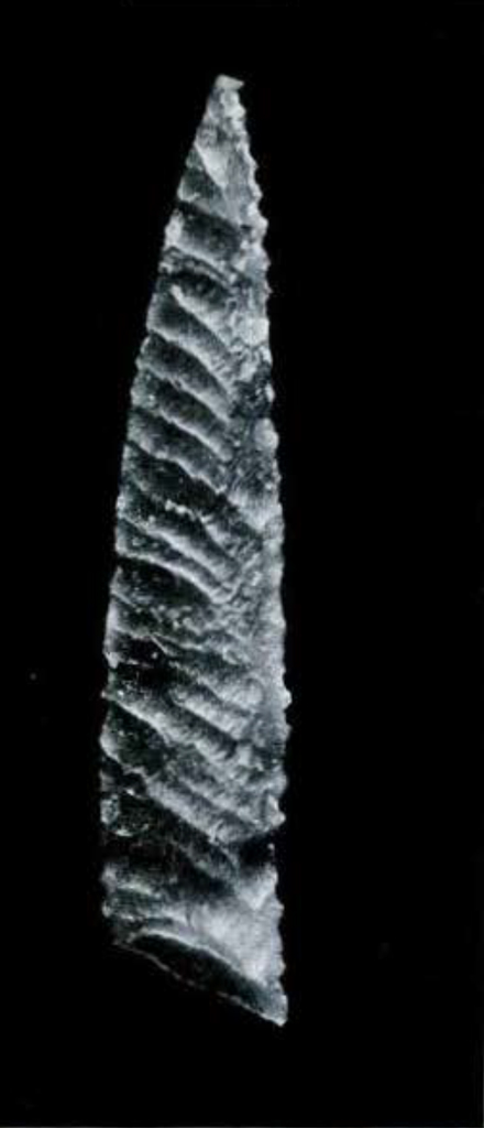
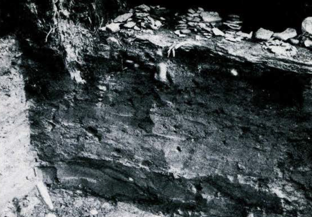
Image Number: 40512
The Microlithic Layer, as we now designate the pebbly stratum at the bottom of Iyataret Mound, has yielded to date nearly a thousand flints so small that nearly all of them fit comfortably into pillboxes. Most numerous among these are lamellar flakes (or microliths), flake knives and burins such as were once widely spread over the Old World. The burins and the needle-like spalls struck from them, appear to be unique in America, though they were characteristic of the Upper Palaeolithic period in Old World prehistory. Along with these are found a single fluted point of the Folsom type, a broken blade like the oblique Yumas, and other objects similar to those from the earliest known American horizons. Certain of the distinctive Folsom points and Yuma blades have been found associated with the bones of mammoth and other extinct animals in type sites of the southwestern United States. It is therefore of great interest that we find similar artifacts in the same level with Old World types in Alaska. The extremely fine flaking on some of the tiny derivatives of lamellar flakes does not appear at present to have an exact counterpart.
As to the dating of this oldest material, we can just now only guess. The Ipiutak-related layers above it, not to mention the span of time indicated by the still later organic layers, give us an estimated 2000 years as an upper limit. The fact that neither lamellar flaking, or the techniques of burin manufacture, nor the Folsom and Yuma types appear at Ipiutak, shows however, that we are dealing with a new phase in the archaeology of the far north, and that we shall have to go far afield on more than one continent to determine the place of this phase in the story of human development.
We look to the geologists for a possible explanation of the time intervals required in the deposition of the sterile clay. And we have hopes of locating a site of the same culture in which frost has preserved organic materials and even the skeletons of the people who fashioned the microlithic flints. Such a solution seems to offer itself in the caves on Seward Peninsula explored last summer by Helge Larsen for the University Museum. The Museum is to join the other participating institutions in the Alaska field again next summer. Until then, we shall have to weigh the legend of the dwarf chief against the somewhat more sober expectations of the archaeologists who will wield the shovels and trowels.
J. L. G.
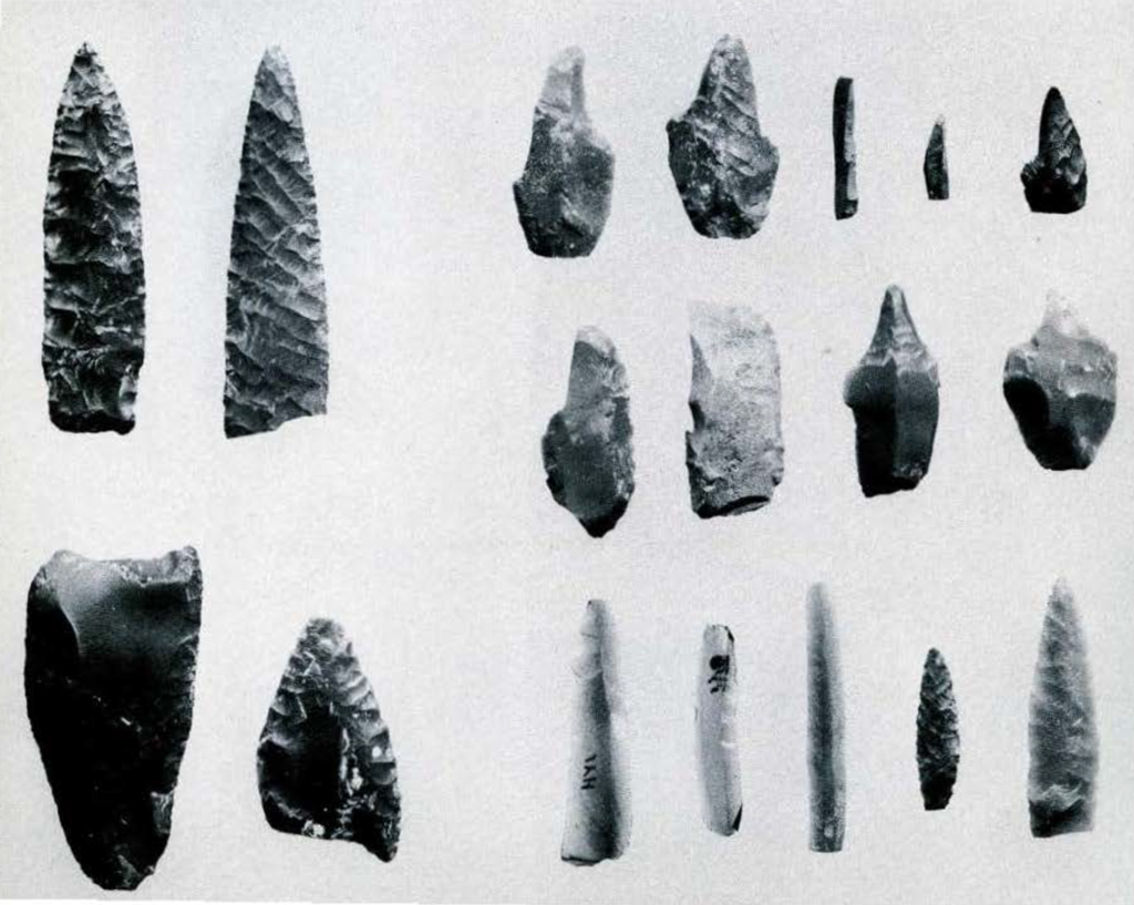
Image Numbler: 40508